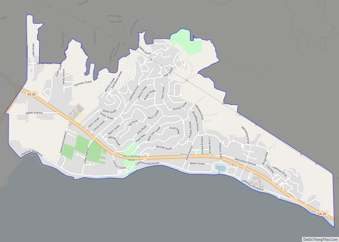
Map of Norco city

Map of Norco city, California

Norco is a city in Riverside County, California, in the United States. Norco is known as Horsetown, USA and prides itself on being a “horse community,” with horse trails, hitching posts, and corrals, and city ordinances requiring construction to have a “traditional, rustic… Western flavor”. As of the 2020 census, the city population was 26,316, … Read more

Map of Nipomo CDP

Map of Nipomo CDP

Nipomo (/nəˈpoʊmoʊ/; Chumash: Nipumuʔ) is a unincorporated town in San Luis Obispo County, California, United States. The population was 16,714 for the 2010 census and grew to 18,176 for the 2020 census. For statistical purposes, the United States Census Bureau has defined Nipomo as a census-designated place (CDP). Nipomo CDP overview: Name: Nipomo CDP LSAD … Read more

Map of Nipinnawasee CDP

Map of Nipinnawasee CDP

Nipinnawasee (formerly Nipinnawassee, Nippinnawasee, and Nippinnawassee) is a census-designated place in Madera County, California, United States. It is located 1 mile (1.6 km) southeast of Miami Mountain in the Sierra Nevada, 14 miles (22.5 km) southeast of Mariposa, at an elevation of 2,930 feet (890 m). The population was 434 at the 2020 census. Nipinnawasee CDP overview: Name: … Read more

Map of North Auburn CDP

Map of North Auburn CDP

North Auburn is a census-designated place (CDP) in Placer County, California, United States. It is part of the Sacramento–Arden-Arcade–Roseville Metropolitan Statistical Area. The population was 13,452 at the 2020 census. North Auburn CDP overview: Name: North Auburn CDP LSAD Code: 57 LSAD Description: CDP (suffix) State: California County: Placer County Elevation: 1,470 ft (448 m) Total Area: … Read more

Map of Norris Canyon CDP

Map of Norris Canyon CDP

Norris Canyon is a census-designated place in Contra Costa County, California. Norris Canyon sits at an elevation of 1063 feet (324 m). The 2010 United States census reported Norris Canyon’s population was 957. Norris Canyon CDP overview: Name: Norris Canyon CDP LSAD Code: 57 LSAD Description: CDP (suffix) State: California County: Contra Costa County Elevation: … Read more

Map of Nord CDP

Map of Nord CDP

Nord is a census-designated place in Butte County, California. Its zip code is 95973 and its area code is 530. It lies at an elevation of 151 feet (46 m). Nord’s population was 320 at the 2010 census. Nord CDP overview: Name: Nord CDP LSAD Code: 57 LSAD Description: CDP (suffix) State: California County: Butte … Read more

Map of North Fair Oaks CDP

Map of North Fair Oaks CDP

North Fair Oaks is a census-designated place and an unincorporated area located in San Mateo County, California adjacent to Redwood City, Atherton, and Menlo Park. As of the 2020 census the area had a total population of 14,027. Because of the large number of residents from one Mexican state the area is also known as … Read more

Map of North El Monte CDP

Map of North El Monte CDP

North El Monte (pronunciation) is a census-designated place (CDP) in the San Gabriel Valley, in Los Angeles County, California, United States. The population was 3,723 at the 2010 census, up from 3,703 at the 2000 census. North El Monte CDP overview: Name: North El Monte CDP LSAD Code: 57 LSAD Description: CDP (suffix) State: California … Read more

Map of North Edwards CDP

Map of North Edwards CDP

North Edwards (formerly, Edgemont Acres and North Muroc) is a census-designated place (CDP) in Kern County, California. Situated in the Mojave Desert, North Edwards is located about 7.2 miles (11.6 km) north-east of Edwards Air Force Base, at an elevation of 2,293 feet (699 m). As of the 2010 census it had a population of 1,058. North … Read more

Map of North Lakeport CDP

Map of North Lakeport CDP

North Lakeport is a census-designated place (CDP) in Lake County, California, United States. The population was 3,314 at the 2010 census, up from 2,879 at the 2000 census. North Lakeport CDP overview: Name: North Lakeport CDP LSAD Code: 57 LSAD Description: CDP (suffix) State: California County: Lake County Total Area: 6.550 sq mi (16.965 km²) Land Area: 3.845 sq mi … Read more

Map of North Highlands CDP

Map of North Highlands CDP

North Highlands is a census-designated place (CDP) in Sacramento County, California, United States. It is part of the Sacramento–Arden-Arcade–Roseville Metropolitan Statistical Area. The population was 42,694 at the 2010 census, down from 44,187 at the 2000 census. North Highlands CDP overview: Name: North Highlands CDP LSAD Code: 57 LSAD Description: CDP (suffix) State: California County: … Read more

Map of North Gate CDP

Map of North Gate CDP

North Gate is a census-designated place in Contra Costa County, California. North Gate sits at an elevation of 253 feet (77 m). The 2010 United States census reported North Gate’s population was 679. North Gate CDP overview: Name: North Gate CDP LSAD Code: 57 LSAD Description: CDP (suffix) State: California County: Contra Costa County Elevation: 253 ft … Read more