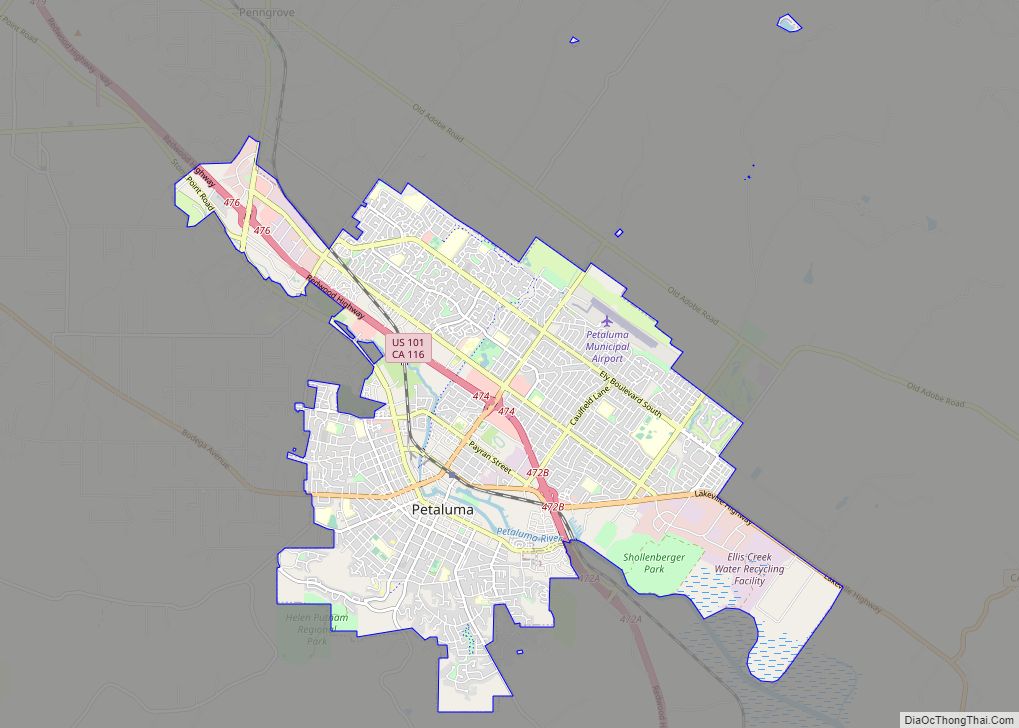
Map of Phillipsville CDP

Map of Phillipsville CDP

Phillipsville (formerly Kettintelbe, Philippsville, and Phillips Flat) is a census-designated place in Humboldt County, California. It is located on the South Fork of the Eel River 7.5 miles (12.1 km) north of Garberville, at an elevation of 289 feet (88 m). It is the southernmost town on the Avenue of the Giants. Near the town is the … Read more

Map of Phelan CDP

Map of Phelan CDP

Phelan is an unincorporated community and census-designated place in San Bernardino County, California, in the Victor Valley of the Mojave Desert, north of the San Gabriel Mountains. The population was 14,304 in the 2010 census. Phelan CDP overview: Name: Phelan CDP LSAD Code: 57 LSAD Description: CDP (suffix) State: California County: San Bernardino County Elevation: … Read more

Map of Peters CDP

Map of Peters CDP

Peters is a census-designated place in San Joaquin County, California. Peters sits at an elevation of 112 feet (34 m). The 2020 United States census reported Peters’ population was 472, which is lower from 672 at The 2010 United States census. Peters CDP overview: Name: Peters CDP LSAD Code: 57 LSAD Description: CDP (suffix) State: California … Read more

Map of Pico Rivera city

Map of Pico Rivera city

Pico Rivera is a city located in southeastern Los Angeles County, California. The city is situated approximately 11 miles (18 km) southeast of downtown Los Angeles, on the eastern edge of the Los Angeles basin, and on the southern edge of the area known as the San Gabriel Valley. As of the 2020 United States census, … Read more

Map of Phoenix Lake CDP

Map of Phoenix Lake CDP

Phoenix Lake CDP overview: Name: Phoenix Lake CDP LSAD Code: 57 LSAD Description: CDP (suffix) State: California County: Tuolumne County FIPS code: 0656870 Online Interactive Map Phoenix Lake online map. Source: Basemap layers from Google Map, Open Street Map (OSM), Arcgisonline, Wmflabs. Boundary Data from Database of Global Administrative Areas. Phoenix Lake location map. Where … Read more

Map of Philo CDP

Map of Philo CDP, California

Philo is a census-designated place in Mendocino County, California, United States. It is located 6 miles (10 km) northwest of Boonville, at an elevation of 331 feet (101 m). The population was 319 at the 2020 census. Philo is located in Anderson Valley in western Mendocino County. Situated along Indian Creek as it flows into the Navarro … Read more

Map of Pike CDP

Map of Pike CDP, California

Pike, formerly Pike City is a census-designated place in Sierra County, California, United States. Pike is 8.5 miles (13.7 km) west-southwest of Alleghany. The community was named after Pike County, Missouri. The post office in Pike opened as Pike City Post Office in 1877, became Pike Post Office in 1895, and closed in 1954. The population … Read more

Map of Pierpoint CDP

Map of Pierpoint CDP

Pierpoint is a census-designated place (CDP) in Tulare County, California, United States. Pierpoint sits at an elevation of 4,610 feet (1,410 m). The 2010 United States census reported Pierpoint’s population was 52. Pierpoint CDP overview: Name: Pierpoint CDP LSAD Code: 57 LSAD Description: CDP (suffix) State: California County: Tulare County Elevation: 4,610 ft (1,410 m) Total Area: 0.408 sq mi … Read more

Map of Piedmont city, California

Map of Piedmont city, California

Piedmont is a small city located in Alameda County, California, United States, completely surrounded by the city of Oakland. Its residential population was 11,270 at the 2020 census. The name comes from the region of Piedmont in Italy, and it means ‘foothill’. Piedmont was incorporated in 1907, and was developed significantly in the 1920s and … Read more

Map of Pine Grove CDP

Map of Pine Grove CDP, California

Pine Grove is a census-designated place in Amador County, California. It lies at an elevation of 2513 feet (766 m). The population was 2,219 at the 2010 census. It is located at 38°24′47″N 120°39′32″W / 38.41306°N 120.65889°W / 38.41306; -120.65889, along State Route 88. The community is in ZIP code 95665 and area code 209. … Read more

Map of Pine Flat CDP

Map of Pine Flat CDP

Pine Flat is a census-designated place (CDP) in Tulare County, California. Pine Flat sits at an elevation of 3,871 feet (1,180 m). The 2020 United States census reported Pine Flat’s population was 206, up from 166 at the 2010 census. Pine Flat CDP overview: Name: Pine Flat CDP LSAD Code: 57 LSAD Description: CDP (suffix) State: … Read more

Map of Pine Canyon CDP

Map of Pine Canyon CDP

Pine Canyon is an unincorporated community and census-designated place (CDP) in Monterey County, California, just south of King City. Pine Canyon sits at an elevation of 515 feet (157 m). As of the 2020 census, the population was 1,871. Pine Canyon CDP overview: Name: Pine Canyon CDP LSAD Code: 57 LSAD Description: CDP (suffix) State: California … Read more