Petaluma (Miwok: Péta Lúuma) is a city in Sonoma County, California, located in the North Bay region of the San Francisco Bay Area. Its population was 59,776 according to the 2020 census.
Petaluma’s name comes from the Miwok village named Péta Lúuma, that was located on the banks of the Petaluma River. The modern city originates in Rancho Petaluma, granted in 1834 to famed Californio statesman Mariano Guadalupe Vallejo, considered to be the founder of Petaluma. Today, Petaluma is known for its well-preserved historic center and as a local hub for the Petaluma Valley region of Sonoma County.
| Name: | Petaluma city |
|---|---|
| LSAD Code: | 25 |
| LSAD Description: | city (suffix) |
| State: | California |
| County: | Sonoma County |
| Incorporated: | April 12, 1858 |
| Elevation: | 13 ft (4 m) |
| Total Area: | 14.52 sq mi (37.61 km²) |
| Land Area: | 14.41 sq mi (37.34 km²) |
| Water Area: | 0.11 sq mi (0.28 km²) 0.74% |
| Total Population: | 59,776 |
| Population Density: | 4,146.8/sq mi (1,601.1/km²) |
| ZIP code: | 94952–94954 |
| Area code: | 707 |
| FIPS code: | 0656784 |
| Website: | cityofpetaluma.net |
Online Interactive Map
Click on ![]() to view map in "full screen" mode.
to view map in "full screen" mode.
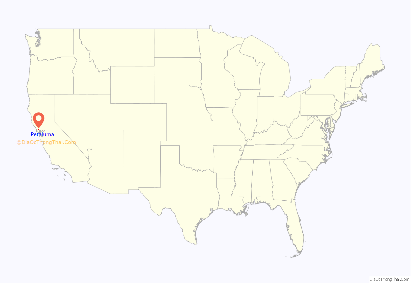
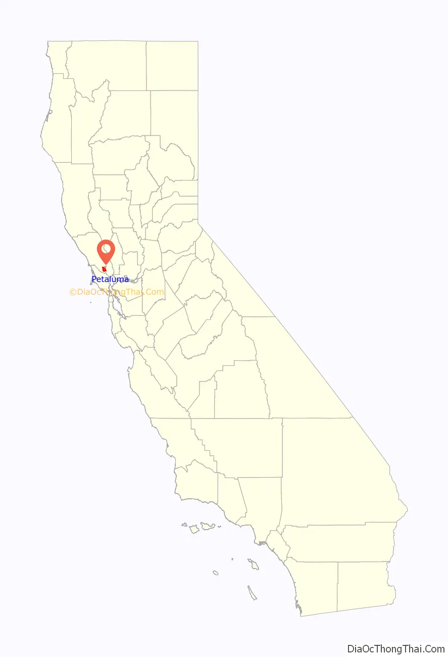
Petaluma location map. Where is Petaluma city?
History
The Coast Miwok resided throughout Marin and southern Sonoma County. The village of Péta Lúuma (Coast Miwok for “backside of the hill”, or “sloping ridge”) was east of the Petaluma River, with a number of other Coast Miwok villages nearby: Wotoki was immediately to the south of Péta Lúuma, on the opposite side of the river; Etem, Likatiut, and Tuchayalin were near today’s downtown; and Tulme and Susuli were just north of today’s city limits.
The Petaluma area was part of a 66,000-acre (270 km) 1834 Mexican land grant by Governor Jose Figueroa to Mariano Guadalupe Vallejo called Rancho Petaluma. In 1836, Vallejo ordered construction of his Rancho Petaluma Adobe, a ranch house near Petaluma, which his family often used as a summer home, while he resided in the neighboring town of Sonoma. Vallejo’s influence and Mexican control in the region began to decline after Vallejo’s arrest during the Bear Flag Revolt in 1846.
Pioneers moved to Petaluma from the eastern United States after James Marshall found gold in the Sierra Nevada in 1848. The town’s position on the Petaluma River in the heart of productive farmland was critical to its growth during the 19th and early 20th centuries. Sailing scows, such as the scow schooner Alma (1892), and steamers plied the river between Petaluma and San Francisco, carrying agricultural produce and raw materials to the burgeoning city of San Francisco during the California Gold Rush.
There were brothels downtown along Petaluma Boulevard, which used to be the main thoroughfare until U.S. Highway 101 was constructed in the 1950s. The Petaluma Historic Commercial District is listed on the National Register of Historic Places.
The Sonoma County Bank Building was the home of the Baker Creek Heirloom Seed Company and the Petaluma Seed Bank until 2019. It was built in 1926.
Petaluma soon became known for its grain milling and chicken processing industries, which continue to the present as a smaller fraction of its commerce. At one time, Petaluma was known as the “Egg Capital of the World,” sparking such nicknames as “Chickaluma”. Petaluma hosted the only known poultry drugstore and is the place where the egg incubator was invented by Lyman Byce in 1879.
One of the largest historic chicken processing plants still stands in the central area of town; this 1930s brick building is no longer used for the chicken industry, but is being evaluated for preservation and change of use. Even though it is no longer known as the Egg Capital of the World, Petaluma maintains a strong agricultural base today with dairy farms, olive groves, vineyards, and berry and vegetable farms.
According to the Army Museum at the Presidio, San Francisco, Petaluma was relatively unharmed during the San Francisco earthquake of April 18, 1906, due to significant stable bedrock underlying the region. As one of the few communities in the region left standing after the earthquake, Petaluma was the staging point for most Sonoma County rescue and relief efforts.
There are extant, pre-1906 buildings and Victorian homes on the western side of the river. The downtown area has suffered many river floods over the years and during the Depression commerce declined. A lack of funds prevented the demolition of the old homes and buildings. In the 1960s there was a counter-culture migration out of San Francisco into Marin County and southern Sonoma County, looking for inexpensive housing in a less urban environment. The old Victorian, Queen Anne and Eastlake style houses were restored. Historic iron-front buildings in the downtown commercial district were also rescued. Traffic and new home development for the most part was rerouted to the east of downtown by the construction of the 101 freeway.
The first official airmail flight took place in 1911, when Fred Wiseman carried a handful of mail from Petaluma to Santa Rosa, including letters from Petaluma postmaster John E. Olmstead and the mayor of Petaluma. Wiseman’s plane ended up in the National Air and Space Museum.
There was a substantial influx of Jewish residents to the area in the first three decades of the 20th century. Most of the settlers were secular Eastern European Jews; they founded today’s B’nai Israel Jewish Center as a secular Jewish community center with no rabbi and only a small area for prayer. The community became active in the poultry industry, and some settlers joined the local labor movement and participated in leftist political organizing, leading to significant conflicts between integrationists who aimed to quietly integrate into Petaluma society and socialists who hoped to change it.
With its large stock of historic buildings, Petaluma has been used as the filming location for numerous movies set in the 1940s, ’50s, and ’60s (see list of movies below). The historic McNear Building is a common film location.
Petaluma pioneered the time-controlled approach to development. After Highway 101 was re-aligned as a freeway in 1955, residential development permits tripled, from 300 in 1969 to 900 in 1971. Because of the region’s soaring population in the sixties, the city enacted the “Petaluma Plan” in 1971. This plan limited the number of building permits to 500 annually for a five-year period beginning in 1972. At the same time Petaluma created a redbelt around the town as a boundary for urban expansion for a stated number of years. Similar to Ramapo, New York, a Residential Development Control System was created to distribute the building permits based on a point system conforming to the city’s general plan to provide for low and moderate income housing and divide development somewhat equally between east and west and single family and multi-family housing.
The stated objectives of Petaluma’s time controlled growth management were to ensure orderly growth; to protect the city’s small town character and surrounding green space; to provide a variety of housing choices; and to maintain adequate water supply and sewage treatment facilities.
The controlled development plan attracted national attention in 1975 when the city was taken to court by the Construction Industry Association. The city’s restriction was upheld by the 9th Circuit Court in 1975 and the Supreme Court denied a petition for writ of certiorari in 1976. This court ruling still forms the foundation for most local growth management ordinances in California.
Despite this history of planned development, the Petaluma City Council voted on April 13, 2009, to eliminate the entire planning department and lay off the whole planning staff. Planning Division responsibilities were subsequently contracted out to the consulting firm Metropolitan Planning Group, which re-hired some of the former planning staff and continues to operate planning services for the city.
In the late 1990s, Petaluma was also known as Telecom Valley due to the telecom startup companies that seemed to multiply from one another, and offer great riches for early stockholders and employees. Two success stories were that of Advanced Fibre Communications (AFC) (now Tellabs), and Cerent, which was purchased by Cisco. Some Cerent employees went on to purchase the Phoenix Theater, a local entertainment venue, which was once an opera house.
In 2021, Petaluma established a goal of achieving carbon neutrality by 2030. In March of that year, the city formally prohibited construction of new gas stations, becoming the first municipality in the world to enact such a ban. The city also streamlined the process of building EV charging stations and potential hydrogen filling stations.
The city has identified about two dozen buildings and districts as Petaluma landmarks.
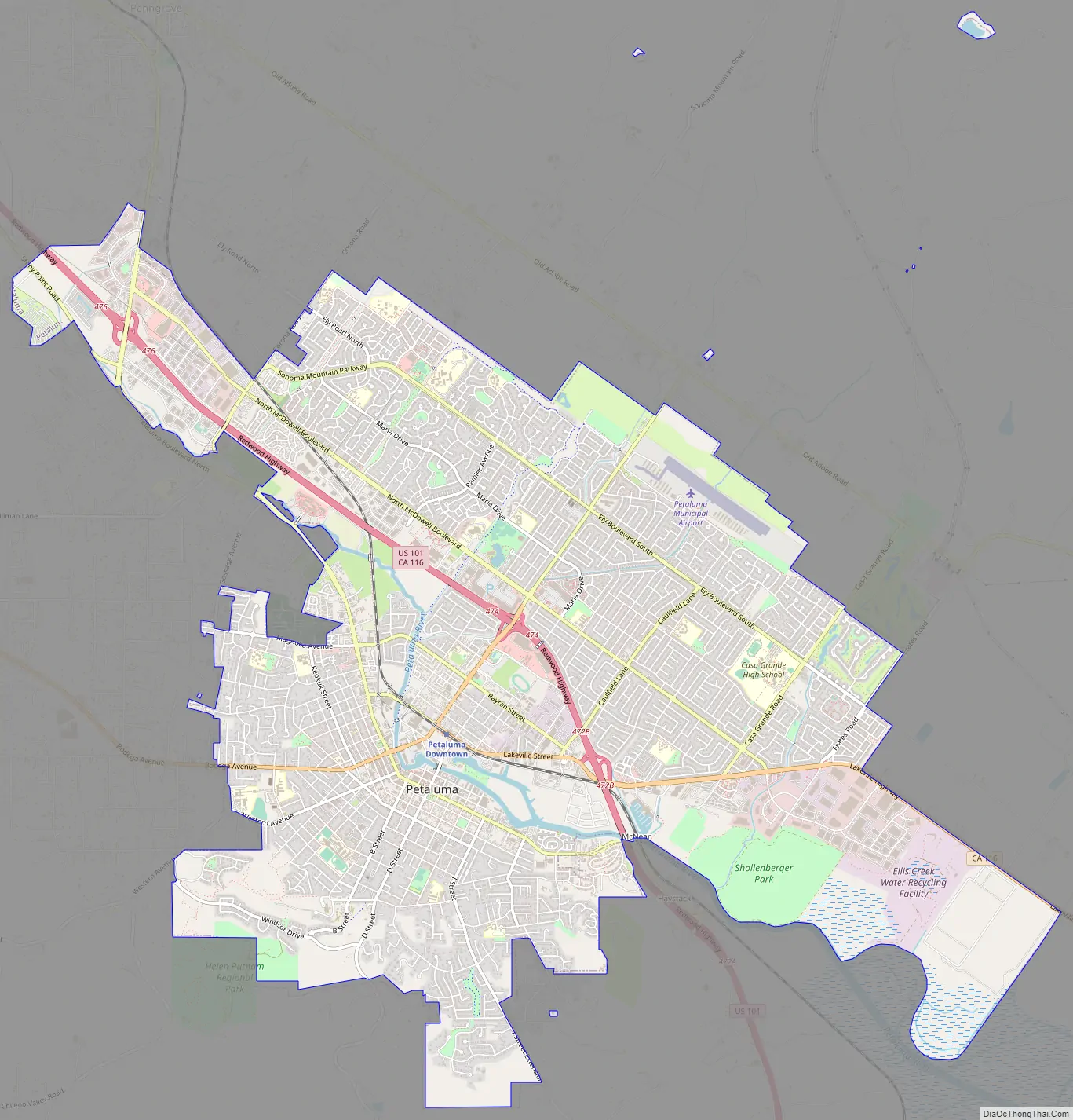
Petaluma Road Map
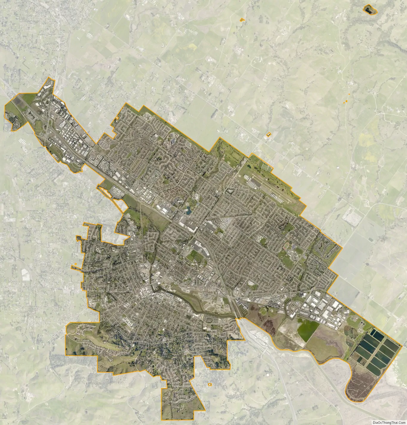
Petaluma city Satellite Map
Geography
Petaluma has a total area of 14.5 sq mi (37.6 km). 14.4 sq mi (37.3 km) of that is land and the remaining 0.1 sq mi (0.3 km) is water. Water is 0.74% of the total area.
It is 32 miles (51 km) north of San Francisco.
Petaluma is flanked by the unincorporated communities of Penngrove to the north and Lakeville to the south.
Petaluma is situated at the northernmost navigable end of the Petaluma River, a tidal estuary that snakes southward to San Pablo Bay. Pollution levels in the river, once considerable, have improved in recent years. A significant amount of the city is in the river’s flood plain, which overflows its banks every few years, particularly in the Payran neighborhood.
Principal environmental noise sources are U.S. Route 101, Petaluma Boulevard, Washington Street and other major arteries. The number of residents that live in a zone of noise exposure greater than 60 CNEL is approximately 4,000.
Climate
Petaluma has a mild Mediterranean climate (Köppen: Csb). Its dry summer is characterized by typically warm days and cool nights with a large degree of diurnal temperature variation. Summer mornings often start out foggy and chilly, but the fog usually clears by midday or so, giving way to clear skies and warmth for the remainder of the day. August is usually the warmest month, with average daily temperatures ranging from 82 °F (28 °C) to 53 °F (12 °C). December is usually the coldest month, with average daily temperatures ranging from 57 °F (14 °C) to 39 °F (4 °C). Winter is cool and rainy, with frost occasionally occurring on clear nights.
Weather Underground’s reporting station in Petaluma had a record high temperature of 111 °F (44 °C) on September 6, 2020. The record low temperature of 16 °F (−9 °C) was recorded on November 14, 1916, and December 14, 1932. The wettest year was 1998 with 45.93 inches (1,167 mm) and the driest year was 1976 with 8.29 inches (211 mm). The wettest month was February 1998 with 19.59 inches (498 mm). The most precipitation in 24 hours was 4.29 inches (109 mm) on December 27, 2004. Although snow is rare in Petaluma, 1.5 inches (38 mm) fell in January 1916, as well as about 3 inches (76 mm) in January 2002.
See also
Map of California State and its subdivision:- Alameda
- Alpine
- Amador
- Butte
- Calaveras
- Colusa
- Contra Costa
- Del Norte
- El Dorado
- Fresno
- Glenn
- Humboldt
- Imperial
- Inyo
- Kern
- Kings
- Lake
- Lassen
- Los Angeles
- Madera
- Marin
- Mariposa
- Mendocino
- Merced
- Modoc
- Mono
- Monterey
- Napa
- Nevada
- Orange
- Placer
- Plumas
- Riverside
- Sacramento
- San Benito
- San Bernardino
- San Diego
- San Francisco
- San Joaquin
- San Luis Obispo
- San Mateo
- Santa Barbara
- Santa Clara
- Santa Cruz
- Shasta
- Sierra
- Siskiyou
- Solano
- Sonoma
- Stanislaus
- Sutter
- Tehama
- Trinity
- Tulare
- Tuolumne
- Ventura
- Yolo
- Yuba
- Alabama
- Alaska
- Arizona
- Arkansas
- California
- Colorado
- Connecticut
- Delaware
- District of Columbia
- Florida
- Georgia
- Hawaii
- Idaho
- Illinois
- Indiana
- Iowa
- Kansas
- Kentucky
- Louisiana
- Maine
- Maryland
- Massachusetts
- Michigan
- Minnesota
- Mississippi
- Missouri
- Montana
- Nebraska
- Nevada
- New Hampshire
- New Jersey
- New Mexico
- New York
- North Carolina
- North Dakota
- Ohio
- Oklahoma
- Oregon
- Pennsylvania
- Rhode Island
- South Carolina
- South Dakota
- Tennessee
- Texas
- Utah
- Vermont
- Virginia
- Washington
- West Virginia
- Wisconsin
- Wyoming


