Map of Guilford Center CDP

Map of Guilford Center CDP

Guilford Center CDP overview: Name: Guilford Center CDP LSAD Code: 57 LSAD Description: CDP (suffix) State: Connecticut County: New Haven County FIPS code: 0935020 Online Interactive Map Guilford Center online map. Source: Basemap layers from Google Map, Open Street Map (OSM), Arcgisonline, Wmflabs. Boundary Data from Database of Global Administrative Areas. Guilford Center location map. … Read more

Map of Heritage Village CDP

Map of Heritage Village CDP

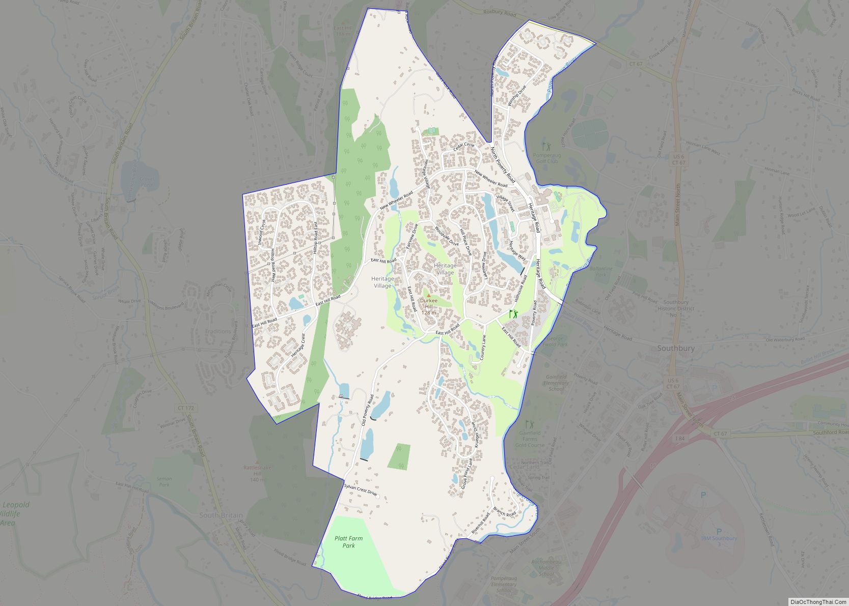
Heritage Village is a census-designated place (CDP) in the town of Southbury in New Haven County, Connecticut, United States. The population was 3,736 at the 2010 census. Heritage Village CDP overview: Name: Heritage Village CDP LSAD Code: 57 LSAD Description: CDP (suffix) State: Connecticut County: New Haven County ZIP code: 06488 (Southbury) Area code: 203/475 … Read more

Map of Hazardville CDP

Map of Hazardville CDP

Hazardville is a section of the town of Enfield, Connecticut, in Hartford County. It is a census-designated place (CDP) that had a total population of 4,599 as of the 2010 census. Hazardville CDP overview: Name: Hazardville CDP LSAD Code: 57 LSAD Description: CDP (suffix) State: Connecticut County: Hartford County Elevation: 180 ft (50 m) Total Area: 3.3 sq mi … Read more

Map of Kensington CDP, Connecticut

Map of Kensington CDP, Connecticut

Kensington is a census-designated place (CDP) and section of the town of Berlin in Hartford County, Connecticut, United States. The Berlin town offices are located in Kensington. The population was 8,459 at the 2010 census. The Henry Hooker House is a historic home in Kensington. Kensington CDP overview: Name: Kensington CDP LSAD Code: 57 LSAD … Read more

Map of Jewett City borough

Map of Jewett City borough

Jewett City borough overview: Name: Jewett City borough LSAD Code: 21 LSAD Description: borough (suffix) State: Connecticut County: New London County FIPS code: 0939940 Online Interactive Map Jewett City online map. Source: Basemap layers from Google Map, Open Street Map (OSM), Arcgisonline, Wmflabs. Boundary Data from Database of Global Administrative Areas. Jewett City location map. … Read more

Map of Higganum CDP

Map of Higganum CDP

Higganum is a village and census-designated place (CDP) in the town of Haddam, a part of Middlesex County, Connecticut, United States. The population was 2,089 at the 2020 census. Higganum CDP overview: Name: Higganum CDP LSAD Code: 57 LSAD Description: CDP (suffix) State: Connecticut County: Middlesex County Elevation: 19 m (61 ft) Total Area: 16.9 km² (6.52 sq mi) Land … Read more

Map of Litchfield borough, Connecticut

Map of Litchfield borough, Connecticut

Litchfield is a borough in, and the village center of, the town of Litchfield in Litchfield County, Connecticut, United States. The population was 1,258 at the 2010 census. The entire borough was designated a Connecticut historic district in 1959 by special act of the state General Assembly and is listed on the National Register of … Read more

Map of Lakeville CDP

Map of Lakeville CDP, Connecticut

Lakeville is a census-designated place (CDP) in Litchfield County, Connecticut, United States, close to Dutchess County, New York. It is within the town of Salisbury, but has its own ZIP Code (06039). As of the 2010 census, the population of Lakeville was 928, out of 3,741 in the entire town of Salisbury. The Hotchkiss School … Read more

Map of Lake Pocotopaug CDP

Map of Lake Pocotopaug CDP

Lake Pocotopaug is an unincorporated village and census-designated place (CDP) in the town of East Hampton in Middlesex County, Connecticut, United States. As of the 2020 census, it had a population of 4,901, up from 3,436 in 2010. It is named for the large local lake, which for years has been a popular resort area. … Read more

Map of Manchester CDP, Connecticut

Map of Manchester CDP, Connecticut

Manchester is a census-designated place (CDP) in Hartford County, Connecticut, United States, comprising the urban center of the town of Manchester. As of the 2010 census, the population of the CDP was 30,577, out of 58,241 in the entire town. Manchester CDP overview: Name: Manchester CDP LSAD Code: 57 LSAD Description: CDP (suffix) State: Connecticut … Read more

Map of Madison Center CDP

Map of Madison Center CDP

Madison Center is a census-designated place (CDP) comprising the primary village and surrounding residential land in the town of Madison, New Haven County, Connecticut, United States. It is in the southern part of the town, surrounding the intersection of U.S. Route 1 with Connecticut Route 79 (Durham Road). The CDP extends south to Long Island … Read more

Map of Long Hill CDP

Map of Long Hill CDP

Long Hill is a census-designated place (CDP) in the town of Groton in New London County, Connecticut, United States. The population was 4,205 at the 2010 census. Long Hill CDP overview: Name: Long Hill CDP LSAD Code: 57 LSAD Description: CDP (suffix) State: Connecticut County: New London County Elevation: 23 ft (7 m) Total Area: 1.6 sq mi (4.1 km²) … Read more