Map of Harlem Heights CDP

Map of Harlem Heights CDP

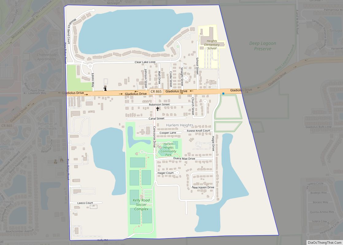
Harlem Heights is an unincorporated community and census-designated place (CDP) in Lee County, Florida, United States. The population was 1,930 at the 2020 census, down from 1,975 at the 2010 census. It is part of the Cape Coral-Fort Myers, Florida Metropolitan Statistical Area. Harlem Heights CDP overview: Name: Harlem Heights CDP LSAD Code: 57 LSAD … Read more

Map of Harbour Heights CDP

Map of Harbour Heights CDP

Harbour Heights is a census-designated place (CDP) in Charlotte County, Florida, United States. The population was 3,428 at the 2020 census. It is part of the Sarasota-Bradenton-Punta Gorda Combined Statistical Area. Harbour Heights CDP overview: Name: Harbour Heights CDP LSAD Code: 57 LSAD Description: CDP (suffix) State: Florida County: Charlotte County Elevation: 10 ft (3 m) Total … Read more

Map of Harbor Bluffs CDP

Map of Harbor Bluffs CDP

Harbor Bluffs is a census-designated place (CDP) in Pinellas County, Florida, United States. The population was 2,860 at the 2010 census. Harbor Bluffs CDP overview: Name: Harbor Bluffs CDP LSAD Code: 57 LSAD Description: CDP (suffix) State: Florida County: Pinellas County Elevation: 10 ft (3 m) Total Area: 0.95 sq mi (2.47 km²) Land Area: 0.69 sq mi (1.79 km²) Water Area: 0.26 sq mi … Read more

Map of Hastings CDP

Map of Hastings CDP, Florida

Hastings is an unincorporated community and agricultural center in St. Johns County, Florida, United States, 18 miles (29 km) southwest of St. Augustine. It was formerly an incorporated town, but it was dissolved in 2018 after a vote by residents. The population was 580 at the 2010 census. As of 2018, the population estimated by the … Read more

Map of Harold CDP

Map of Harold CDP

Harold is an unincorporated community and census-designated place in Santa Rosa County, in the U.S. state of Florida. Its population was 823 as of the 2010 census. A satellite field for Training Air Wing FIVE at Naval Air Station Whiting Field called OLF Harold is located here. Harold CDP overview: Name: Harold CDP LSAD Code: … Read more

Map of Harlem CDP

Map of Harlem CDP, Florida

Harlem is a census-designated place (CDP) in Hendry County, Florida, United States. It was established in 1931. Harlem CDP overview: Name: Harlem CDP LSAD Code: 57 LSAD Description: CDP (suffix) State: Florida County: Hendry County Elevation: 20 ft (6 m) Total Area: 1.05 sq mi (2.73 km²) Land Area: 1.05 sq mi (2.73 km²) Water Area: 0.00 sq mi (0.00 km²) ZIP code: 33440 Area code: … Read more

Map of Haverhill town

Map of Haverhill town, Florida

Haverhill is a town in Palm Beach County, Florida, United States. Haverhill became a town on May 3, 1950, and was named after the city of Haverhill, Massachusetts. The town has maintained a small population since its establishment. The 2010 census recorded a population of 1,873, while the population was estimated at 2,123 in 2018. Haverhill, … Read more

Map of Havana town, Florida

Map of Havana town, Florida

Havana is a town in Gadsden County, Florida, United States, and a suburb of Tallahassee. The population was 1,754 at the 2010 census. It is part of the Tallahassee Metropolitan Statistical Area. The town was named after Havana, Cuba, located about 530 miles (850 km) to the south. Havana town overview: Name: Havana town LSAD Code: … Read more

Map of Hawthorne city, Florida

Map of Hawthorne city, Florida

Hawthorne (/ˈhɔːθoʊrn/ (listen)) is a city in Alachua County, Florida, United States, incorporated in 1881. Indigenous peoples of the Americas had been living in the area since around 100 CE; Hawthorne grew around their trading trails. Throughout its history, Hawthorne has been known for its agriculture, railroad, and rural lifestyle. Hawthorne’s population was 1,478 at … Read more

Map of Hernando Beach CDP

Map of Hernando Beach CDP

Hernando Beach is a census-designated place (CDP) in Hernando County, Florida, United States. The population was 2,299 at the 2010 census. Hernando Beach CDP overview: Name: Hernando Beach CDP LSAD Code: 57 LSAD Description: CDP (suffix) State: Florida County: Hernando County Elevation: 3 ft (1 m) Total Area: 4.88 sq mi (12.64 km²) Land Area: 3.55 sq mi (9.19 km²) Water Area: 1.33 sq mi … Read more

Map of Heritage Pines CDP

Map of Heritage Pines CDP

Heritage Pines is an unincorporated community and census-designated place in Pasco County, Florida, United States. Its population was 2,136 as of the 2010 census. Heritage Pines CDP overview: Name: Heritage Pines CDP LSAD Code: 57 LSAD Description: CDP (suffix) State: Florida County: Pasco County Elevation: 26 ft (8 m) Total Area: 1.095 sq mi (2.84 km²) Land Area: 1.072 sq mi (2.78 km²) … Read more

Map of Heathrow CDP

Map of Heathrow CDP

Heathrow is a census-designated place and an unincorporated suburban community in Seminole County, Florida, United States. Heathrow is on the I-4 Corridor in Central Florida, 19 miles northeast of Orlando and 38 miles southwest of Daytona Beach. Heathrow comprises a master-planned, private gated residential community of approximately 2,200 homes, and the Heathrow International Business Center, … Read more