Map of Richmond Heights CDP

Map of Richmond Heights CDP, Florida

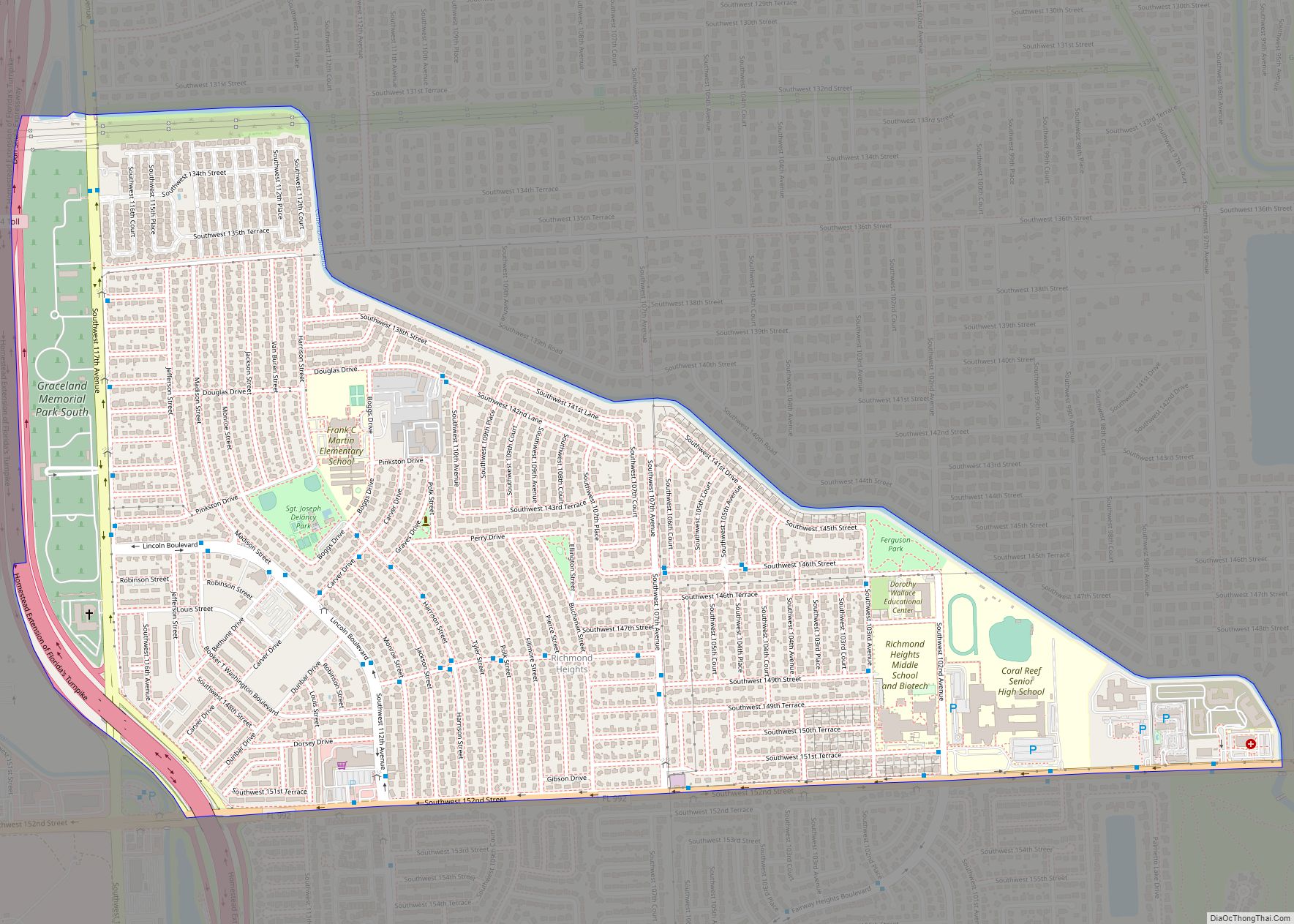
Richmond Heights is a census-designated place (CDP) in Miami-Dade County, Florida, United States. The population was 8,944 at the 2020 census. Richmond Heights CDP overview: Name: Richmond Heights CDP LSAD Code: 57 LSAD Description: CDP (suffix) State: Florida County: Miami-Dade County Elevation: 10 ft (3 m) Total Area: 1.61 sq mi (4.17 km²) Land Area: 1.59 sq mi (4.13 km²) Water Area: 0.01 sq mi … Read more

Map of Redington Shores town

Map of Redington Shores town

Redington Shores is a town in Pinellas County, Florida, United States. The county is part of the Tampa–St. Petersburg–Clearwater, Florida Metropolitan Statistical Area. The population was 2,121 at the 2010 census. Redington Shores town overview: Name: Redington Shores town LSAD Code: 43 LSAD Description: town (suffix) State: Florida County: Pinellas County Elevation: 3 ft (1 m) Total … Read more

Map of Redington Beach town

Map of Redington Beach town

Redington Beach is a town in Pinellas County, Florida, United States. The population was 1,427 at the 2010 census. Redington Beach town overview: Name: Redington Beach town LSAD Code: 43 LSAD Description: town (suffix) State: Florida County: Pinellas County Elevation: 3 ft (1 m) Total Area: 1.31 sq mi (3.39 km²) Land Area: 0.36 sq mi (0.93 km²) Water Area: 0.95 sq mi (2.46 km²) Total … Read more

Map of Ridge Wood Heights CDP

Map of Ridge Wood Heights CDP

Ridge Wood Heights is a census-designated place (CDP) in Sarasota County, Florida, United States. The population was 4,795 at the 2010 United States Census. It is part of the Bradenton–Sarasota–Venice Metropolitan Statistical Area. Ridge Wood Heights CDP overview: Name: Ridge Wood Heights CDP LSAD Code: 57 LSAD Description: CDP (suffix) State: Florida County: Sarasota County … Read more

Map of Ridge Manor CDP

Map of Ridge Manor CDP

Ridge Manor is a census-designated place (CDP) in Hernando County, Florida, United States. The population was 4,513 at the 2010 census. Ridge Manor CDP overview: Name: Ridge Manor CDP LSAD Code: 57 LSAD Description: CDP (suffix) State: Florida County: Hernando County Elevation: 69 ft (21 m) Total Area: 9.04 sq mi (23.41 km²) Land Area: 8.63 sq mi (22.35 km²) Water Area: 0.41 sq mi … Read more

Map of Richmond West CDP

Map of Richmond West CDP

Richmond West is a census-designated place (CDP) in Miami-Dade County, Florida, United States. The population was 35,884 at the 2020 census, up from 31,973 at the 2010 census. Richmond West CDP overview: Name: Richmond West CDP LSAD Code: 57 LSAD Description: CDP (suffix) State: Florida County: Miami-Dade County Elevation: 7 ft (2 m) Total Area: 4.28 sq mi (11.09 km²) … Read more

Map of Rio CDP

Map of Rio CDP, Florida

Rio is an unincorporated community and census-designated place (CDP) in Martin County, Florida, United States. The population was 980 at the 2020 census. Rio is pronounced locally as if it were spelled “Rye-oh”. It is part of the Port St. Lucie Metropolitan Statistical Area. Rio CDP overview: Name: Rio CDP LSAD Code: 57 LSAD Description: … Read more

Map of Rio Pinar CDP

Map of Rio Pinar CDP

Rio Pinar is a census-designated place and unincorporated area in Orange County, Florida, United States. The population was 5,211 at the 2010 census. It is part of the Orlando–Kissimmee Metropolitan Statistical Area and is home to the private Rio Pinar Country Club. Rio Pinar CDP overview: Name: Rio Pinar CDP LSAD Code: 57 LSAD Description: … Read more

Map of Ridgecrest CDP, Florida

Map of Ridgecrest CDP, Florida

Ridgecrest is a census-designated place (CDP) in Pinellas County, Florida, United States. The population was 2,558 at the 2010 census. Ridgecrest CDP overview: Name: Ridgecrest CDP LSAD Code: 57 LSAD Description: CDP (suffix) State: Florida County: Pinellas County Elevation: 56 ft (17 m) Total Area: 0.91 sq mi (2.35 km²) Land Area: 0.89 sq mi (2.30 km²) Water Area: 0.02 sq mi (0.05 km²) Total Population: … Read more

Map of Riverview CDP, Florida

Map of Riverview CDP, Florida

Riverview is an unincorporated census-designated place in Hillsborough County, Florida, United States. It is located south of Brandon. The population was 107,396 in the 2020 census, up from 71,050 in the 2010 census. Many of Tampa Bay’s radio and television stations broadcast from an antenna farm in the Riverview area, on Boyette Road, southeast of … Read more

Map of River Ridge CDP

Map of River Ridge CDP, Florida

River Ridge is an unincorporated community and census-designated place in Pasco County, Florida, United States. Its population was 4,702 as of the 2010 census. River Ridge CDP overview: Name: River Ridge CDP LSAD Code: 57 LSAD Description: CDP (suffix) State: Florida County: Pasco County Elevation: 36 ft (11 m) Total Area: 4.418 sq mi (11.44 km²) Land Area: 4.418 sq mi (11.44 km²) … Read more

Map of River Park CDP

Map of River Park CDP

River Park is a census-designated place (CDP) in St. Lucie County, Florida, United States. The population was 5,222 at the 2010 census, at which time it was listed as Port St. Lucie-River Park. It is part of the Port St. Lucie Metropolitan Statistical Area. River Park CDP overview: Name: River Park CDP LSAD Code: 57 … Read more