Map of Big Coppitt Key CDP

Map of Big Coppitt Key CDP

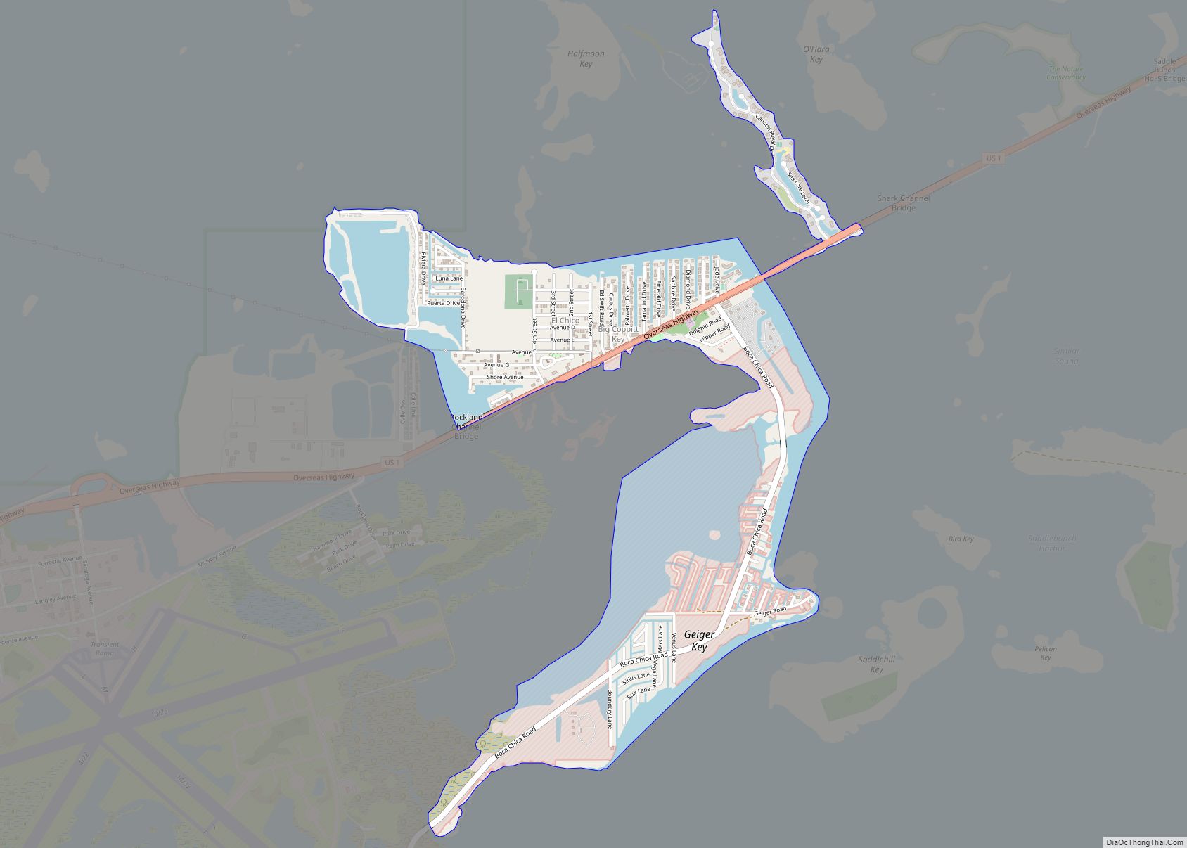
Big Coppitt Key is an island in Monroe County, Florida, United States, in the lower Florida Keys. The name is said to be a derivation of the old English word “coppice”, meaning thicket. According to A.D. Bache, in the notes for his coast survey conducted in 1861, this key was the location of Happy Jack’s … Read more

Map of Beverly Hills CDP, Florida

Map of Beverly Hills CDP, Florida

Beverly Hills is an unincorporated community and census-designated place in Citrus County, Florida, United States. The population was 8,445 at the 2010 census. Beverly Hills CDP overview: Name: Beverly Hills CDP LSAD Code: 57 LSAD Description: CDP (suffix) State: Florida County: Citrus County Elevation: 102 ft (31 m) Total Area: 2.97 sq mi (7.68 km²) Land Area: 2.97 sq mi (7.68 km²) Water … Read more

Map of Beverly Beach town

Map of Beverly Beach town

Beverly Beach is a town in Flagler County, Florida, United States. The population was 338 at the 2010 census, down from 547 in 2000. It is part of the Deltona–Daytona Beach–Ormond Beach, FL metropolitan statistical area. Beverly Beach town overview: Name: Beverly Beach town LSAD Code: 43 LSAD Description: town (suffix) State: Florida County: Flagler … Read more

Map of Bithlo CDP

Map of Bithlo CDP

Bithlo is a census-designated place and an unincorporated community in Orange County, Florida, United States. The population was 8,268 at the 2010 census, up from 4,626 at the 2000 census. It is part of the Orlando–Kissimmee Metropolitan Statistical Area. The Bithlo Post Office opened in 1922. For 20 years in the early 20th century, Bithlo … Read more

Map of Biscayne Park village

Map of Biscayne Park village

Biscayne Park is a village in Miami-Dade County, Florida, United States. Biscayne Park was developed in the 1920s by Arthur Griffing and annexed into the city of Miami in 1925. With the arrival of the Great Depression, Miami gave up its jurisdiction, and Biscayne Park was incorporated as its own town in 1931. In 1933, … Read more

Map of Big Pine Key CDP

Map of Big Pine Key CDP

Big Pine Key is a census-designated place and unincorporated community in Monroe County, Florida, United States, on an island of the same name in the Florida Keys. As of the 2020 census, the town had a total population of 4,521. Big Pine Key CDP overview: Name: Big Pine Key CDP LSAD Code: 57 LSAD Description: … Read more

Map of Bloomingdale CDP

Map of Bloomingdale CDP, Florida

Bloomingdale is an unincorporated census-designated place in Hillsborough County, Florida, United States. The population was 22,711 at the 2010 census. The ZIP Codes serving the community are 33511 (which is addressed to Brandon) and 33596 (which is addressed to Valrico). Bloomingdale CDP overview: Name: Bloomingdale CDP LSAD Code: 57 LSAD Description: CDP (suffix) State: Florida … Read more

Map of Black Hammock CDP

Map of Black Hammock CDP

Black Hammock is an unincorporated community and census-designated place in Seminole County, Florida, United States. Its population was 1,144 as of the 2010 census. Black Hammock CDP overview: Name: Black Hammock CDP LSAD Code: 57 LSAD Description: CDP (suffix) State: Florida County: Seminole County Elevation: 10 ft (3 m) Total Area: 10.911 sq mi (28.26 km²) Land Area: 10.911 sq mi (28.26 km²) … Read more

Map of Black Diamond CDP

Map of Black Diamond CDP, Florida

Black Diamond is a census-designated place (CDP) in Citrus County, Florida, United States. The population was 1,101 at the 2010 census, up from 694 in 2000. Black Diamond CDP overview: Name: Black Diamond CDP LSAD Code: 57 LSAD Description: CDP (suffix) State: Florida County: Citrus County Elevation: 56 ft (17 m) Total Area: 3.94 sq mi (10.21 km²) Land Area: … Read more

Map of Bokeelia CDP

Map of Bokeelia CDP

Bokeelia is an unincorporated community and census-designated place (CDP) located on Pine Island in Lee County, Florida, United States. As of the 2020 census, the CDP had a population of 1,855, up from 1,780 at the 2010 census. It is part of the Cape Coral-Fort Myers, Florida Metropolitan Statistical Area. Bokeelia is still home to … Read more

Map of Boca Raton city

Map of Boca Raton city

Boca Raton (/rəˈtoʊn/ rə-TOHN; Spanish: Boca Ratón, [ˈboka raˈton]) is a city in Palm Beach County, Florida, United States. The population was 97,422 in the 2020 census and it ranked as the 344th largest city in the United States in 2021. However, many people with a Boca Raton postal address live outside of municipal boundaries, … Read more

Map of Blountstown city

Map of Blountstown city

Blountstown is a city and the county seat of Calhoun County, Florida, United States. . As of the 2020 census, the city had a population of 2,266. Blountstown city overview: Name: Blountstown city LSAD Code: 25 LSAD Description: city (suffix) State: Florida County: Calhoun County Elevation: 62 ft (19 m) Total Area: 3.20 sq mi (8.28 km²) Land Area: 3.19 sq mi … Read more