Map of Woodbury city

Map of Woodbury city, Georgia

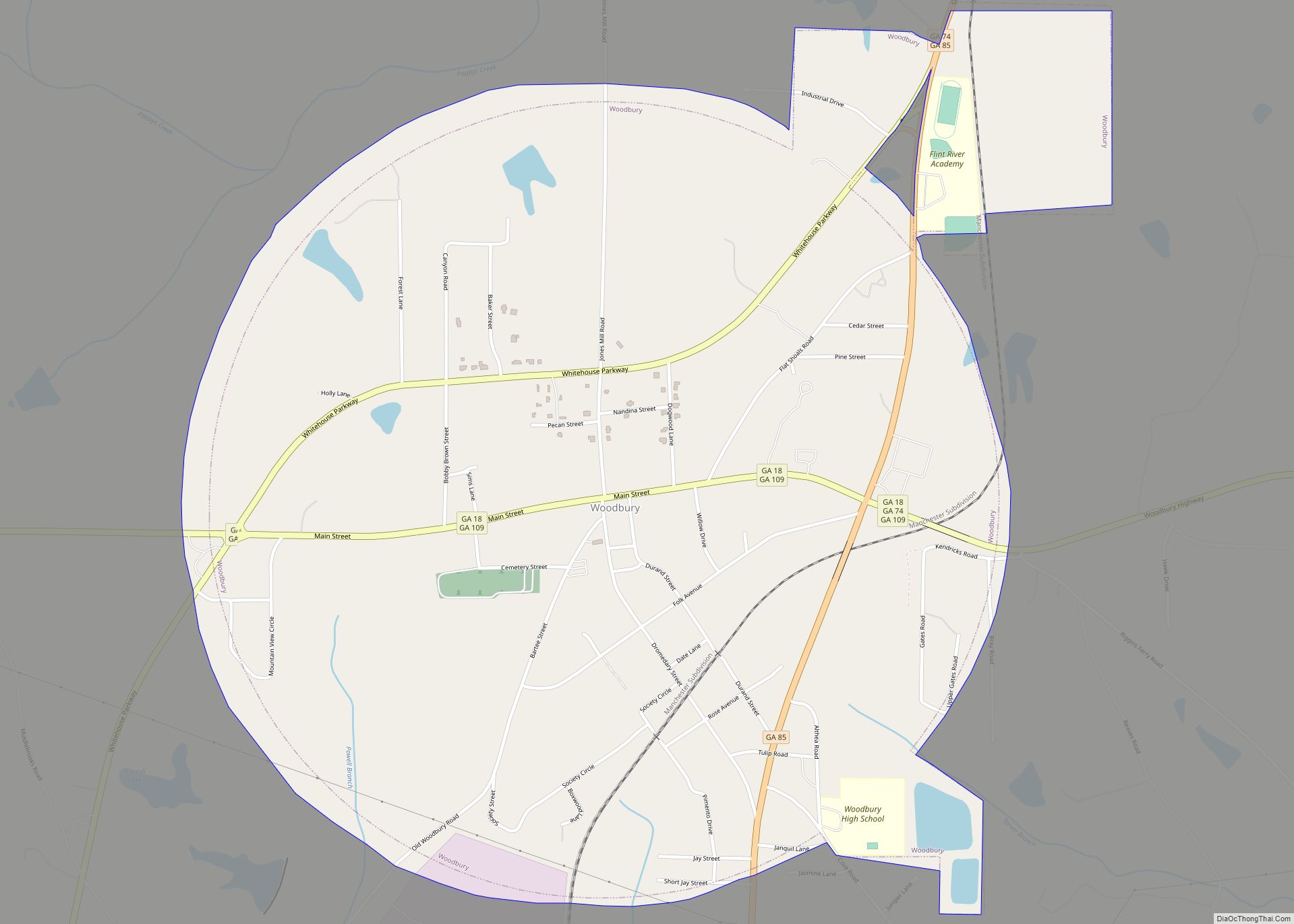
Woodbury is a city in Meriwether County, Georgia, United States. The population was 908 at the 2020 census. Woodbury city overview: Name: Woodbury city LSAD Code: 25 LSAD Description: city (suffix) State: Georgia County: Meriwether County Elevation: 827 ft (252 m) Total Area: 2.10 sq mi (5.44 km²) Land Area: 2.07 sq mi (5.36 km²) Water Area: 0.03 sq mi (0.08 km²) Total Population: 908 Population … Read more

Map of Wrens city

Map of Wrens city

Wrens is a city in Jefferson County, Georgia, United States. The population was 2,187 at the 2010 census. It is located on U.S. Route 1, thirty miles south of Augusta. Wrens city overview: Name: Wrens city LSAD Code: 25 LSAD Description: city (suffix) State: Georgia County: Jefferson County Elevation: 407 ft (124 m) Total Area: 3.14 sq mi (8.13 km²) … Read more

Map of Woolsey town

Map of Woolsey town

Woolsey is a town in Fayette County, Georgia, United States. The population was 158 at the 2010 census. Woolsey town overview: Name: Woolsey town LSAD Code: 43 LSAD Description: town (suffix) State: Georgia County: Fayette County Elevation: 837 ft (255 m) Total Area: 0.84 sq mi (2.18 km²) Land Area: 0.82 sq mi (2.12 km²) Water Area: 0.02 sq mi (0.06 km²) Total Population: 206 Population … Read more

Map of Woodville city, Georgia

Map of Woodville city, Georgia

Woodville is a city in Greene County, Georgia, United States. The population was 321 at the 2010 census, down from 400 at the 2000 census. Woodville city overview: Name: Woodville city LSAD Code: 25 LSAD Description: city (suffix) State: Georgia County: Greene County Elevation: 702 ft (214 m) Total Area: 4.98 sq mi (12.90 km²) Land Area: 4.96 sq mi (12.85 km²) Water … Read more

Map of Yonah CDP

Map of Yonah CDP

Yonah is a census-designated place in White County, Georgia, United States. Its population was 657 as of the 2020 census. Georgia State Route 75 passes through the community. Yonah CDP overview: Name: Yonah CDP LSAD Code: 57 LSAD Description: CDP (suffix) State: Georgia County: White County Elevation: 1,539 ft (469 m) Total Area: 3.15 sq mi (8.17 km²) Land Area: … Read more

Map of Yatesville town

Map of Yatesville town, Georgia

Yatesville is a town in Upson County, Georgia, United States. The population was 408 at the 2000 census. Yatesville town overview: Name: Yatesville town LSAD Code: 43 LSAD Description: town (suffix) State: Georgia County: Upson County Elevation: 797 ft (243 m) Total Area: 0.88 sq mi (2.27 km²) Land Area: 0.86 sq mi (2.24 km²) Water Area: 0.01 sq mi (0.03 km²) Total Population: 394 Population … Read more

Map of Wrightsville city, Georgia

Map of Wrightsville city, Georgia

Wrightsville is a city in Johnson County, Georgia, United States. The population was 2,195 at the 2010 census, down from 2,223 at the 2000 census. The city limits include Johnson State Prison on the northeast side of town. The city is the county seat of Johnson County. Wrightsville is part of the Dublin Micropolitan Statistical … Read more

Map of Zebulon city

Map of Zebulon city, Georgia

Zebulon is a city in Pike County, Georgia, United States. The population was 1,174 at the 2010 census. The city is the county seat of Pike County. The city and county were named after explorer Zebulon Pike. Zebulon city overview: Name: Zebulon city LSAD Code: 25 LSAD Description: city (suffix) State: Georgia County: Pike County … Read more

Map of Young Harris city

Map of Young Harris city

Young Harris is a city in Towns County, Georgia, United States. The population was 899 at the 2010 census. Young Harris is home to Young Harris College, after which it was named. Young Harris city overview: Name: Young Harris city LSAD Code: 25 LSAD Description: city (suffix) State: Georgia County: Towns County Elevation: 1,896 ft (578 m) … Read more