Map of Kahaluu CDP

Map of Kahaluu CDP

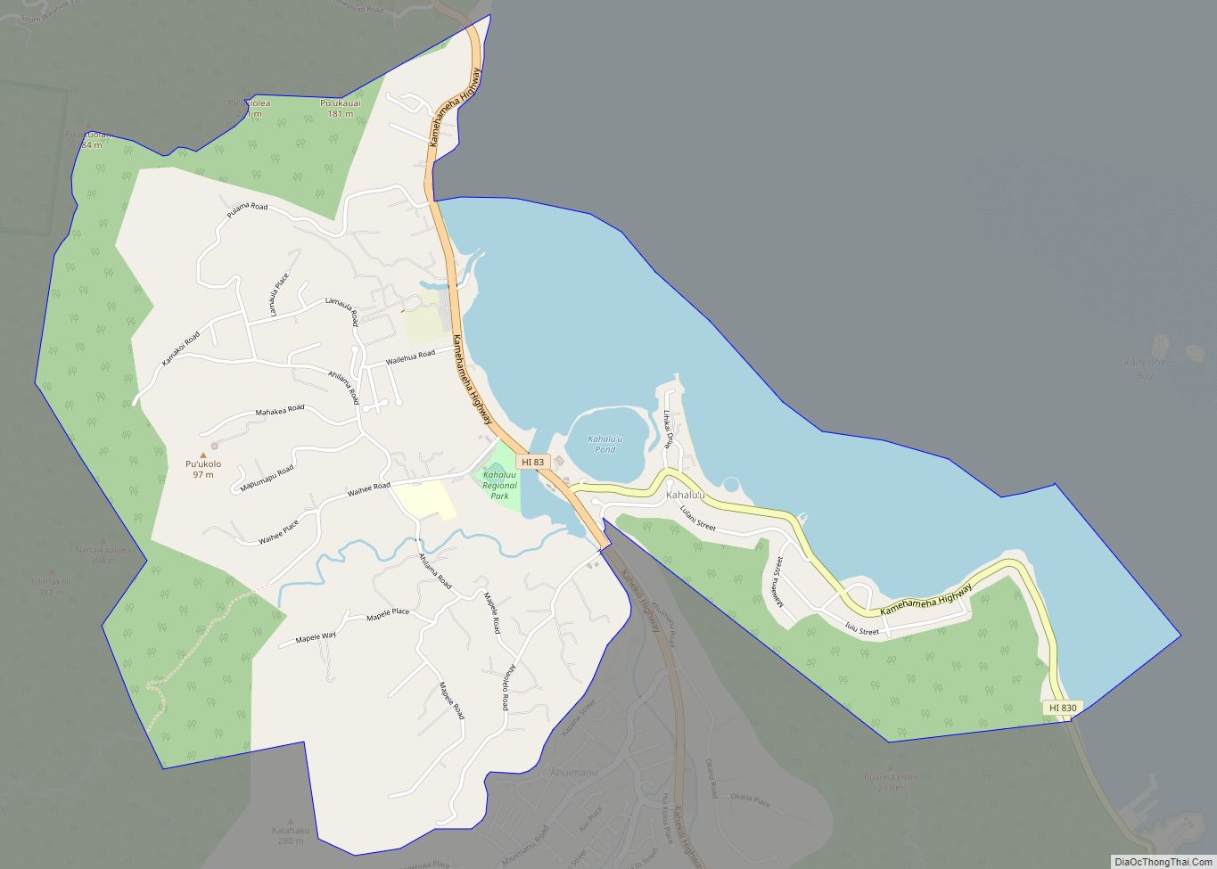
Kahaluʻu (/ˌkɑːhəˈluːʔuː/; Hawaiian pronunciation: [ˈkɐhɐˈluʔu]) is a residential community and census-designated place (CDP) in the City and County of Honolulu, Hawaii, United States, in the District of Koolaupoko on the island of Oahu. In Hawaiian ka haluʻu means “diving place”. As of the 2020 census, the CDP had a total population of 5,241. Kahaluu CDP overview: … Read more

Map of Kahaluu-Keauhou CDP

Map of Kahaluu-Keauhou CDP

Kahaluʻu-Keauhou is a census-designated place (CDP) in Hawaiʻi County, Hawaii, United States. The population was 3,549 at the 2010 census, up from 2,414 at the 2000 census. Kahaluu-Keauhou CDP overview: Name: Kahaluu-Keauhou CDP LSAD Code: 57 LSAD Description: CDP (suffix) State: Hawaii County: Hawaii County Elevation: 100 ft (30 m) Total Area: 10.28 sq mi (26.63 km²) Land Area: 8.01 sq mi … Read more

Map of Kalaheo CDP

Map of Kalaheo CDP

Kalāheo (literally, “the proud day” in Hawaiian) is an unincorporated community and census-designated place (CDP) in Kauaʻi County, island of Kauaʻi, Hawaiʻi, United States. The population was 4,996 at the 2020 census, up from 3,913 at the 2000 census. The National Tropical Botanical Garden is located in Kalāheo. Kalaheo CDP overview: Name: Kalaheo CDP LSAD … Read more

Map of Kalaeloa CDP

Map of Kalaeloa CDP

Kalaeloa (Hawaiian pronunciation: [kəlɐe̯ˈlowə]) is a census-designated place (CDP) in Honolulu County, Hawaii, United States. The population was 2,364 at the 2020 census. The community occupies the location of the former Naval Air Station Barbers Point, which was closed in 1999 and subsequently transferred to the State of Hawaiʻi. The geographical name, Ka lae loa, means … Read more

Map of Kahului CDP

Map of Kahului CDP

Kahului (Hawaiian pronunciation: [kəhuˈluwi]) is a census-designated place (CDP) in Maui County in the U.S. state of Hawaii. It hosts the county’s main airport (Kahului Airport), a deep-draft harbor, light industrial areas, and commercial shopping centers. The population was 28,219 at the 2020 census. Kahului is part of the Kahului-Wailuku-Lahaina Metropolitan Statistical Area which comprises all … Read more

Map of Kaneohe Station CDP

Map of Kaneohe Station CDP

Marine Corps Base Hawaii (MCBH), formerly Marine Corps Air Station Kaneohe Bay and originally Naval Air Station Kaneohe Bay, is a U.S. Marine Corps facility and air station located on the Mokapu Peninsula of windward O’ahu in the City & County of Honolulu. Marine Corps Base Hawaii is home to Marines, Sailors, their family members, … Read more

Map of Kalihiwai CDP

Map of Kalihiwai CDP

Kalihiwai (literally, “Kalihi with a stream” in Hawaiian where “kalihi” means “the edge”) is a census-designated place (CDP) in Kauaʻi County, Hawaiʻi, United States. The population was 361 at the 2020 census. Kalihiwai CDP overview: Name: Kalihiwai CDP LSAD Code: 57 LSAD Description: CDP (suffix) State: Hawaii County: Kauai County Elevation: 33 ft (10 m) Total Area: … Read more

Map of Kalaoa CDP

Map of Kalaoa CDP

Kalaoa is a census-designated place (CDP) in Hawaiʻi County, Hawaiʻi, United States. The population was 9,644 as of the 2010 census, up from 6,794 residents at the 2000 census. Kalaoa CDP overview: Name: Kalaoa CDP LSAD Code: 57 LSAD Description: CDP (suffix) State: Hawaii County: Hawaii County Elevation: 680 ft (210 m) Total Area: 45.6 sq mi (118.1 km²) Land … Read more

Map of Kapaau CDP

Map of Kapaau CDP

Kapa’au (Hawaiian: Kapaʻau) is an unincorporated community in Hawaiʻi County, Hawaii, United States. Located at the northern tip of the big island of Hawaiʻi, it is celebrated as the birthplace of Kamehameha I. For statistical purposes, the United States Census Bureau has defined Kapa’au as a census-designated place (CDP). The census definition of the area … Read more

Map of Kapaa CDP

Map of Kapaa CDP

Kapaʻa (Kauaʻi dialect: Tapaʻa) is an unincorporated community and census-designated place (CDP) in Kauaʻi County, Hawaiʻi, United States. It is the most populous town in the island of Kauai, with a population of 11,652 as of the 2020 census, up from 9,471 at the 2000 census. Kapaʻa is a Hawaiian adjective meaning “solid”. Kapaa CDP … Read more

Map of Kaneohe CDP

Map of Kaneohe CDP

Kāneʻohe (Hawaiian pronunciation: [kaːneˈʔohe]) is a census-designated place (CDP) included in the City and County of Honolulu and in Hawaiʻi state District of Koʻolaupoko on the island of Oʻahu. In the Hawaiian language, kāne ʻohe means “bamboo man”. According to an ancient Hawaiian story, a local woman compared her husband’s cruelty to the sharp edge of … Read more

Map of Kaumakani CDP

Map of Kaumakani CDP

Kaumakani (literally, “place in the wind” in the Hawaiian language) is a census-designated place (CDP) in Kauaʻi County, Hawaiʻi, United States. The population was 749 at the 2010 census, up from 607 at the 2000 census. Kaumakani CDP overview: Name: Kaumakani CDP LSAD Code: 57 LSAD Description: CDP (suffix) State: Hawaii County: Kauai County Elevation: … Read more