Map of Towanda village

Map of Towanda village, Illinois

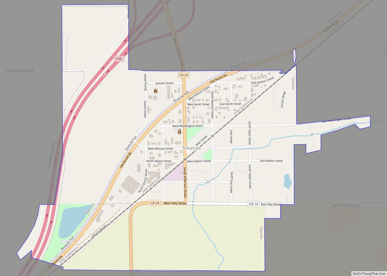
Towanda is a village in McLean County, Illinois, United States. The population was 431 at the 2020 census. It is part of the Bloomington–Normal Metropolitan Statistical Area. Towanda village overview: Name: Towanda village LSAD Code: 47 LSAD Description: village (suffix) State: Illinois County: McLean County Founded: May 5, 1875 Elevation: 781 ft (238 m) Total Area: 0.74 sq mi … Read more

Map of Tremont village

Map of Tremont village, Illinois

Tremont is a village in Tazewell County, Illinois, United States. The population was 2,277 at the 2020 census. Tremont is located 14 miles southeast of Peoria. Tremont village overview: Name: Tremont village LSAD Code: 47 LSAD Description: village (suffix) State: Illinois County: Tazewell County Founded: 1834 Elevation: 650 ft (200 m) Total Area: 1.19 sq mi (3.07 km²) Land Area: … Read more

Map of Tower Lakes village

Map of Tower Lakes village

Tower Lakes is a village in Lake County, Illinois, United States. Per the 2020 census, the population was 1,226. Tower Lakes village overview: Name: Tower Lakes village LSAD Code: 47 LSAD Description: village (suffix) State: Illinois County: Lake County Total Area: 1.04 sq mi (2.70 km²) Land Area: 0.92 sq mi (2.38 km²) Water Area: 0.13 sq mi (0.32 km²) Total Population: 1,226 Population … Read more

Map of Trout Valley village

Map of Trout Valley village, Illinois

Trout Valley is a village in McHenry County, Illinois, United States. It was incorporated as a village on 19 March 1996. Per the 2020 census, the population was 515. Trout Valley village overview: Name: Trout Valley village LSAD Code: 47 LSAD Description: village (suffix) State: Illinois County: McHenry County Founded: March 19, 1996 Total Area: … Read more

Map of Trenton city, Illinois

Map of Trenton city, Illinois

Trenton is a city in Clinton County, Illinois, United States. The population was 2,690 at the 2020 census. Trenton city overview: Name: Trenton city LSAD Code: 25 LSAD Description: city (suffix) State: Illinois County: Clinton County Elevation: 486 ft (148 m) Total Area: 1.88 sq mi (4.88 km²) Land Area: 1.88 sq mi (4.88 km²) Water Area: 0.00 sq mi (0.00 km²) Total Population: 2,690 Population … Read more

Map of Troy city, Illinois

Map of Troy city, Illinois

Troy is a city in Madison County, Illinois, United States. The population was 10,960 at the 2020 census, up from 9,888 in 2010. Troy is part of the St. Louis Metropolitan Statistical Area. Its namesake in Lincoln County, Missouri, is also part of this MSA, making it (along with the two O’Fallons in Illinois and … Read more

Map of Troy Grove village

Map of Troy Grove village

Troy Grove is a village in LaSalle County, Illinois, United States. The population was 225 at the 2020 census, down from 250 at the 2010 census. It is part of the Ottawa, IL Micropolitan Statistical Area. Troy Grove is notable as the birthplace of Wild Bill Hickok and Kate Austin. It is home to the … Read more

Map of Twin Grove CDP

Map of Twin Grove CDP

Twin Grove is an unincorporated community and census-designated place (CDP) in McLean County, Illinois, United States. As of the 2020 census, Twin Grove had a population of 1,524. Twin Grove CDP overview: Name: Twin Grove CDP LSAD Code: 57 LSAD Description: CDP (suffix) State: Illinois County: McLean County Elevation: 817 ft (249 m) Total Area: 3.97 sq mi (10.29 km²) … Read more

Map of Tuscola city

Map of Tuscola city, Illinois

Tuscola is a city in Douglas County, Illinois, United States. The population was 4,636 at the 2020 census. It is the county seat of Douglas County. Tuscola city overview: Name: Tuscola city LSAD Code: 25 LSAD Description: city (suffix) State: Illinois County: Douglas County Elevation: 646 ft (197 m) Total Area: 2.96 sq mi (7.66 km²) Land Area: 2.95 sq mi (7.64 km²) … Read more

Map of Union Hill village

Map of Union Hill village

Union Hill is a village in Kankakee County, Illinois, United States. The population was 58 at the 2010 census. It is included in the Kankakee–Bradley, Illinois Metropolitan Statistical Area. Union Hill village overview: Name: Union Hill village LSAD Code: 47 LSAD Description: village (suffix) State: Illinois County: Kankakee County Elevation: 616 ft (188 m) Total Area: 0.05 sq mi … Read more

Map of Ullin village

Map of Ullin village

Ullin is a village in Pulaski County, Illinois, United States. The population was 463 at the 2010 census. Ullin village overview: Name: Ullin village LSAD Code: 47 LSAD Description: village (suffix) State: Illinois County: Pulaski County Elevation: 325 ft (99 m) Total Area: 2.86 sq mi (7.42 km²) Land Area: 2.81 sq mi (7.28 km²) Water Area: 0.05 sq mi (0.14 km²) Total Population: 466 Population … Read more

Map of University Park village, Illinois

Map of University Park village, Illinois

University Park is a village in Will County with a small portion in Cook County in the U.S. state of Illinois. It is a south suburb of Chicago. The village is one of the region’s few planned communities; it was developed in the 1960s as Wood Hill, then Park Forest South, and finally University Park. … Read more