Map of Willow Hill village

Map of Willow Hill village

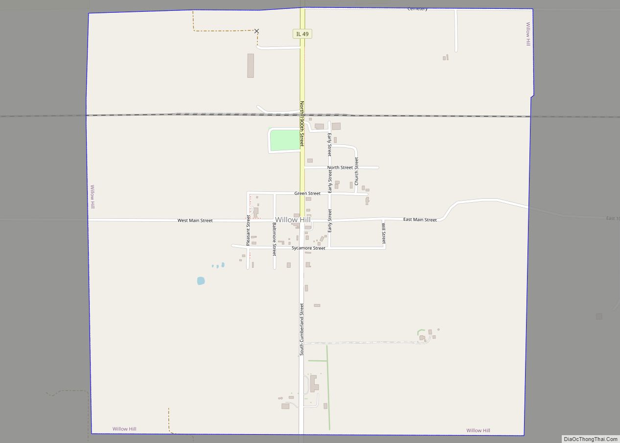
Willow Hill is a village in Jasper County, Illinois. The population was 230 at the 2010 census. Willow Hill village overview: Name: Willow Hill village LSAD Code: 47 LSAD Description: village (suffix) State: Illinois County: Jasper County Elevation: 499 ft (152 m) Total Area: 1.04 sq mi (2.69 km²) Land Area: 1.04 sq mi (2.69 km²) Water Area: 0.00 sq mi (0.00 km²) Total Population: 172 … Read more

Map of Willisville village, Illinois

Map of Willisville village, Illinois

Willisville is a village in Perry County, Illinois, United States. The population was 633 at the 2010 census. Willisville village overview: Name: Willisville village LSAD Code: 47 LSAD Description: village (suffix) State: Illinois County: Perry County Elevation: 495 ft (151 m) Total Area: 0.39 sq mi (1.01 km²) Land Area: 0.39 sq mi (1.01 km²) Water Area: 0.00 sq mi (0.00 km²) Total Population: 579 Population … Read more

Map of Wilmington city, Illinois

Map of Wilmington city, Illinois

Wilmington is a city in Will County, Illinois, United States. Located on IL-53 along the east bank of the Kankakee River, it is approximately 60 miles south-west from downtown Chicago (the Chicago Loop). The population was 5,724 at the 2010 census. Wilmington city overview: Name: Wilmington city LSAD Code: 25 LSAD Description: city (suffix) State: … Read more

Map of Wilmette village

Map of Wilmette village

Wilmette is a village in New Trier Township, Cook County, Illinois, United States. Bordering Lake Michigan and Evanston, Illinois, it is located 14 miles (23 km) north of Chicago’s downtown district. Wilmette had a population of 28,170 at the 2020 census. The first and only Baháʼí House of Worship in North America is located here. Wilmette … Read more

Map of Willowbrook CDP, Illinois

Map of Willowbrook CDP, Illinois

Willow Brook Estates is an unincorporated census-designated place in Will County, Illinois, United States. The population was 1,346 at the 2020 census. it is considered a far south suburb of Chicago. Willowbrook CDP overview: Name: Willowbrook CDP LSAD Code: 57 LSAD Description: CDP (suffix) State: Illinois County: Will County Elevation: 715 ft (218 m) Total Area: 3.4 sq mi … Read more

Map of Windsor village, Illinois

Map of Windsor village, Illinois

Windsor, also known as New Windsor, is a village in Rivoli Township, Mercer County, Illinois, United States. The population was 668 at the 2020 census, down from 748 in 2010. The official name is the “Village of Windsor”, but “New Windsor” is the commonly used name, including by the New Windsor Fire Department and the … Read more

Map of Winchester city, Illinois

Map of Winchester city, Illinois

Winchester is a city in and the county seat of Scott County, Illinois, United States. The population was 1,593 at the 2010 census. Winchester is part of the Jacksonville Micropolitan Statistical Area. Winchester city overview: Name: Winchester city LSAD Code: 25 LSAD Description: city (suffix) State: Illinois County: Scott County Elevation: 545 ft (166 m) Total Area: … Read more

Map of Wilsonville village, Illinois

Map of Wilsonville village, Illinois

Wilsonville is a village in Macoupin County, Illinois, United States. The population was 536 at the 2020 census. Wilsonville village overview: Name: Wilsonville village LSAD Code: 47 LSAD Description: village (suffix) State: Illinois County: Macoupin County Elevation: 641 ft (195 m) Total Area: 0.98 sq mi (2.54 km²) Land Area: 0.96 sq mi (2.47 km²) Water Area: 0.03 sq mi (0.07 km²) Total Population: 536 Population … Read more

Map of Winnebago village

Map of Winnebago village, Illinois

Winnebago is a village in Winnebago County, Illinois. It is part of the Rockford-Winnebago Metropolitan Statistical Area. The population was 3,101 at the 2010 census, up from 2,958 in 2000. Winnebago village overview: Name: Winnebago village LSAD Code: 47 LSAD Description: village (suffix) State: Illinois County: Winnebago County Elevation: 869 ft (265 m) Total Area: 1.93 sq mi (5.01 km²) … Read more

Map of Winfield village, Illinois

Map of Winfield village, Illinois

Winfield is an incorporated village located in Milton and Winfield Townships, DuPage County, Illinois, United States. The population was 9,080 at the 2010 census and as of 2019, the estimated population was 9,636. Winfield is home to Central DuPage Hospital, one of the largest hospitals in the Chicago suburbs. Winfield has a Metra station on … Read more

Map of Winnetka village

Map of Winnetka village

Winnetka (/wɪˈnɛtkə/) is a village in Cook County, Illinois, United States, located 16 miles (26 km) north of downtown Chicago. The population was 12,744 as of the 2020 census. The village is one of the wealthiest places in the United States in terms of household income. It was the second-ranked Illinois community on Bloomberg’s 2019 Richest … Read more

Map of Witt city

Map of Witt city

Witt is a city in Montgomery County, Illinois, United States. The population was 785 at the 2020 census, down from 903 in 2010. Witt city overview: Name: Witt city LSAD Code: 25 LSAD Description: city (suffix) State: Illinois County: Montgomery County Elevation: 663 ft (202 m) Total Area: 1.24 sq mi (3.21 km²) Land Area: 1.24 sq mi (3.21 km²) Water Area: 0.00 sq mi … Read more