Map of Brookfield village

Map of Brookfield village, Illinois

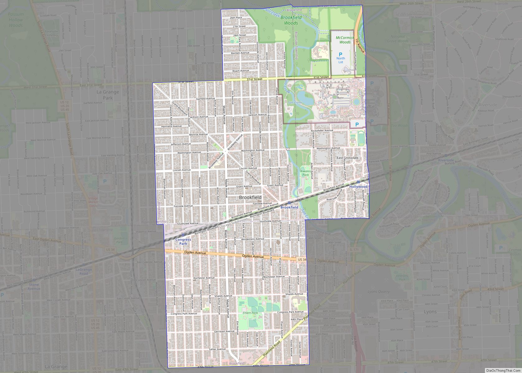
Brookfield (formerly Grossdale) is a village in Cook County, Illinois, United States, located 13 miles (21 km) west of downtown Chicago. Per the 2020 census, the population was 19,476. The city is home to the Brookfield Zoo. Brookfield village overview: Name: Brookfield village LSAD Code: 47 LSAD Description: village (suffix) State: Illinois County: Cook County Incorporated: … Read more

Map of Buda village

Map of Buda village, Illinois

Buda is a village in Bureau County, Illinois, United States. The population was 482 at the 2020 census. It is part of the Ottawa Micropolitan Statistical Area. Buda village overview: Name: Buda village LSAD Code: 47 LSAD Description: village (suffix) State: Illinois County: Bureau County Total Area: 1.01 sq mi (2.63 km²) Land Area: 1.01 sq mi (2.63 km²) Water Area: … Read more

Map of Buckner village, Illinois

Map of Buckner village, Illinois

Buckner is a village in Franklin County, Illinois, United States. The population was 409 at the 2020 census. The current mayor is Aaron Eubanks. Buckner village overview: Name: Buckner village LSAD Code: 47 LSAD Description: village (suffix) State: Illinois County: Franklin County Elevation: 397 ft (121 m) Total Area: 0.89 sq mi (2.31 km²) Land Area: 0.87 sq mi (2.26 km²) Water Area: … Read more

Map of Buckley village

Map of Buckley village, Illinois

Buckley is a village in Artesia Township, Iroquois County, Illinois, United States. The population was 600 at the 2010 census. Buckley celebrated its sesquicentennial in 2006. Buckley village overview: Name: Buckley village LSAD Code: 47 LSAD Description: village (suffix) State: Illinois County: Iroquois County Elevation: 702 ft (214 m) Total Area: 0.32 sq mi (0.82 km²) Land Area: 0.32 sq mi (0.82 km²) … Read more

Map of Burbank city, Illinois

Map of Burbank city, Illinois

Burbank is a city in Cook County, Illinois, United States. The population was 29,439 at the 2020 census. It is located at the southwest edge of the city of Chicago; the Chicago city limit – specifically that of the Ashburn neighborhood – is in common with Burbank’s eastern city limit. Burbank shares a boundary with … Read more

Map of Bunker Hill city

Map of Bunker Hill city, Illinois

Bunker Hill is a city in Macoupin County, Illinois, United States. The population was 1,630 at the 2020 census, down from 1,774 in 2010. Bunker Hill city overview: Name: Bunker Hill city LSAD Code: 25 LSAD Description: city (suffix) State: Illinois County: Macoupin County Elevation: 656 ft (200 m) Total Area: 1.31 sq mi (3.38 km²) Land Area: 1.28 sq mi (3.32 km²) … Read more

Map of Buncombe village

Map of Buncombe village

Buncombe is a village in Johnson County, Illinois, United States. The population was 203 at the 2010 census and as of 2018, the population had declined to an estimated 173. Buncombe village overview: Name: Buncombe village LSAD Code: 47 LSAD Description: village (suffix) State: Illinois County: Johnson County Elevation: 518 ft (158 m) Total Area: 1.20 sq mi (3.11 km²) … Read more

Map of Bulpitt village

Map of Bulpitt village

Bulpitt is a village in Christian County, Illinois, United States. The population was 212 at the 2020 census. Bulpitt village overview: Name: Bulpitt village LSAD Code: 47 LSAD Description: village (suffix) State: Illinois County: Christian County Elevation: 600 ft (200 m) Total Area: 0.07 sq mi (0.18 km²) Land Area: 0.07 sq mi (0.18 km²) Water Area: 0.00 sq mi (0.00 km²) Total Population: 212 Population … Read more

Map of Bull Valley village

Map of Bull Valley village

Bull Valley is a village in McHenry County, Illinois, United States. The population was 1,128 at the 2020 census. Surrounded by the suburban sprawl of Crystal Lake, Woodstock, and McHenry, the village prides itself in its rural, low-density character. Bull Valley village overview: Name: Bull Valley village LSAD Code: 47 LSAD Description: village (suffix) State: … Read more

Map of Buffalo village, Illinois

Map of Buffalo village, Illinois

Buffalo is a village in Mechanicsburg Township in Sangamon County, Illinois, United States. The population was 503 at the 2010 census. It is part of the Springfield, Illinois Metropolitan Statistical Area. Buffalo village overview: Name: Buffalo village LSAD Code: 47 LSAD Description: village (suffix) State: Illinois County: Sangamon County Founded: 1854 Elevation: 611 ft (186 m) Total … Read more

Map of Buffalo Grove village

Map of Buffalo Grove village

Buffalo Grove, officially the Village of Buffalo Grove, is a village in Lake and Cook County, Illinois. A suburb of Chicago, it lies about 30 miles (50 km) northwest of Downtown Chicago. As of the 2020 Census, Buffalo Grove has a population of 43,212. It totals 9.6 square miles (25 km) of land, with the top three-quarters … Read more

Map of Byron city, Illinois

Map of Byron city, Illinois

Byron is a city in Ogle County, Illinois, United States, probably best known as the location of the Byron Nuclear Generating Station, one of the last nuclear power plants commissioned in the United States. Byron is located in Byron Township, along the Rock River. The population was 3,753 at the 2010 census, up from 2,917 … Read more