Map of Byron city, Illinois
Byron is a city in Ogle County, Illinois, United States, probably best known as the location of the Byron Nuclear Generating Station, one of the last nuclear power plants commissioned in the United States. Byron is located in Byron Township, along the Rock River. The population was 3,753 at the 2010 census, up from 2,917 ... Read more
Map of Byron city, Illinois
Map of Butler village, Illinois
Butler is a small village in Montgomery County, Illinois, United States. The population was 164 at the 2020 census. Butler village overview: Name: Butler village LSAD Code: 47 LSAD Description: village (suffix) State: Illinois County: Montgomery County Elevation: 650 ft (200 m) Total Area: 0.60 sq mi (1.54 km²) Land Area: 0.60 sq mi (1.54 km²) Water Area: 0.00 sq mi (0.00 km²) Total Population: 164 ... Read more
Map of Butler village, Illinois
Map of Bushnell city, Illinois
Bushnell is a city in McDonough County, Illinois, United States. The population was 2,718 at the 2020 census, down from 3,117 in 2010. Bushnell city overview: Name: Bushnell city LSAD Code: 25 LSAD Description: city (suffix) State: Illinois County: McDonough County Elevation: 646 ft (197 m) Total Area: 2.13 sq mi (5.50 km²) Land Area: 2.12 sq mi (5.48 km²) Water Area: 0.01 sq mi ... Read more
Map of Bushnell city, Illinois
Map of Bush village
Bush is a village in Williamson County, Illinois, United States. As of the 2000 census, the village population was 257. Bush village overview: Name: Bush village LSAD Code: 47 LSAD Description: village (suffix) State: Illinois County: Williamson County Elevation: 400 ft (100 m) Total Area: 0.46 sq mi (1.19 km²) Land Area: 0.46 sq mi (1.18 km²) Water Area: 0.01 sq mi (0.02 km²) Total Population: ... Read more
Map of Bush village
Map of Burr Ridge village
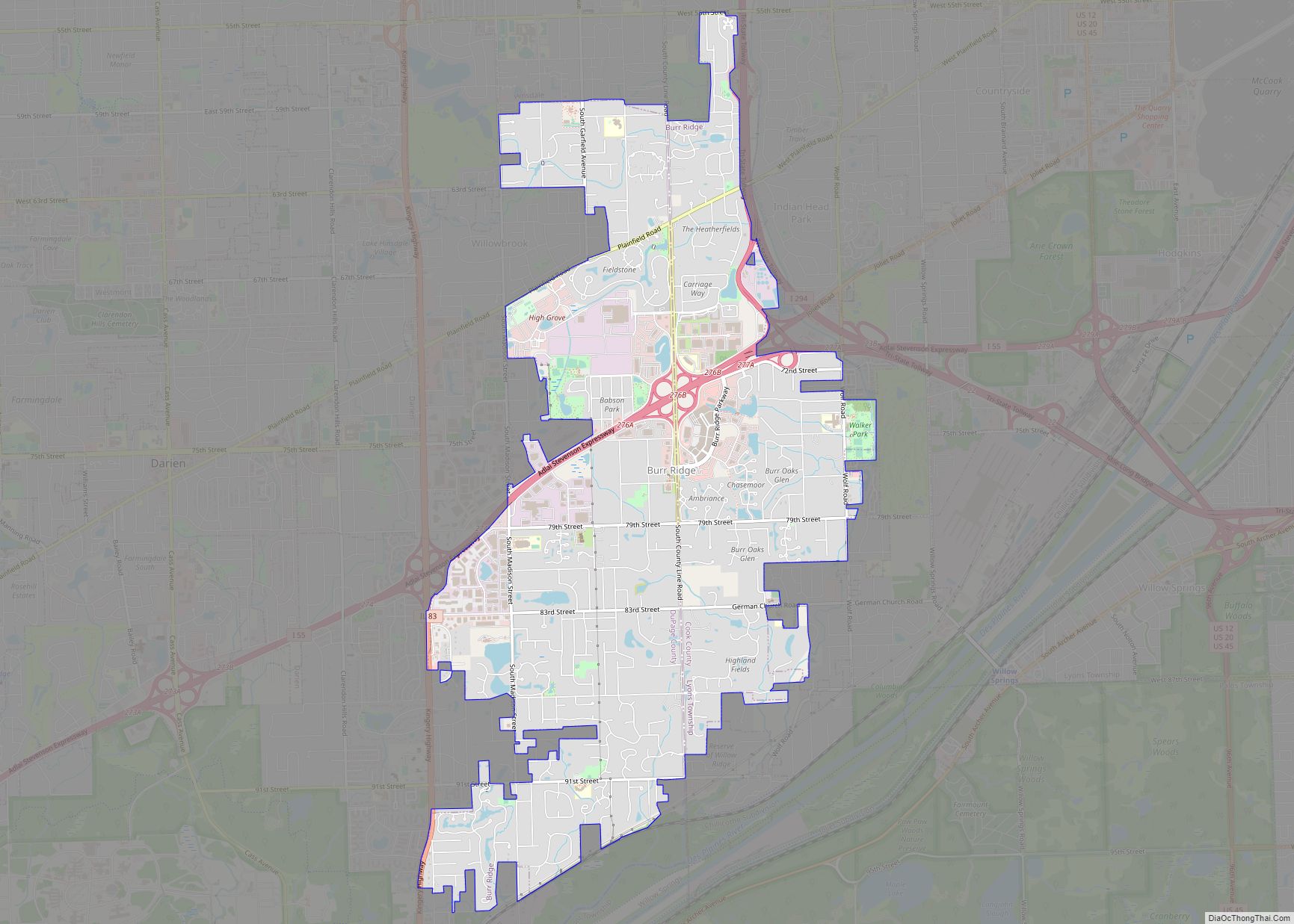
Burr Ridge (formerly Harvester) is a village in Cook and DuPage counties in the U.S. state of Illinois. A suburb of Chicago, it is among the wealthiest towns in Illinois and is locally known for its large, elegant mansions and luxury lifestyles. Per the 2020 census, the population was 11,192. Burr Ridge village overview: Name: ... Read more
Map of Burr Ridge village
Map of Burnt Prairie village
Burnt Prairie (formerly known as Liberty) is a village in White County, Illinois, United States. The population was 58 at the 2000 census. Burnt Prairie village overview: Name: Burnt Prairie village LSAD Code: 47 LSAD Description: village (suffix) State: Illinois County: White County Elevation: 459 ft (140 m) Total Area: 0.08 sq mi (0.20 km²) Land Area: 0.08 sq mi (0.20 km²) Water ... Read more
Map of Burnt Prairie village
Map of Burnham village, Illinois
Burnham is a village in Cook County, Illinois, United States. The population was 4,046 at the 2020 census. The ZIP code is 60633. Burnham has a Chicago ZIP code, and is often mistakenly considered part of Chicago. It is, however, an independent municipality lying just south of the Chicago city limits. Burnham was named for ... Read more
Map of Burnham village, Illinois
Map of Burlington village, Illinois
Burlington is a village in Kane County, Illinois, United States. The population was 535 at the 2020 census, down from 618 in 2010. It was incorporated as a village on November 6, 1990. Burlington village overview: Name: Burlington village LSAD Code: 47 LSAD Description: village (suffix) State: Illinois County: Kane County Founded: 1906 Incorporated: November ... Read more
Map of Burlington village, Illinois
Map of Bureau Junction village
Bureau Junction, usually called Bureau, is a village in Bureau County, Illinois, United States. The population was 281 at the 2020 census. The village name is shown as both “Bureau Junction” and “Bureau” on federal maps, and is commonly called “Bureau”, including by phone companies and the United States Post Office. It is part of ... Read more
Map of Bureau Junction village
Map of Calumet Park village
Calumet Park (formerly DeYoung) is a village in Cook County, Illinois. The population was 7,025 at the 2020 census. On May 13, 2010, Mayor Joseph DuPar and the Village Board approved renaming 127th Street as Obama Drive, in honor of the 44th President of the United States. On August 21, 2010, State Senator Emil Jones ... Read more
Map of Calumet Park village
Map of Calumet City
Calumet City (/ˌkæljʊˈmɛt/ KAL-yuu-MET) is a city in Cook County, Illinois, United States. The population was 36,033 at the 2020 census, a decline of 2.7% from 37,042 in 2010. The ZIP code is 60409. Calumet City city overview: Name: Calumet City city LSAD Code: 25 LSAD Description: city (suffix) State: Illinois County: Cook County Total ... Read more
Map of Calumet City
Map of Calhoun village, Illinois
Calhoun is a village in Richland County, Illinois, United States. The population was 222 at the 2000 census. Calhoun village overview: Name: Calhoun village LSAD Code: 47 LSAD Description: village (suffix) State: Illinois County: Richland County Elevation: 545 ft (166 m) Total Area: 0.91 sq mi (2.36 km²) Land Area: 0.91 sq mi (2.36 km²) Water Area: 0.00 sq mi (0.00 km²) Total Population: 164 Population ... Read more
Map of Calhoun village, Illinois