Map of Crestwood village

Map of Crestwood village, Illinois

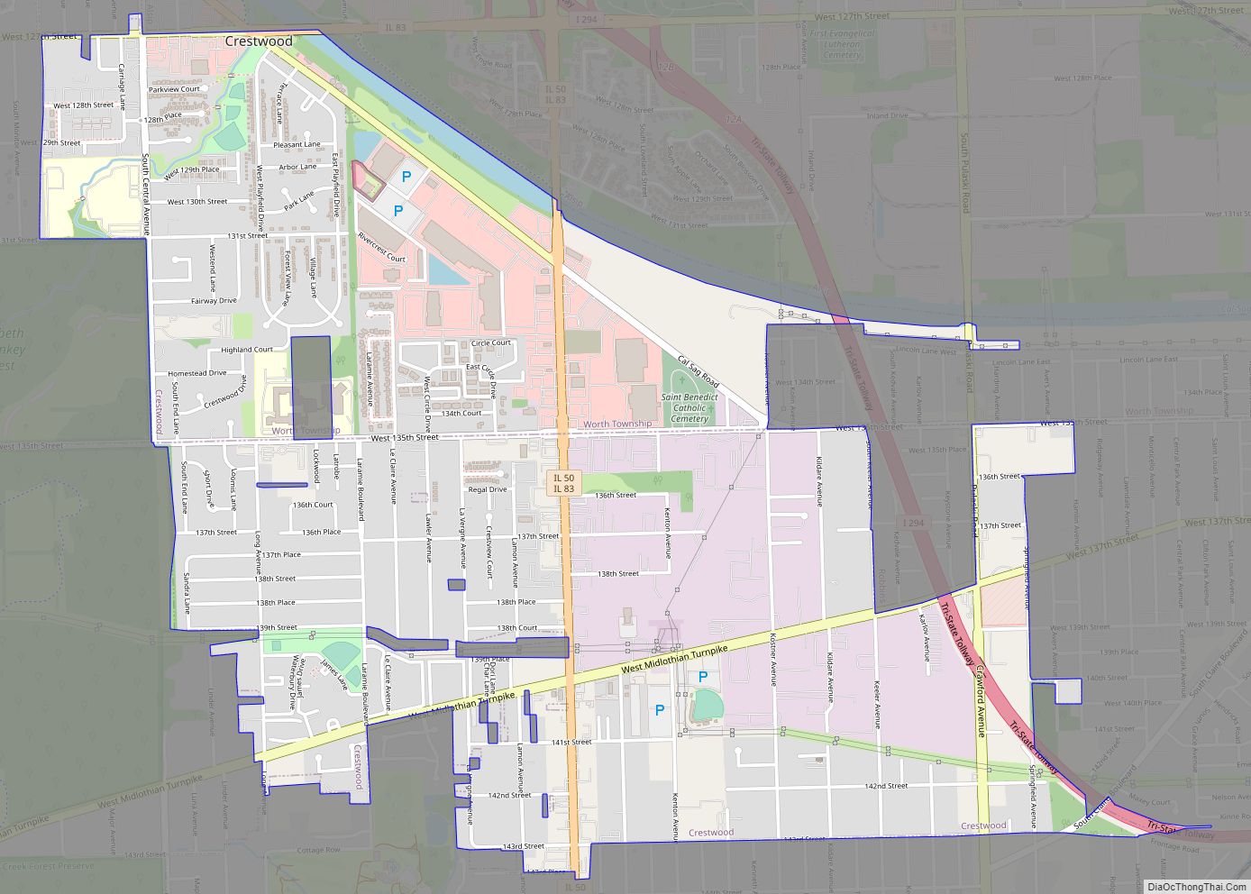
Crestwood is a village about 24 miles southwest of Chicago in Cook County, Illinois, United States. Per the 2020 census, the population was 10,826. The Windy City ThunderBolts of the independent baseball Frontier League play at Ozinga Field in Crestwood. Crestwood village overview: Name: Crestwood village LSAD Code: 47 LSAD Description: village (suffix) State: Illinois … Read more

Map of Creve Coeur village

Map of Creve Coeur village, Illinois

Creve Coeur is a village in Groveland Township, Tazewell County, Illinois, United States. As of the 2020 census, the village population was 4,934. Creve Coeur is a suburb of Peoria and is part of the Peoria, Illinois Metropolitan Statistical Area. Creve Coeur village overview: Name: Creve Coeur village LSAD Code: 47 LSAD Description: village (suffix) … Read more

Map of Crossville village, Illinois

Map of Crossville village, Illinois

Crossville is a village in White County, Illinois, United States. The population was 745 at the 2010 census. Crossville village overview: Name: Crossville village LSAD Code: 47 LSAD Description: village (suffix) State: Illinois County: White County Elevation: 397 ft (121 m) Total Area: 0.64 sq mi (1.66 km²) Land Area: 0.64 sq mi (1.66 km²) Water Area: 0.00 sq mi (0.00 km²) Total Population: 623 Population … Read more

Map of Crystal Lawns CDP

Map of Crystal Lawns CDP

Crystal Lawns is a census-designated place (CDP) in Will County, Illinois, United States. The population was 1,830 at the 2020 census. Crystal Lawns CDP overview: Name: Crystal Lawns CDP LSAD Code: 57 LSAD Description: CDP (suffix) State: Illinois County: Will County Elevation: 604 ft (184 m) Total Area: 0.66 sq mi (1.71 km²) Land Area: 0.66 sq mi (1.71 km²) Water Area: 0.00 sq mi … Read more

Map of Crystal Lake city, Illinois

Map of Crystal Lake city, Illinois

Crystal Lake is a city in McHenry County in the U.S. state of Illinois. Named after a lake 1.6 miles (2.6 km) southwest of the city’s downtown, Crystal Lake is 45 miles northwest of Chicago. The population is 40,269 as of the 2020 Census, a 1.2% decrease from 2010. Crystal Lake is the largest city in … Read more

Map of Cullom village

Map of Cullom village

Cullom is a village in Livingston County, Illinois, United States. Cullom is situated twenty miles east of Pontiac which is the county seat, and is one mile west of the Ford County line. The population was 555 at the 2010 census. Cullom village overview: Name: Cullom village LSAD Code: 47 LSAD Description: village (suffix) State: … Read more

Map of Cuba city, Illinois

Map of Cuba city, Illinois

Cuba is a city in Fulton County, Illinois, United States. The population was 1,294 at the 2010 census, down from 1,418 at the 2000 census. Cuba city overview: Name: Cuba city LSAD Code: 25 LSAD Description: city (suffix) State: Illinois County: Fulton County Founded: 1818 Elevation: 682 ft (208 m) Total Area: 0.54 sq mi (1.41 km²) Land Area: 0.54 sq mi … Read more

Map of Cutler village, Illinois

Map of Cutler village, Illinois

Cutler is a village in Perry County, Illinois, United States. The population was 441 at the 2010 census. Cutler village overview: Name: Cutler village LSAD Code: 47 LSAD Description: village (suffix) State: Illinois County: Perry County Elevation: 499 ft (152 m) Total Area: 0.47 sq mi (1.21 km²) Land Area: 0.47 sq mi (1.21 km²) Water Area: 0.00 sq mi (0.00 km²) Total Population: 361 Population … Read more

Map of Curran village

Map of Curran village

Curran is a village in Curran Township, Sangamon County, Illinois (United States). It was incorporated in 2005 and had an estimated population of 212 in 2010. Curran is located a few miles west of Springfield and is part of the Springfield Metropolitan Statistical Area. Curran village overview: Name: Curran village LSAD Code: 47 LSAD Description: … Read more

Map of Dahlgren village

Map of Dahlgren village, Illinois

Dahlgren is a village in Hamilton County, Illinois, United States. The population was 525 at the 2010 census. It is part of the Mount Vernon Micropolitan Statistical Area. Dahlgren village overview: Name: Dahlgren village LSAD Code: 47 LSAD Description: village (suffix) State: Illinois County: Hamilton County Founded: March 29, 1872 Elevation: 515 ft (157 m) Total Area: … Read more

Map of Cypress village, Illinois

Map of Cypress village, Illinois

Cypress is a village in Johnson County, Illinois, United States. The population was 234 at the 2010 census. Cypress village overview: Name: Cypress village LSAD Code: 47 LSAD Description: village (suffix) State: Illinois County: Johnson County Elevation: 381 ft (116 m) Total Area: 0.76 sq mi (1.96 km²) Land Area: 0.75 sq mi (1.95 km²) Water Area: 0.00 sq mi (0.01 km²) Total Population: 217 Population … Read more

Map of Dallas City city

Map of Dallas City

Dallas City is a city in Hancock and Henderson counties in the U.S. state of Illinois. The population in 2020 stands at an estimate of 805, a decline from the 2010 census of 945, which was a decline from 1,055 in 2000. The Hancock County portion of Dallas City is part of the Fort Madison–Keokuk, … Read more