Map of Elburn village
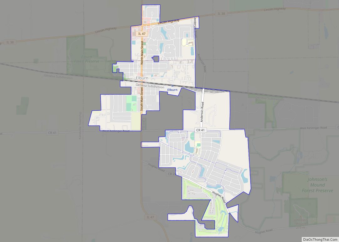
Elburn is a village in Kane County, Illinois, United States. The population was 5,602 as of the 2010 census, up from 2,756 at the 2000 census. It is located at the intersection of Illinois Route 38 and Route 47. Elburn is a town situated 46 miles (74 km) west of the Chicago Loop with frequent commuter ... Read more
Map of Elburn village
Map of Elizabeth village, Illinois
Elizabeth is a village in Jo Daviess County, Illinois, United States. The population was 761 at the 2010 census. Elizabeth village overview: Name: Elizabeth village LSAD Code: 47 LSAD Description: village (suffix) State: Illinois County: Jo Daviess County Elevation: 801 ft (244 m) Total Area: 0.92 sq mi (2.38 km²) Land Area: 0.92 sq mi (2.38 km²) Water Area: 0.00 sq mi (0.00 km²) Total Population: ... Read more
Map of Elizabeth village, Illinois
Map of Eldred village, Illinois
Eldred is a village in Greene County, Illinois, United States. The population was 201 at the 2010 census. Eldred village overview: Name: Eldred village LSAD Code: 47 LSAD Description: village (suffix) State: Illinois County: Greene County Elevation: 446 ft (136 m) Total Area: 0.13 sq mi (0.35 km²) Land Area: 0.13 sq mi (0.35 km²) Water Area: 0.00 sq mi (0.00 km²) Total Population: 149 Population ... Read more
Map of Eldred village, Illinois
Map of Elk Grove Village village
Elk Grove Village is a village in Cook and DuPage counties in the U.S. state of Illinois. Per the 2020 census, the population was 32,812. Located 20 miles (32 km) northwest of Chicago along the Golden Corridor, the Village of Elk Grove Village was incorporated on July 17, 1956. It is directly adjacent to O’Hare International ... Read more
Map of Elk Grove Village village
Map of Elizabethtown village, Illinois
Elizabethtown is a village in and the county seat of Hardin County, Illinois, United States, along the Ohio River. The population was 299 at the 2010 census, down from 348 at the 2000 census. It is the least-populous county seat in the state. Elizabethtown village overview: Name: Elizabethtown village LSAD Code: 47 LSAD Description: village ... Read more
Map of Elizabethtown village, Illinois
Map of Elkville village
Elkville is a village in Jackson County, Illinois, United States. The population was 928 at the 2010 census, down from 1,001 at the 2000 census. As of 2018 the estimated population was 871. Elkville village overview: Name: Elkville village LSAD Code: 47 LSAD Description: village (suffix) State: Illinois County: Jackson County Elevation: 400 ft (100 m) Total ... Read more
Map of Elkville village
Map of Elkhart village, Illinois
Elkhart is a village in Logan County, Illinois, United States. The population was 405 at the 2010 census. Elkhart village overview: Name: Elkhart village LSAD Code: 47 LSAD Description: village (suffix) State: Illinois County: Logan County Elevation: 640 ft (200 m) Total Area: 1.95 sq mi (5.05 km²) Land Area: 1.94 sq mi (5.03 km²) Water Area: 0.01 sq mi (0.02 km²) Total Population: 450 Population ... Read more
Map of Elkhart village, Illinois
Map of Ellis Grove village
Ellis Grove is a village in Randolph County, Illinois, United States. The population was 328 at the 2020 census. Ellis Grove village overview: Name: Ellis Grove village LSAD Code: 47 LSAD Description: village (suffix) State: Illinois County: Randolph County Total Area: 0.49 sq mi (1.28 km²) Land Area: 0.49 sq mi (1.27 km²) Water Area: 0.00 sq mi (0.00 km²) Total Population: 328 Population ... Read more
Map of Ellis Grove village
Map of Elliott village, Illinois
Elliott is a village in Ford County, Illinois, United States. The population was 295 at the 2010 census. Elliott village overview: Name: Elliott village LSAD Code: 47 LSAD Description: village (suffix) State: Illinois County: Ford County Elevation: 781 ft (238 m) Total Area: 0.50 sq mi (1.29 km²) Land Area: 0.50 sq mi (1.29 km²) Water Area: 0.00 sq mi (0.00 km²) Total Population: 274 Population ... Read more
Map of Elliott village, Illinois
Map of Ellsworth village, Illinois
Ellsworth is a village in Dawson Township, McLean County, Illinois, United States. The population was 184 at the 2020 census. It is part of the Bloomington–Normal Metropolitan Statistical Area. Ellsworth village overview: Name: Ellsworth village LSAD Code: 47 LSAD Description: village (suffix) State: Illinois County: McLean County Elevation: 866 ft (264 m) Total Area: 0.22 sq mi (0.56 km²) Land ... Read more
Map of Ellsworth village, Illinois
Map of Ellisville village, Illinois
Ellisville is a village in Fulton County, Illinois, United States. The population was 96 at the 2010 census. Ellisville village overview: Name: Ellisville village LSAD Code: 47 LSAD Description: village (suffix) State: Illinois County: Fulton County Elevation: 545 ft (166 m) Total Area: 0.27 sq mi (0.70 km²) Land Area: 0.27 sq mi (0.70 km²) Water Area: 0.00 sq mi (0.00 km²) Total Population: 87 Population ... Read more
Map of Ellisville village, Illinois
Map of Elmwood Park village, Illinois
Elmwood Park is a village in Cook County, Illinois, United States. The population was 24,521 at the 2020 census. The community has long maintained a large Italian-American population, with a more recent influx of Polish-American and Hispanic residents. Elmwood Park village overview: Name: Elmwood Park village LSAD Code: 47 LSAD Description: village (suffix) State: Illinois ... Read more
Map of Elmwood Park village, Illinois