Map of Elmhurst city
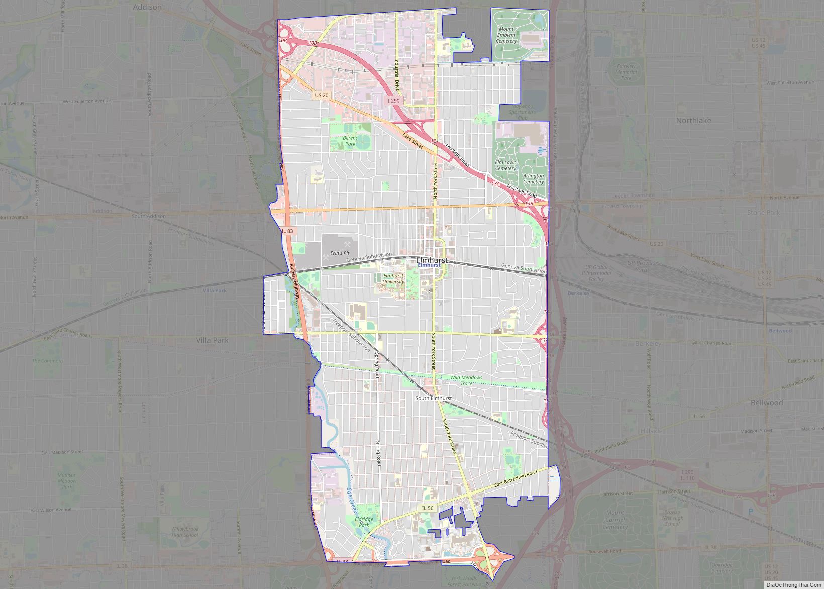
Elmhurst is a city mostly in DuPage County and overlapping into Cook County in the U.S. state of Illinois, and a western suburb of Chicago. Elmhurst city overview: Name: Elmhurst city LSAD Code: 25 LSAD Description: city (suffix) State: Illinois County: Cook County, DuPage County Incorporated: June 5, 1882 (1882-06-05) Elevation: 686 ft (209 m) Total Area: 10.28 sq mi (26.62 km²) Land ... Read more
Map of Elmhurst city
Map of Elsah village
Elsah is a village in Jersey County, Illinois. As of the 2020 census, the village had a total population of 519. Michael Pitchford is the village’s current acting mayor. It is the home of Principia College. Elsah is a part of the Metro-East region and the St. Louis Metropolitan Statistical Area. Elsah village overview: Name: ... Read more
Map of Elsah village
Map of Elmwood city, Illinois
Elmwood is a city in Peoria County, Illinois, United States. The population was 2,097 at the 2010 census. Elmwood is part of the Peoria, Illinois Metropolitan Statistical Area. Elmwood city overview: Name: Elmwood city LSAD Code: 25 LSAD Description: city (suffix) State: Illinois County: Peoria County Total Area: 1.40 sq mi (3.62 km²) Land Area: 1.40 sq mi (3.62 km²) Water ... Read more
Map of Elmwood city, Illinois
Map of Elwood village, Illinois
Elwood is a village in rural Will County, Illinois, United States, approximately 40 miles southwest of Chicago. The population was 2,229 at the 2020 United States Census, down from 2,279 in 2010. Elwood village overview: Name: Elwood village LSAD Code: 47 LSAD Description: village (suffix) State: Illinois County: Will County Elevation: 646 ft (197 m) Total Area: ... Read more
Map of Elwood village, Illinois
Map of Elvaston village
Elvaston is a village in Hancock County, Illinois, United States. The population was 165 at the 2010 census, an increase from 152 in 2000. Elvaston village overview: Name: Elvaston village LSAD Code: 47 LSAD Description: village (suffix) State: Illinois County: Hancock County Elevation: 659 ft (201 m) Total Area: 0.80 sq mi (2.07 km²) Land Area: 0.80 sq mi (2.07 km²) Water Area: ... Read more
Map of Elvaston village
Map of Emington village
Emington is a village in Livingston County, Illinois, United States. The population was 117 at the 2010 census. Emington village overview: Name: Emington village LSAD Code: 47 LSAD Description: village (suffix) State: Illinois County: Livingston County Elevation: 709 ft (216 m) Total Area: 0.08 sq mi (0.21 km²) Land Area: 0.08 sq mi (0.21 km²) Water Area: 0.00 sq mi (0.00 km²) Total Population: 101 Population ... Read more
Map of Emington village
Map of Emden village
Emden is a village in Logan County, Illinois, United States. The population was 485 at the 2010 census. The village was named after Emden, Germany due to the large number of residents who immigrated to the area from villages along the River Ems[1] The first newspaper published in Emden was The Emden Star in 1893. ... Read more
Map of Emden village
Map of Enfield village, Illinois
Enfield is a village in White County, Illinois, United States. The population was 596 at the 2010 census. Enfield village overview: Name: Enfield village LSAD Code: 47 LSAD Description: village (suffix) State: Illinois County: White County Elevation: 479 ft (146 m) Total Area: 1.01 sq mi (2.62 km²) Land Area: 1.01 sq mi (2.62 km²) Water Area: 0.00 sq mi (0.00 km²) Total Population: 794 Population ... Read more
Map of Enfield village, Illinois
Map of Energy village
Energy is a village in Williamson County, Illinois, United States. The population was 1,146 at the 2010 census. The community was named for local “Energy” brand coal. Energy village overview: Name: Energy village LSAD Code: 47 LSAD Description: village (suffix) State: Illinois County: Williamson County Elevation: 459 ft (140 m) Total Area: 1.21 sq mi (3.14 km²) Land Area: 1.19 sq mi ... Read more
Map of Energy village
Map of Erie village, Illinois
Erie is a village in Whiteside County, Illinois, United States. The population was 1,602 at the 2010 census, up from 1,589 in 2000. It is known for its unusual layout, specifically its “town triangle”. Erie village overview: Name: Erie village LSAD Code: 47 LSAD Description: village (suffix) State: Illinois County: Whiteside County Total Area: 1.39 sq mi ... Read more
Map of Erie village, Illinois
Map of Equality village
Equality is a village in Gallatin County, Illinois, United States. The population was 595 at the 2010 census, down from 721 at the 2000 census. Near the village are two points of interest, the Crenshaw House and the Garden of the Gods Wilderness. Equality was the county seat of Gallatin County from 1826–1851. Equality village ... Read more
Map of Equality village
Map of Eureka city, Illinois
Eureka is a city and the county seat of Woodford County, Illinois. The population was 5,295 at the 2010 census. Eureka is part of the Peoria, Illinois Metropolitan Statistical Area. Eureka is a small community centered on the intersection of what is now U.S. 24 and Illinois 117. It is also one of the towns ... Read more
Map of Eureka city, Illinois