Map of Hurst city

Map of Hurst city, Illinois

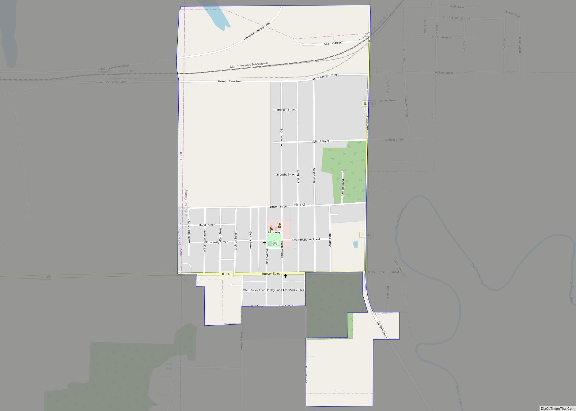
Hurst is a city in Williamson County, Illinois, United States. The population was 795 at the 2010 census. Hurst city overview: Name: Hurst city LSAD Code: 25 LSAD Description: city (suffix) State: Illinois County: Williamson County Founded: 1903 Elevation: 394 ft (120 m) Total Area: 0.89 sq mi (2.31 km²) Land Area: 0.89 sq mi (2.30 km²) Water Area: 0.01 sq mi (0.02 km²) Total Population: … Read more

Map of Ina village

Map of Ina village

Ina is a village in Jefferson County, Illinois, United States. The population was 2,338 as of the 2010 census. It is part of the Mount Vernon Micropolitan Statistical Area. Ina village overview: Name: Ina village LSAD Code: 47 LSAD Description: village (suffix) State: Illinois County: Jefferson County Elevation: 427 ft (130 m) Total Area: 2.40 sq mi (6.23 km²) Land … Read more

Map of Illiopolis village

Map of Illiopolis village

Illiopolis is a village in Sangamon County, Illinois, United States. The population was 891 at the 2010 census. It is part of the Springfield, Illinois Metropolitan Statistical Area. Illiopolis village overview: Name: Illiopolis village LSAD Code: 47 LSAD Description: village (suffix) State: Illinois County: Sangamon County Elevation: 601 ft (183 m) Total Area: 0.68 sq mi (1.75 km²) Land Area: … Read more

Map of Indian Head Park village

Map of Indian Head Park village

Indian Head Park is a village in Cook County, Illinois, United States, slightly north of the intersection of Interstate 294 and Interstate 55. The village is south of Western Springs, west of Countryside, north and east of Burr Ridge. Per the 2020 census, the population was 4,065. The village’s ZIP code is 60525 (La Grange). … Read more

Map of Indian Creek village, Illinois

Map of Indian Creek village, Illinois

Indian Creek is a village in Vernon Township, Lake County, Illinois, United States. It is part of the Chicago metropolitan area. Per the 2020 census, the population was 536. Police services are provided by Lake County Sheriff and fire/EMS services by the Countryside Fire Protection District. Indian Creek village overview: Name: Indian Creek village LSAD … Read more

Map of Industry village, Illinois

Map of Industry village, Illinois

Industry is a village in McDonough County, Illinois, United States. As of the 2020 census, the village population was 399, down from 478 in 2010. Industry village overview: Name: Industry village LSAD Code: 47 LSAD Description: village (suffix) State: Illinois County: McDonough County Elevation: 658 ft (201 m) Total Area: 0.46 sq mi (1.19 km²) Land Area: 0.46 sq mi (1.19 km²) Water … Read more

Map of Indianola village, Illinois

Map of Indianola village, Illinois

Indianola is a village in Carroll Township, Vermilion County, Illinois, United States. It is part of the Danville, Illinois Metropolitan Statistical Area. The population was 207 at the 2000 census. Indianola village overview: Name: Indianola village LSAD Code: 47 LSAD Description: village (suffix) State: Illinois County: Vermilion County Elevation: 673 ft (205 m) Total Area: 0.39 sq mi (1.01 km²) … Read more

Map of Inverness village, Illinois

Map of Inverness village, Illinois

Inverness is a suburban village in Cook County, Illinois, United States. Per the 2020 census, the population was 7,616. Inverness village overview: Name: Inverness village LSAD Code: 47 LSAD Description: village (suffix) State: Illinois County: Cook County Total Area: 6.69 sq mi (17.33 km²) Land Area: 6.53 sq mi (16.92 km²) Water Area: 0.15 sq mi (0.40 km²) Total Population: 7,616 Population Density: 1,165.60/sq mi … Read more

Map of Ingalls Park CDP

Map of Ingalls Park CDP

Ingalls Park is a census-designated place and suburb of Joliet in Will County, Illinois, United States. The population was 3,314 at the 2010 census. The town consists of a small neighborhood and a few businesses between Joliet’s Pilcher Park and Interstate 80. It is the nearest town to Chicagoland Speedway, which hosted the NASCAR Cup … Read more

Map of Ipava village

Map of Ipava village

Ipava is a village in Fulton County, Illinois, United States. The population was 470 at the 2010 census. Ipava village overview: Name: Ipava village LSAD Code: 47 LSAD Description: village (suffix) State: Illinois County: Fulton County Elevation: 656 ft (200 m) Total Area: 0.27 sq mi (0.69 km²) Land Area: 0.27 sq mi (0.69 km²) Water Area: 0.00 sq mi (0.00 km²) Total Population: 447 Population … Read more

Map of Iola village

Map of Iola village, Illinois

Iola is a village in Clay County, Illinois, United States. The population was 98 at the 2020 census. Iola village overview: Name: Iola village LSAD Code: 47 LSAD Description: village (suffix) State: Illinois County: Clay County Total Area: 0.96 sq mi (2.50 km²) Land Area: 0.96 sq mi (2.50 km²) Water Area: 0.00 sq mi (0.00 km²) Total Population: 98 Population Density: 101.66/sq mi (39.24/km²) … Read more

Map of Irving city

Map of Irving village, Illinois

Irving is a village in Montgomery County, Illinois, United States. The population was 373 at the 2020 census, down from 495 in 2010. Irving village overview: Name: Irving village LSAD Code: 47 LSAD Description: village (suffix) State: Illinois County: Montgomery County Elevation: 656 ft (200 m) Total Area: 0.90 sq mi (2.32 km²) Land Area: 0.90 sq mi (2.32 km²) Water Area: 0.00 sq mi … Read more