Map of Lawrenceville city, Illinois

Map of Lawrenceville city, Illinois

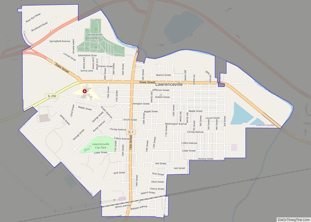
Lawrenceville is a city in and the county seat of Lawrence County, Illinois, United States, located along the Embarras River. The population was 4,348 at the 2010 census. Lawrenceville is located in southeast Illinois, northwest of Vincennes, Indiana. The city is home of the Lawrenceville “Indians”, Illinois Class A high school state basketball champions in … Read more

Map of Lebanon city

Map of Lebanon city, Illinois

Lebanon is a city in St. Clair County, Illinois, United States. The population was 4,418 at the 2010 census and had decreased to an estimated 4,256 as of 2018. Like many other places in “Little Egypt” or Southern Illinois, Lebanon was named after the Eastern Mediterranean country of the same name. It is a part … Read more

Map of Leaf River village

Map of Leaf River village

Leaf River is a village in Leaf River Township, Ogle County, Illinois, United States, along a stream of the same name. The population was 443 at the 2010 census, down from 555 in 2000. Leaf River village overview: Name: Leaf River village LSAD Code: 47 LSAD Description: village (suffix) State: Illinois County: Ogle County Elevation: … Read more

Map of Leland Grove city

Map of Leland Grove city

Leland Grove is a city in Sangamon County, Illinois, United States, located adjacent to Springfield. It is part of the Springfield Metropolitan Statistical Area. The population was 1,503 at the 2010 census. Leland Grove city overview: Name: Leland Grove city LSAD Code: 25 LSAD Description: city (suffix) State: Illinois County: Sangamon County Elevation: 564 ft (172 m) … Read more

Map of Lee village, Illinois

Map of Lee village, Illinois

Lee is a village in DeKalb County and Lee County, Illinois, United States. The population was 313 at the 2020 census. Lee village overview: Name: Lee village LSAD Code: 47 LSAD Description: village (suffix) State: Illinois County: DeKalb County, Lee County Total Area: 0.20 sq mi (0.51 km²) Land Area: 0.20 sq mi (0.51 km²) Water Area: 0.00 sq mi (0.00 km²) Total Population: … Read more

Map of Lemont village

Map of Lemont village, Illinois

Lemont is a village located in Cook, DuPage, and Will counties in the U.S. state of Illinois, and is a south-west suburb of Chicago. The population was 17,629 as of the 2020 census. The village is situated on a hillside along the south banks of the Des Plaines River. It overlooks Waterfall Glen’s Midwestern Bluff … Read more

Map of Leland village, Illinois

Map of Leland village, Illinois

Leland is a village in LaSalle County, Illinois, United States. The population was 951 at the 2020 census. It is part of the Ottawa Micropolitan Statistical Area. Leland village overview: Name: Leland village LSAD Code: 47 LSAD Description: village (suffix) State: Illinois County: LaSalle County Incorporated: 1859 Elevation: 696 ft (212 m) Total Area: 0.53 sq mi (1.38 km²) Land … Read more

Map of Lenzburg village

Map of Lenzburg village

Lenzburg is a village in St. Clair County, Illinois, USA. The population was 521 at the 2010 census. Lenzburg village overview: Name: Lenzburg village LSAD Code: 47 LSAD Description: village (suffix) State: Illinois County: St. Clair County Elevation: 443 ft (135 m) Total Area: 1.26 sq mi (3.27 km²) Land Area: 1.16 sq mi (2.99 km²) Water Area: 0.11 sq mi (0.28 km²) Total Population: 468 … Read more

Map of Lena village

Map of Lena village, Illinois

Lena is a village in Stephenson County, Illinois. The population was 2,772 at the 2020 census. Lena was platted in 1853, and named after a place mentioned in a poem by Ossian. Lena village overview: Name: Lena village LSAD Code: 47 LSAD Description: village (suffix) State: Illinois County: Stephenson County Founded: 1834 Elevation: 948 ft (289 m) … Read more

Map of Lerna village

Map of Lerna village

Lerna is a village in Coles County, Illinois, United States. The population was 226 at the 2020 census. It is part of the Charleston–Mattoon Micropolitan Statistical Area. Thomas Lincoln, father of President Abraham Lincoln, spent the later part of his life on a homestead a few miles away, preserved today as the Lincoln Log Cabin … Read more

Map of Leonore village

Map of Leonore village

Leonore is a village in LaSalle County, Illinois, United States. The population was 121 at the 2020 census. It is part of the Ottawa Micropolitan Statistical Area. Leonore village overview: Name: Leonore village LSAD Code: 47 LSAD Description: village (suffix) State: Illinois County: LaSalle County Incorporated: April 20, 1891 Elevation: 679 ft (207 m) Total Area: 0.09 sq mi … Read more

Map of Lexington city, Illinois

Map of Lexington city, Illinois

Lexington is a city in McLean County, Illinois, United States. The population was 2,090 at the 2020 census. There are two theories regarding the etymology of the city name. One says it was named for the Battle of Lexington, where General Gridley’s father fought. and the other that it was named for the home town … Read more