Map of Pearl City village, Illinois

Map of Pearl City village, Illinois

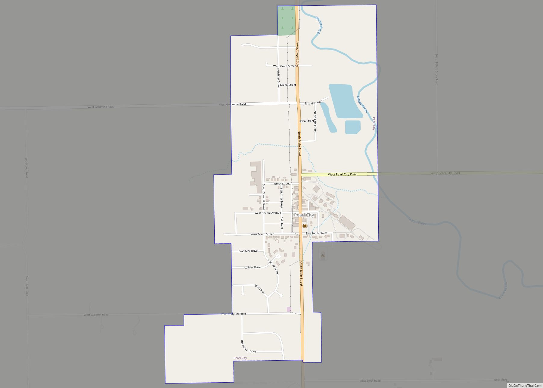
Pearl City is an incorporated village in Stephenson County, Illinois, with a population of 838 at the 2010 census, up from 780 in 2000. Pearl City village overview: Name: Pearl City village LSAD Code: 47 LSAD Description: village (suffix) State: Illinois County: Stephenson County Founded: March 21, 1893 Elevation: 833 ft (254 m) Total Area: 0.65 sq mi (1.68 km²) … Read more

Map of Pekin city

Map of Pekin city, Illinois

Pekin (/ˈpiːkɪn/) is a city in and the county seat of Tazewell County in the U.S. state of Illinois. Located on the Illinois River, Pekin is the largest city of Tazewell County and the second most populous municipality of the Peoria metropolitan area, after Peoria itself. As of the 2020 census, its population is 31,731. … Read more

Map of Pecatonica village

Map of Pecatonica village

Pecatonica is a village in Winnebago County, Illinois, United States. It is part of the Rockford, Illinois Metropolitan Statistical Area. The population was 2,195 at the 2010 census, up from 1,997 in 2000. Pecatonica village overview: Name: Pecatonica village LSAD Code: 47 LSAD Description: village (suffix) State: Illinois County: Winnebago County Elevation: 771 ft (235 m) Total … Read more

Map of Peoria Heights village

Map of Peoria Heights village

Peoria Heights is a village lying almost entirely in Peoria County in the U.S. state of Illinois. The population was 6,156 at the 2010 census, down from 6,635 in 2000. Peoria Heights is a suburb of Peoria, is sometimes referred to as Uptown, and is surrounded by the city except for its eastern boundary on … Read more

Map of Penfield CDP

Map of Penfield CDP

Penfield is an unincorporated census-designated place in Compromise Township, Champaign County, Illinois, United States. Its population was 151 at the 2020 census. Penfield CDP overview: Name: Penfield CDP LSAD Code: 57 LSAD Description: CDP (suffix) State: Illinois County: Champaign County Elevation: 712 ft (217 m) Total Area: 0.26 sq mi (0.67 km²) Land Area: 0.26 sq mi (0.67 km²) Water Area: 0.00 sq mi (0.00 km²) … Read more

Map of Percy village

Map of Percy village

Percy is a village in Randolph County, Illinois, United States. The population was 970 at the 2010 census. Percy village overview: Name: Percy village LSAD Code: 47 LSAD Description: village (suffix) State: Illinois County: Randolph County Total Area: 0.99 sq mi (2.57 km²) Land Area: 0.98 sq mi (2.54 km²) Water Area: 0.01 sq mi (0.03 km²) Total Population: 906 Population Density: 924.49/sq mi (356.95/km²) … Read more

Map of Peotone village

Map of Peotone village

Peotone (/ˈpiːoʊtoʊn/) is a village in Will County, Illinois, United States. The population was 4,142 at the 2010 census, an increase from 3,385 in 2000. The city is about 43 miles (69 km) south of Chicago. The village is home to the Peotone High School Blue Devils. Peotone village overview: Name: Peotone village LSAD Code: 47 … Read more

Map of Peru city

Map of Peru city, Illinois

Peru is a city in LaSalle County, Illinois, United States. The population was 9,896 at the 2020 census, down from 10,295 at the 2010 census. It is part of the Ottawa, IL Micropolitan Statistical Area. Peru and its twin city, LaSalle, make up the core of Illinois Valley. Peru city overview: Name: Peru city LSAD … Read more

Map of Perry village, Illinois

Map of Perry village, Illinois

Perry is a village in Pike County, Illinois, United States. The population was 397 at the 2010 census. Perry village overview: Name: Perry village LSAD Code: 47 LSAD Description: village (suffix) State: Illinois County: Pike County Elevation: 587 ft (179 m) Total Area: 0.39 sq mi (1.00 km²) Land Area: 0.39 sq mi (1.00 km²) Water Area: 0.00 sq mi (0.00 km²) Total Population: 314 Population … Read more

Map of Petersburg city, Illinois

Map of Petersburg city, Illinois

Petersburg is a city in and the county seat of Menard County, Illinois, United States, on the bluffs and part of the floodplain overlooking the Sangamon River. It is part of the Springfield, Illinois Metropolitan Statistical Area. The population was 2,258 at the 2020 census, nearly unchanged from 2010. Petersburg is located approximately 2 miles … Read more

Map of Pesotum village

Map of Pesotum village

Pesotum is a village in Champaign County, Illinois, United States. The population was 551 at the 2010 census. The village was named after Pesotum, a Native American warrior in the Battle of Fort Dearborn. Pesotum village overview: Name: Pesotum village LSAD Code: 47 LSAD Description: village (suffix) State: Illinois County: Champaign County Elevation: 714 ft (218 m) … Read more

Map of Philo village, Illinois

Map of Philo village, Illinois

Philo is a village about nine miles south of Urbana in Champaign County, Illinois, United States. The population was 1,392 at the 2020 census. Philo village overview: Name: Philo village LSAD Code: 47 LSAD Description: village (suffix) State: Illinois County: Champaign County Elevation: 733 ft (223 m) Total Area: 0.83 sq mi (2.15 km²) Land Area: 0.83 sq mi (2.15 km²) Water Area: … Read more