Map of Roodhouse city

Map of Roodhouse city

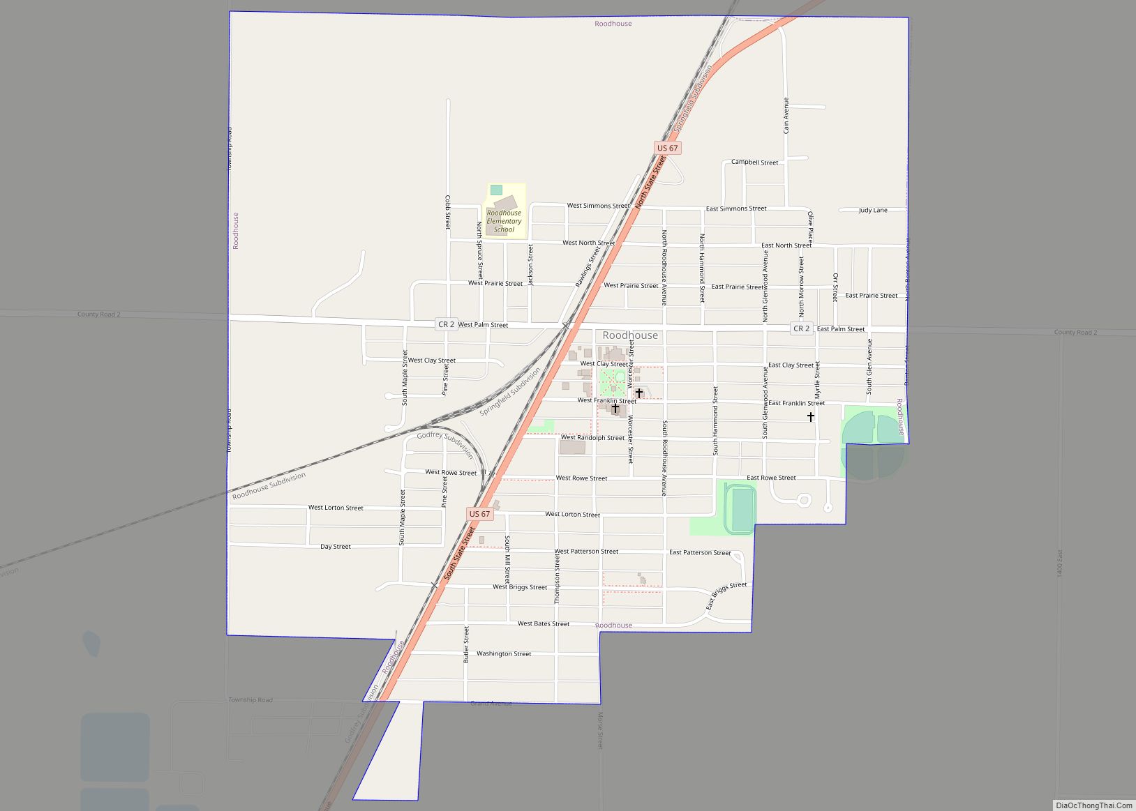
Roodhouse is a city in Greene County, Illinois, United States. The population was 1,814 at the 2010 census, down from 2,214 at the 2000 census. Roodhouse city overview: Name: Roodhouse city LSAD Code: 25 LSAD Description: city (suffix) State: Illinois County: Greene County Elevation: 653 ft (199 m) Total Area: 1.13 sq mi (2.92 km²) Land Area: 1.13 sq mi (2.92 km²) Water … Read more

Map of Roselle village

Map of Roselle village, Illinois

Roselle is a suburb of Chicago and is a village located in both DuPage County and Cook in Illinois. Roselle was first incorporated in 1922 as a bedroom community, with its train stop attracting residents commuting to Chicago or nearby suburbs for their jobs. As of the 2020 census, the village’s population was 22,897. Roselle … Read more

Map of Rose Hill village, Illinois

Map of Rose Hill village, Illinois

Rose Hill is a village in Jasper County, Illinois, United States. The population was 80 at the 2010 census. Rose Hill village overview: Name: Rose Hill village LSAD Code: 47 LSAD Description: village (suffix) State: Illinois County: Jasper County Elevation: 564 ft (172 m) Total Area: 0.63 sq mi (1.64 km²) Land Area: 0.63 sq mi (1.64 km²) Water Area: 0.00 sq mi (0.00 km²) Total … Read more

Map of Roseville village, Illinois

Map of Roseville village, Illinois

Roseville is a village in Warren County, Illinois, United States. The population was 989 at the 2010 census. It is part of the Galesburg Micropolitan Statistical Area. Roseville village overview: Name: Roseville village LSAD Code: 47 LSAD Description: village (suffix) State: Illinois County: Warren County Elevation: 742 ft (226 m) Total Area: 0.74 sq mi (1.91 km²) Land Area: 0.74 sq mi … Read more

Map of Rosemont village, Illinois

Map of Rosemont village, Illinois

Rosemont is a village in Cook County, Illinois, located immediately northwest of Chicago. as of the 2020 census, the village had a population of 3,952. The village was incorporated in 1956, though it had been settled long before that. While Rosemont’s land area and population are relatively small among municipalities in the Chicago Metropolitan Area, … Read more

Map of Rosiclare city

Map of Rosiclare city

Rosiclare is a city in Hardin County, Illinois, along the Ohio River. The population was 1,160 at the 2010 census, down from 1,213 at the 2000 census. Rosiclare city overview: Name: Rosiclare city LSAD Code: 25 LSAD Description: city (suffix) State: Illinois County: Hardin County Elevation: 367 ft (112 m) Total Area: 2.12 sq mi (5.48 km²) Land Area: 1.94 sq mi … Read more

Map of Rosewood Heights CDP

Map of Rosewood Heights CDP

Rosewood Heights is an unincorporated community and census-designated place (CDP) in Madison County, Illinois, United States. The population was 3,971 at the 2020 census. It is part of the Metro East region of the Greater St. Louis metropolitan area. Rosewood Heights CDP overview: Name: Rosewood Heights CDP LSAD Code: 57 LSAD Description: CDP (suffix) State: … Read more

Map of Round Lake Beach village

Map of Round Lake Beach village

Round Lake Beach is a northern suburb of Chicago in Lake County, Illinois, United States. Per the 2020 census, the population was 27,252. The United States Census Bureau defines an urban area of northwest Chicago-area suburbs that are separated from Chicago’s urban area, with Round Lake Beach as the principal city: the Round Lake Beach–McHenry–Grayslake, … Read more

Map of Rossville village, Illinois

Map of Rossville village, Illinois

Rossville is a village in Ross Township, Vermilion County, Illinois, United States. As of the 2020 census, the city population was 1,221. It is part of the Danville, Illinois Metropolitan Statistical Area. Rossville village overview: Name: Rossville village LSAD Code: 47 LSAD Description: village (suffix) State: Illinois County: Vermilion County Founded: 1862 Elevation: 679 ft (207 m) … Read more

Map of Round Lake Park village

Map of Round Lake Park village

Round Lake Park is a village in Lake County, Illinois, United States. Per the 2020 census, the population was 7,680. It is located along the south side of the lake, Round Lake. Access to the lake from this town is private and only for residents of Round Lake Park. Round Lake Park village overview: Name: … Read more

Map of Round Lake Heights village

Map of Round Lake Heights village

Round Lake Heights is a village in Lake County, Illinois, United States. Per the 2020 census, the population was 2,622. Round Lake Heights village overview: Name: Round Lake Heights village LSAD Code: 47 LSAD Description: village (suffix) State: Illinois County: Lake County Total Area: 0.63 sq mi (1.63 km²) Land Area: 0.57 sq mi (1.49 km²) Water Area: 0.05 sq mi (0.14 km²) Total … Read more

Map of Roxana village

Map of Roxana village

Roxana is a village in Madison County, Illinois, United States. The population was 1,454 at the 2020 census. The ZIP Code is 62084. A majority of the land in Roxana is taken up by the Wood River Refinery, an oil refinery operated by Phillips 66. The refinery was originally built and owned by Shell Oil. … Read more