Map of Round Lake village

Map of Round Lake village, Illinois

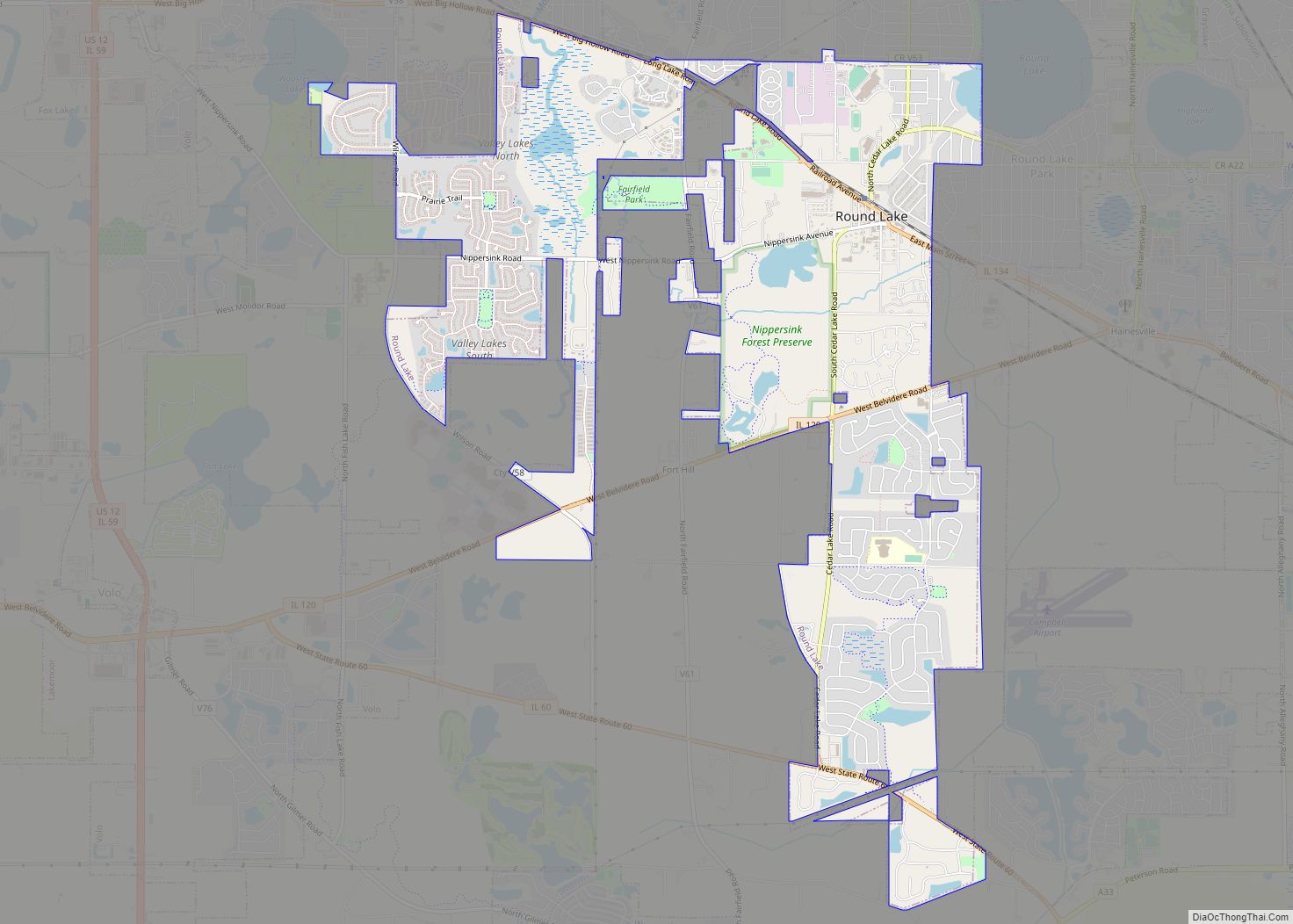
Round Lake is a northern suburb of Chicago in Lake County, Illinois, United States. Per the 2020 census, the population was 18,721. Round Lake village overview: Name: Round Lake village LSAD Code: 47 LSAD Description: village (suffix) State: Illinois County: Lake County Founded: 1908 Total Area: 5.72 sq mi (14.81 km²) Land Area: 5.56 sq mi (14.40 km²) Water Area: 0.16 sq mi … Read more

Map of Royal village, Illinois

Map of Royal village, Illinois

Royal is a village in Champaign County, Illinois, United States. The population was 293 at the 2020 census. Royal village overview: Name: Royal village LSAD Code: 47 LSAD Description: village (suffix) State: Illinois County: Champaign County Founded: 1882 Elevation: 684 ft (208 m) Total Area: 0.18 sq mi (0.47 km²) Land Area: 0.18 sq mi (0.47 km²) Water Area: 0.00 sq mi (0.00 km²) Total Population: … Read more

Map of Royal Lakes village

Map of Royal Lakes village

Royal Lakes is a village in Macoupin County, Illinois, United States. The population was 167 at the 2020 census, down from 197 in 2010. Royal Lakes village overview: Name: Royal Lakes village LSAD Code: 47 LSAD Description: village (suffix) State: Illinois County: Macoupin County Elevation: 640 ft (200 m) Total Area: 0.51 sq mi (1.33 km²) Land Area: 0.47 sq mi (1.21 km²) … Read more

Map of Ruma village

Map of Ruma village

Ruma is a village in Randolph County, Illinois, United States. The population was 317 at the 2010 census. Ruma village overview: Name: Ruma village LSAD Code: 47 LSAD Description: village (suffix) State: Illinois County: Randolph County Total Area: 0.74 sq mi (1.92 km²) Land Area: 0.74 sq mi (1.92 km²) Water Area: 0.00 sq mi (0.00 km²) Total Population: 313 Population Density: 421.83/sq mi (162.90/km²) … Read more

Map of Royalton village

Map of Royalton village, Illinois

Royalton is a village in Franklin County, Illinois, United States. The population was 1,151 at the 2010 census. Royalton village overview: Name: Royalton village LSAD Code: 47 LSAD Description: village (suffix) State: Illinois County: Franklin County Elevation: 390 ft (120 m) Total Area: 1.12 sq mi (2.91 km²) Land Area: 1.11 sq mi (2.89 km²) Water Area: 0.01 sq mi (0.02 km²) Total Population: 1,068 Population … Read more

Map of Rushville city

Map of Rushville city, Illinois

Rushville is a city in Schuyler County, Illinois, United States. The population was 3,192 at the 2010 census and 2,902 in 2018. It is the county seat of Schuyler County. It was first settled by Euro-Americans in 1823. Rushville city overview: Name: Rushville city LSAD Code: 25 LSAD Description: city (suffix) State: Illinois County: Schuyler … Read more

Map of Russellville village, Illinois

Map of Russellville village, Illinois

Russellville is a village in Lawrence County, Illinois, United States. The population was 94 at the 2010 census. Russellville village overview: Name: Russellville village LSAD Code: 47 LSAD Description: village (suffix) State: Illinois County: Lawrence County Elevation: 427 ft (130 m) Total Area: 0.41 sq mi (1.06 km²) Land Area: 0.40 sq mi (1.03 km²) Water Area: 0.01 sq mi (0.02 km²) Total Population: 98 Population … Read more

Map of Sadorus village

Map of Sadorus village

Sadorus is a village in Champaign County, Illinois, United States. The population was 402 at the 2020 census. Sadorus was the first town founded in Champaign County. Sadorus village overview: Name: Sadorus village LSAD Code: 47 LSAD Description: village (suffix) State: Illinois County: Champaign County Elevation: 688 ft (210 m) Total Area: 1.03 sq mi (2.66 km²) Land Area: 1.03 sq mi … Read more

Map of Rutland village, Illinois

Map of Rutland village, Illinois

Rutland is a village in LaSalle County, Illinois, United States. It is part of the Ottawa Micropolitan Statistical Area. As of the 2020 census, the population was 259, down from 318 at the 2010 census. The village was named after Rutland, Vermont. Rutland village overview: Name: Rutland village LSAD Code: 47 LSAD Description: village (suffix) … Read more

Map of Salem city, Illinois

Map of Salem city, Illinois

Salem is a city in and the county seat of Marion County, Illinois, United States. The population was 7,282 at the 2020 census. Salem city overview: Name: Salem city LSAD Code: 25 LSAD Description: city (suffix) State: Illinois County: Marion County Elevation: 545 ft (166 m) Total Area: 7.15 sq mi (18.51 km²) Land Area: 6.99 sq mi (18.11 km²) Water Area: 0.15 sq mi … Read more

Map of Sailor Springs village

Map of Sailor Springs village

Sailor Springs is a village in Clay County, Illinois, United States. The population was 89 at the 2020 census. Sailor Springs village overview: Name: Sailor Springs village LSAD Code: 47 LSAD Description: village (suffix) State: Illinois County: Clay County Total Area: 0.26 sq mi (0.67 km²) Land Area: 0.26 sq mi (0.67 km²) Water Area: 0.00 sq mi (0.00 km²) Total Population: 89 Population … Read more

Map of San Jose village, Illinois

Map of San Jose village, Illinois

San Jose /sæn ˈdʒoʊz/ (listen) is a village in Logan and Mason counties, Illinois, United States, founded in 1858. The population was 479 at the 2020 census, down from 642 in 2010. San Jose village overview: Name: San Jose village LSAD Code: 47 LSAD Description: village (suffix) State: Illinois County: Logan County, Mason County Elevation: … Read more