Map of Sammons Point village

Map of Sammons Point village

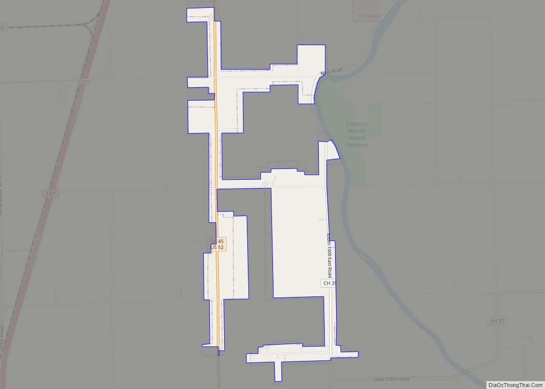
Sammons Point is a village in Otto Township in south-central Kankakee County, Illinois, United States. Initially incorporated as a village on March 21, 2006, it was disincorporated on August 8, 2007, and incorporated again on February 5, 2008. As of the 2010 census it had a population of 279. The village is part of the … Read more

Map of Sandwich city

Map of Sandwich city, Illinois

Sandwich is a city in DeKalb and Kendall counties in the U.S. state of Illinois. Its population was 7,421 at the 2010 census and 7,221 at the 2020 census. Sandwich city overview: Name: Sandwich city LSAD Code: 25 LSAD Description: city (suffix) State: Illinois County: DeKalb County, Kendall County Elevation: 669 ft (204 m) Total Area: 4.75 sq mi … Read more

Map of Sandoval village

Map of Sandoval village, Illinois

Sandoval /sænˈdoʊvəl/ is a village in Marion County, Illinois, United States. The population was 1,157 at the 2020 census. Sandoval village overview: Name: Sandoval village LSAD Code: 47 LSAD Description: village (suffix) State: Illinois County: Marion County Elevation: 505 ft (154 m) Total Area: 1.00 sq mi (2.58 km²) Land Area: 1.00 sq mi (2.58 km²) Water Area: 0.00 sq mi (0.00 km²) Total Population: 1,157 … Read more

Map of Sauk Village village

Map of Sauk Village village

Sauk Village (locally known as “The Village”) is a village in Cook County, Illinois, United States, with a small portion in Will County. The population was 9,921 at the 2020 census. Sauk Village village overview: Name: Sauk Village village LSAD Code: 47 LSAD Description: village (suffix) State: Illinois County: Cook County, Will County Founded: 1842 … Read more

Map of Sauget village

Map of Sauget village

Sauget (/sɔːˈʒeɪ/ saw-ZHAY) is a village in St. Clair County, Illinois, United States. It is part of Greater St. Louis. The population was 141 at the 2020 census, down from 159 in 2010. Sauget village overview: Name: Sauget village LSAD Code: 47 LSAD Description: village (suffix) State: Illinois County: St. Clair County Elevation: 410 ft (120 m) … Read more

Map of Savanna city

Map of Savanna city, Illinois

Savanna is a city in Carroll County, Illinois, United States. The population was 2,783 at the 2020 census, down from 2,945 at the 2010 census. Savanna is located along the Mississippi River at the mouth of the Plum River. Going from north to south, the second automobile bridge between Iowa and Illinois is located just … Read more

Map of Saunemin village

Map of Saunemin village

Saunemin is a village in Livingston County, Illinois, United States. The population was 420 at the 2010 census. It was named after a Kickapoo chief. Saunemin village overview: Name: Saunemin village LSAD Code: 47 LSAD Description: village (suffix) State: Illinois County: Livingston County Elevation: 689 ft (210 m) Total Area: 0.23 sq mi (0.60 km²) Land Area: 0.23 sq mi (0.60 km²) Water … Read more

Map of Sawyerville village

Map of Sawyerville village

Sawyerville is a village in Macoupin County, Illinois, United States. As of the 2020 census the population was 268. Sawyerville village overview: Name: Sawyerville village LSAD Code: 47 LSAD Description: village (suffix) State: Illinois County: Macoupin County Total Area: 1.00 sq mi (2.59 km²) Land Area: 0.99 sq mi (2.56 km²) Water Area: 0.01 sq mi (0.04 km²) Total Population: 268 Population Density: 271.26/sq mi … Read more

Map of Savoy village

Map of Savoy village, Illinois

Savoy is a village in Champaign County, Illinois, United States. The population was 8,857 at the 2020 census. Savoy village overview: Name: Savoy village LSAD Code: 47 LSAD Description: village (suffix) State: Illinois County: Champaign County Total Area: 3.30 sq mi (8.56 km²) Land Area: 3.23 sq mi (8.37 km²) Water Area: 0.07 sq mi (0.18 km²) Total Population: 8,857 Population Density: 2,739.56/sq mi (1,057.69/km²) … Read more

Map of Scales Mound village

Map of Scales Mound village

Scales Mound is a village in Jo Daviess County, Illinois, United States. The population was 436 at the 2020 census. Scales Mound village overview: Name: Scales Mound village LSAD Code: 47 LSAD Description: village (suffix) State: Illinois County: Jo Daviess County Elevation: 955 ft (291 m) Total Area: 0.63 sq mi (1.63 km²) Land Area: 0.63 sq mi (1.63 km²) Water Area: 0.00 sq mi … Read more

Map of Saybrook village

Map of Saybrook village

Saybrook is a village in McLean County, Illinois, United States. The population was 654 at the 2020 census. It is part of the Bloomington–Normal Metropolitan Statistical Area. Known by locals as the “City of Shade and Water”, it is believed to be named in honor of Old Saybrook, Connecticut. Saybrook village overview: Name: Saybrook village … Read more

Map of Schiller Park village

Map of Schiller Park village

Schiller Park is a village in Cook County, Illinois, United States. The population was 11,709 at the 2020 census. Schiller Park village overview: Name: Schiller Park village LSAD Code: 47 LSAD Description: village (suffix) State: Illinois County: Cook County Total Area: 2.77 sq mi (7.17 km²) Land Area: 2.77 sq mi (7.17 km²) Water Area: 0.00 sq mi (0.00 km²) Total Population: 11,709 Population … Read more