Map of Schaumburg village

Map of Schaumburg village

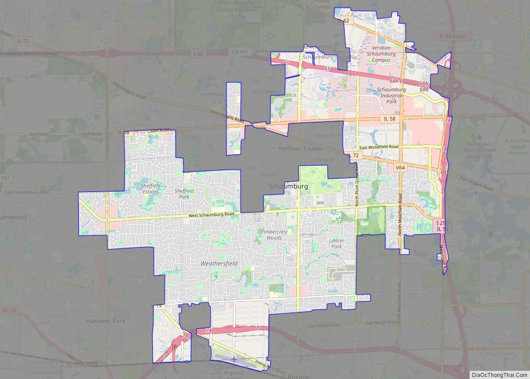
Schaumburg (/ˈʃɔːmbɜːrɡ/ SHAWM-burg) is a village located mostly in Cook County and partly in DuPage County in northeastern Illinois, United States. Per the 2020 Census, the population was 78,723. Schaumburg is around 28 miles (45 km) northwest of the Chicago Loop and 10 miles (16 km) northwest of O’Hare International Airport. It is part of the Golden … Read more

Map of Sciota village

Map of Sciota village

Sciota /saɪˈoʊdə/ is a village in McDonough County, Illinois, United States. The population was 38 at the 2020 census, down from 61 in 2010. Sciota village overview: Name: Sciota village LSAD Code: 47 LSAD Description: village (suffix) State: Illinois County: McDonough County Founded: 1867 Elevation: 758 ft (231 m) Total Area: 0.31 sq mi (0.81 km²) Land Area: 0.31 sq mi (0.81 km²) … Read more

Map of Schram City village

Map of Schram City village

Schram City is a village in Montgomery County, Illinois, United States. The population was 563 at the 2020 census. Schram City village overview: Name: Schram City village LSAD Code: 47 LSAD Description: village (suffix) State: Illinois County: Montgomery County Elevation: 627 ft (191 m) Total Area: 0.67 sq mi (1.74 km²) Land Area: 0.67 sq mi (1.74 km²) Water Area: 0.00 sq mi (0.00 km²) Total … Read more

Map of Scottville village

Map of Scottville village, Illinois

Scottville is a village in Macoupin County, Illinois, United States. The population was 93 at the 2020 census. Scottville village overview: Name: Scottville village LSAD Code: 47 LSAD Description: village (suffix) State: Illinois County: Macoupin County Elevation: 651 ft (198 m) Total Area: 1.00 sq mi (2.58 km²) Land Area: 1.00 sq mi (2.58 km²) Water Area: 0.00 sq mi (0.00 km²) Total Population: 93 Population … Read more

Map of Scott AFB CDP

Map of Scott AFB CDP

Scott AFB CDP overview: Name: Scott AFB CDP LSAD Code: 57 LSAD Description: CDP (suffix) State: Illinois County: St. Clair County FIPS code: 1768328 Online Interactive Map Scott AFB online map. Source: Basemap layers from Google Map, Open Street Map (OSM), Arcgisonline, Wmflabs. Boundary Data from Database of Global Administrative Areas. Scott AFB location map. … Read more

Map of Seatonville village

Map of Seatonville village

Seatonville is a village in Bureau County, Illinois, United States. The population was 321 at the 2020 census. It is part of the Ottawa Micropolitan Statistical Area. Seatonville village overview: Name: Seatonville village LSAD Code: 47 LSAD Description: village (suffix) State: Illinois County: Bureau County Total Area: 0.511 sq mi (1.32 km²) Land Area: 0.496 sq mi (1.28 km²) Water Area: … Read more

Map of Seaton village

Map of Seaton village

Seaton is a village in Mercer County, Illinois, United States. The population was 214 at the 2020 census. Seaton village overview: Name: Seaton village LSAD Code: 47 LSAD Description: village (suffix) State: Illinois County: Mercer County Elevation: 615 ft (187 m) Total Area: 1.58 sq mi (4.09 km²) Land Area: 1.58 sq mi (4.09 km²) Water Area: 0.00 sq mi (0.00 km²) Total Population: 214 Population … Read more

Map of Seneca village

Map of Seneca village, Illinois

Seneca is a village in LaSalle and Grundy counties in the U.S. state of Illinois. The population was 2,353 at the 2020 census, down from 2,371 at the 2010 census. The LaSalle County portion of Seneca is part of the Ottawa Micropolitan Statistical Area, while the small portion that lies in Grundy County is part … Read more

Map of Secor village

Map of Secor village

Secor is a village in Clayton Township, Woodford County, Illinois, United States. The population was 373 at the 2010 census. It is part of the Peoria, Illinois Metropolitan Statistical Area. Secor is located just off U.S. Route 24 between El Paso and Eureka. Secor village overview: Name: Secor village LSAD Code: 47 LSAD Description: village … Read more

Map of Seymour CDP, Illinois

Map of Seymour CDP, Illinois

Seymour is a census-designated place in Champaign County, Illinois, United States. At the 2020 census it had a population of 317. It is part of Mahomet-Seymour Community Unit School District No. 3. Seymour CDP overview: Name: Seymour CDP LSAD Code: 57 LSAD Description: CDP (suffix) State: Illinois County: Champaign County Elevation: 712 ft (217 m) Total Area: … Read more

Map of Sesser city

Map of Sesser city

Sesser is a city in Franklin County, Illinois, United States. The population was 1,931 at the 2010 census. The current mayor is C. Jason Ashmore. Sesser city overview: Name: Sesser city LSAD Code: 25 LSAD Description: city (suffix) State: Illinois County: Franklin County Elevation: 482 ft (147 m) Total Area: 1.03 sq mi (2.67 km²) Land Area: 1.03 sq mi (2.67 km²) Water … Read more

Map of Shannon village, Illinois

Map of Shannon village, Illinois

Shannon is a village in Carroll County, Illinois, United States. The population was 801 at the 2020 census, up from 757 at the 2010 census. Shannon village overview: Name: Shannon village LSAD Code: 47 LSAD Description: village (suffix) State: Illinois County: Carroll County Elevation: 915 ft (279 m) Total Area: 0.48 sq mi (1.25 km²) Land Area: 0.48 sq mi (1.25 km²) Water … Read more