Map of Milford city, Iowa

Map of Milford city, Iowa

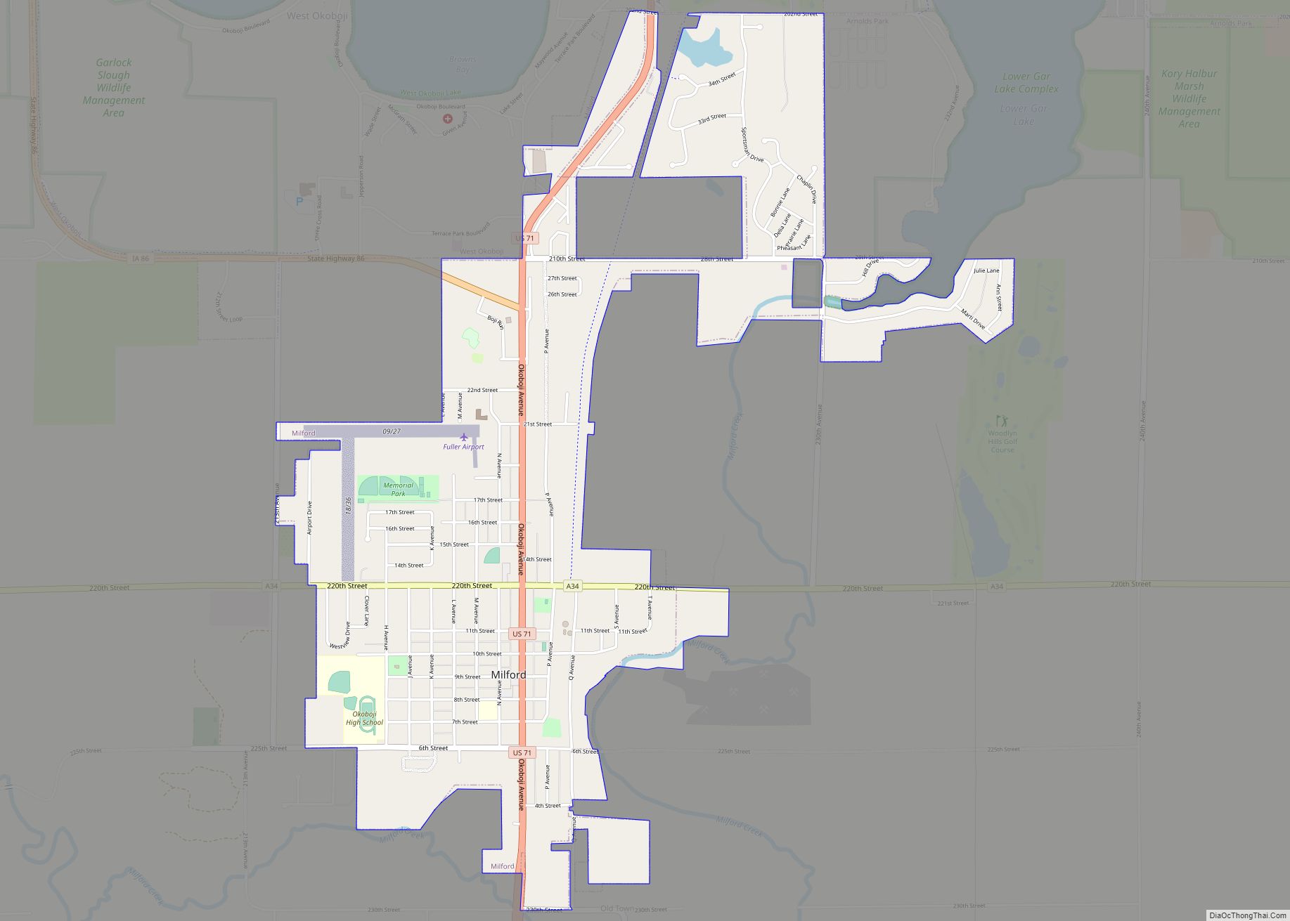
Milford is a city in Dickinson County, Iowa, United States. The population was 3,321 at the time of the 2020 census. The town includes many businesses related to its location in the Iowa Great Lakes region and is often referred to as the southern gateway to the Iowa Great Lakes. Milford city overview: Name: Milford … Read more

Map of Miles city

Map of Miles city, Iowa

Miles is a small city in southeastern Jackson County, Iowa, United States. The population was 408 at the time of the 2020 census. Miles city overview: Name: Miles city LSAD Code: 25 LSAD Description: city (suffix) State: Iowa County: Jackson County Incorporated: May 4, 1893 Elevation: 801 ft (244 m) Total Area: 1.26 sq mi (3.27 km²) Land Area: 1.26 sq mi … Read more

Map of Milo city

Map of Milo city, Iowa

Milo is a city in Warren County, Iowa, United States. The population was 778 at the time of the 2020 census. It is part of the Des Moines–West Des Moines Metropolitan Statistical Area. Milo city overview: Name: Milo city LSAD Code: 25 LSAD Description: city (suffix) State: Iowa County: Warren County Elevation: 971 ft (296 m) Total … Read more

Map of Millerton city

Map of Millerton city, Iowa

Millerton is a city in Wayne County, Iowa, United States. The population was 36 at the time of the 2020 census. Millerton city overview: Name: Millerton city LSAD Code: 25 LSAD Description: city (suffix) State: Iowa County: Wayne County Elevation: 1,073 ft (327 m) Total Area: 0.29 sq mi (0.76 km²) Land Area: 0.29 sq mi (0.76 km²) Water Area: 0.00 sq mi (0.00 km²) Total … Read more

Map of Millersburg city

Map of Millersburg city, Iowa

Millersburg is a city in Iowa County, Iowa, United States. The population was 135 at the time of the 2020 census. Millersburg city overview: Name: Millersburg city LSAD Code: 25 LSAD Description: city (suffix) State: Iowa County: Iowa County Elevation: 873 ft (266 m) Total Area: 0.12 sq mi (0.31 km²) Land Area: 0.12 sq mi (0.31 km²) Water Area: 0.00 sq mi (0.00 km²) Total … Read more

Map of Minden city

Map of Minden city, Iowa

Minden is a city in Pottawattamie County, Iowa, United States. The population was 600 at the time of the 2020 census. It has possessed a post office since 1875. Minden city overview: Name: Minden city LSAD Code: 25 LSAD Description: city (suffix) State: Iowa County: Pottawattamie County Elevation: 1,211 ft (369 m) Total Area: 0.57 sq mi (1.48 km²) Land … Read more

Map of Minburn city

Map of Minburn city

Minburn is a city in Dallas County, Iowa, United States. The population was 325 at the time of the 2020 census. It is part of the Des Moines–West Des Moines Metropolitan Statistical Area. Minburn city overview: Name: Minburn city LSAD Code: 25 LSAD Description: city (suffix) State: Iowa County: Dallas County Elevation: 1,047 ft (319 m) Total … Read more

Map of Milton city, Iowa

Map of Milton city, Iowa

Milton is a city in Van Buren County, Iowa, United States. The population was 380 at the time of the 2020 census. Milton city overview: Name: Milton city LSAD Code: 25 LSAD Description: city (suffix) State: Iowa County: Van Buren County Elevation: 797 ft (243 m) Total Area: 2.69 sq mi (6.97 km²) Land Area: 2.69 sq mi (6.97 km²) Water Area: 0.00 sq mi … Read more

Map of Missouri Valley city

Map of Missouri Valley city

Missouri Valley is a city in Harrison County, Iowa, United States. The population was 2,678 at the time of the 2020 census. Missouri Valley city overview: Name: Missouri Valley city LSAD Code: 25 LSAD Description: city (suffix) State: Iowa County: Harrison County Incorporated: October 30, 1871 Elevation: 1,017 ft (310 m) Total Area: 3.32 sq mi (8.61 km²) Land Area: … Read more

Map of Mingo city

Map of Mingo city

Mingo is a city in Jasper County, Iowa, United States. The population was 302 at the time of the 2020 census. Mingo city overview: Name: Mingo city LSAD Code: 25 LSAD Description: city (suffix) State: Iowa County: Jasper County Elevation: 837 ft (255 m) Total Area: 0.62 sq mi (1.60 km²) Land Area: 0.62 sq mi (1.60 km²) Water Area: 0.00 sq mi (0.00 km²) Total … Read more

Map of Mineola CDP

Map of Mineola CDP, Iowa

Mineola is an unincorporated village and census-designated place in Mills County, Iowa, United States. As of the 2020 census, the population of Mineola was 154. Mineola is in the Glenwood Community School District. Mineola CDP overview: Name: Mineola CDP LSAD Code: 57 LSAD Description: CDP (suffix) State: Iowa County: Mills County Elevation: 1,030 ft (310 m) Total … Read more

Map of Modale city

Map of Modale city

Modale is a city in Harrison County, Iowa, United States. The population was 273 at the time of the 2020 census. Modale city overview: Name: Modale city LSAD Code: 25 LSAD Description: city (suffix) State: Iowa County: Harrison County Elevation: 1,010 ft (308 m) Total Area: 1.04 sq mi (2.70 km²) Land Area: 1.04 sq mi (2.70 km²) Water Area: 0.00 sq mi (0.00 km²) Total … Read more