Map of New Liberty city

Map of New Liberty city

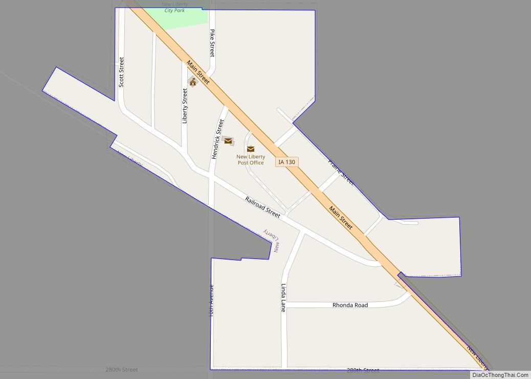
New Liberty is a city in Scott County, Iowa, United States. The population was 138 at the time of the 2020 census. New Liberty city overview: Name: New Liberty city LSAD Code: 25 LSAD Description: city (suffix) State: Iowa County: Scott County Elevation: 797 ft (243 m) Land Area: 0.09 sq mi (0.23 km²) Water Area: 0.00 sq mi (0.00 km²) Population Density: … Read more

Map of New Haven CDP, Iowa

Map of New Haven CDP, Iowa

New Haven is an unincorporated community and census-designated place in Mitchell County, Iowa, United States. As of the 2020 census the population of New Haven was 77. New Haven CDP overview: Name: New Haven CDP LSAD Code: 57 LSAD Description: CDP (suffix) State: Iowa County: Mitchell County Elevation: 1,119 ft (341 m) Total Area: 1.93 sq mi (4.99 km²) Land … Read more

Map of New Sharon city

Map of New Sharon city

New Sharon is a city in Mahaska County, Iowa, United States. The population was 1,262 at the time of the 2020 census. The first building was erected in 1856 by Edward Quaintance. New Sharon city overview: Name: New Sharon city LSAD Code: 25 LSAD Description: city (suffix) State: Iowa County: Mahaska County Elevation: 873 ft (266 m) … Read more

Map of New Providence city

Map of New Providence city, Iowa

New Providence is a small city in Hardin County, Iowa, United States. The population was 236 at the time of the 2020 census. New Providence city overview: Name: New Providence city LSAD Code: 25 LSAD Description: city (suffix) State: Iowa County: Hardin County Elevation: 1,129 ft (344 m) Total Area: 1.00 sq mi (2.59 km²) Land Area: 1.00 sq mi (2.59 km²) Water … Read more

Map of New Market city, Iowa

Map of New Market city, Iowa

New Market is a city in Taylor County, Iowa, United States. The population was 385 at the time of the 2020 census. New Market city overview: Name: New Market city LSAD Code: 25 LSAD Description: city (suffix) State: Iowa County: Taylor County Elevation: 1,234 ft (376 m) Total Area: 0.43 sq mi (1.12 km²) Land Area: 0.43 sq mi (1.12 km²) Water Area: … Read more

Map of Newell city, Iowa

Map of Newell city, Iowa

Newell is a city in Buena Vista County, Iowa, United States. The population was 906 according to the 2020 census. Newell city overview: Name: Newell city LSAD Code: 25 LSAD Description: city (suffix) State: Iowa County: Buena Vista County Elevation: 1,263 ft (385 m) Total Area: 1.26 sq mi (3.27 km²) Land Area: 1.26 sq mi (3.27 km²) Water Area: 0.00 sq mi (0.00 km²) Total … Read more

Map of New Virginia city

Map of New Virginia city

New Virginia is a city in Warren County, Iowa, United States. The population was 498 at the time of the 2020 census. It is part of the Des Moines–West Des Moines Metropolitan Statistical Area. New Virginia city overview: Name: New Virginia city LSAD Code: 25 LSAD Description: city (suffix) State: Iowa County: Warren County Elevation: … Read more

Map of New Vienna city

Map of New Vienna city, Iowa

New Vienna is a city in Dubuque County, Iowa, United States. It is part of the Dubuque, Iowa Metropolitan Statistical Area. The population was 382 at the time of the 2020 census, down from 400 in 2000. New Vienna is the home to the Saint Boniface Catholic Church. The city promotes itself with the slogan … Read more

Map of Nichols city

Map of Nichols city, Iowa

Nichols is a city in Muscatine County, Iowa, United States. The population was 340 at the time of the 2020 census. It is part of the Muscatine Micropolitan Statistical Area. Nichols city overview: Name: Nichols city LSAD Code: 25 LSAD Description: city (suffix) State: Iowa County: Muscatine County Elevation: 633 ft (193 m) Total Area: 0.23 sq mi (0.59 km²) … Read more

Map of Newton city, Iowa

Map of Newton city, Iowa

Newton is the county seat of, and most populous city in, Jasper County, Iowa, United States. Located 30 miles (48 km) east of Des Moines, Newton is in Central Iowa. As of the 2020 Census, the city population was 15,760. It is the home of Iowa Speedway and Maytag Dairy Farms. Newton city overview: Name: Newton … Read more

Map of Newhall city

Map of Newhall city

Newhall is a city in Benton County, Iowa, United States. The population was 876 at the time of the 2020 census. It is part of the Cedar Rapids Metropolitan Statistical Area. Newhall city overview: Name: Newhall city LSAD Code: 25 LSAD Description: city (suffix) State: Iowa County: Benton County Elevation: 876 ft (267 m) Total Area: 0.30 sq mi … Read more

Map of North Buena Vista city

Map of North Buena Vista city

North Buena Vista is a city in Clayton County, Iowa, United States. The population was 109 at the time of the 2020 census, down from 124 in 2000. North Buena Vista city overview: Name: North Buena Vista city LSAD Code: 25 LSAD Description: city (suffix) State: Iowa County: Clayton County Elevation: 650 ft (198 m) Total Area: … Read more