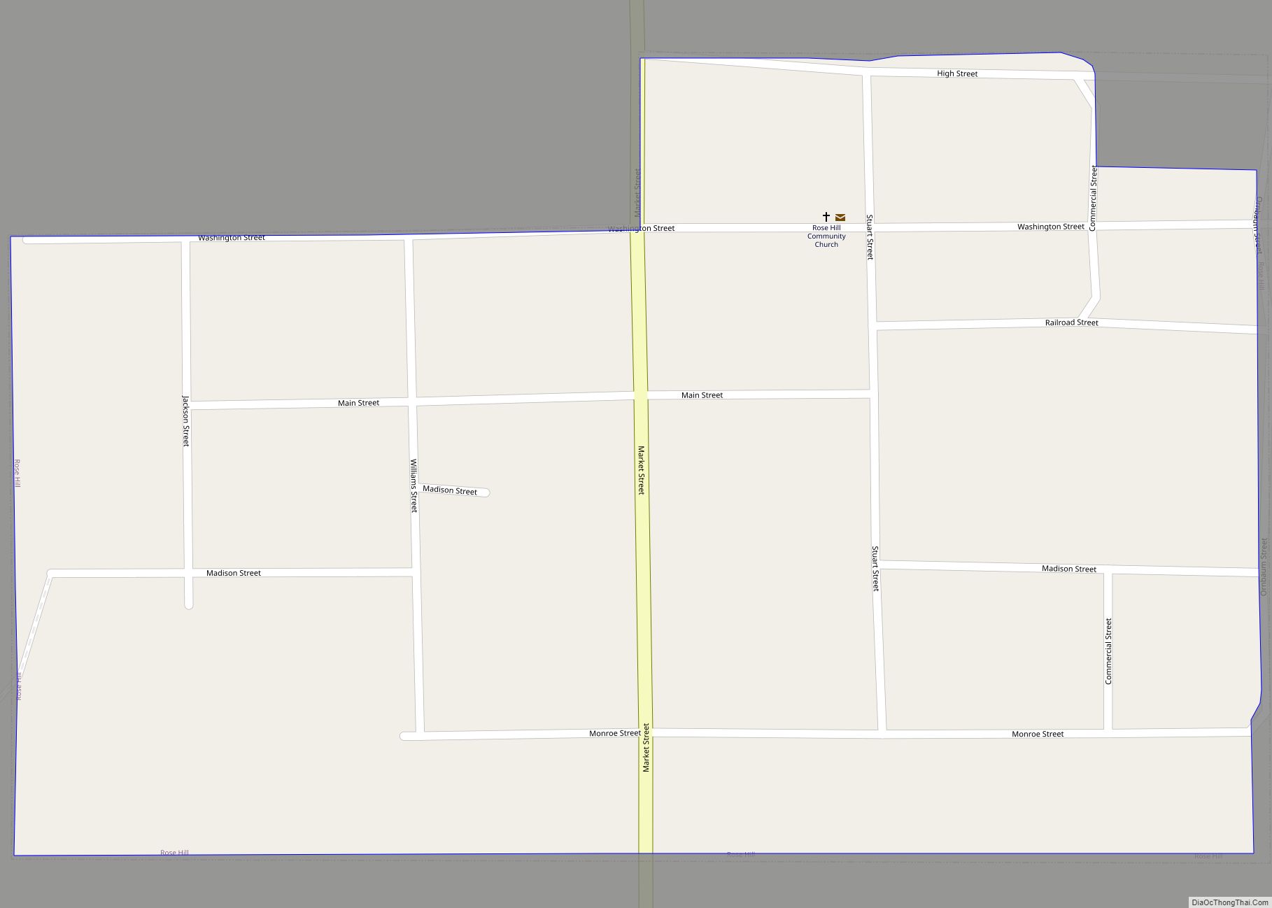
Map of Rome city, Iowa

Map of Rome city, Iowa

Rome is a village in Henry County, Iowa, United States. The population was 114 at the time of the 2020 census. Rome city overview: Name: Rome city LSAD Code: 25 LSAD Description: city (suffix) State: Iowa County: Henry County Elevation: 597 ft (182 m) Total Area: 0.13 sq mi (0.32 km²) Land Area: 0.12 sq mi (0.32 km²) Water Area: 0.00 sq mi (0.00 km²) Total … Read more

Map of Rolfe city

Map of Rolfe city

Rolfe is a city in Pocahontas County, Iowa, United States. The population was 509 at the time of the 2020 census. This city was named after the Englishman John Rolfe, who married Pocahontas in Jamestown, Virginia. Rolfe city overview: Name: Rolfe city LSAD Code: 25 LSAD Description: city (suffix) State: Iowa County: Pocahontas County Elevation: … Read more

Map of Rowan city

Map of Rowan city

Rowan is a city in Wright County, Iowa, United States. The population was 123 at the time of the 2020 census. Rowan city overview: Name: Rowan city LSAD Code: 25 LSAD Description: city (suffix) State: Iowa County: Wright County Elevation: 1,211 ft (369 m) Total Area: 0.52 sq mi (1.35 km²) Land Area: 0.52 sq mi (1.35 km²) Water Area: 0.00 sq mi (0.00 km²) Total … Read more

Map of Rossie city

Map of Rossie city

Rossie is a city in Clay County, Iowa, United States. The population was 49 in the 2020 census, a decrease from 58 in 2000. Rossie city overview: Name: Rossie city LSAD Code: 25 LSAD Description: city (suffix) State: Iowa County: Clay County Elevation: 1,407 ft (429 m) Total Area: 0.14 sq mi (0.37 km²) Land Area: 0.14 sq mi (0.37 km²) Water Area: … Read more

Map of Roseville CDP, Iowa

Map of Roseville CDP, Iowa

Roseville is a census-designated place mainly located in Ulster Township and a small portion in the northern part of Union Township in Floyd County in the state of Iowa. As of the 2010 census the population was 49. Its location is approximately 6 miles (10 km) northeast of the city of Marble Rock or 11 miles … Read more

Map of Rudd city

Map of Rudd city

Rudd is a city in Floyd County, Iowa, United States. The population was 358 at the time of the 2020 census, a decline of 16.9% from 431 in 2000. Rudd city overview: Name: Rudd city LSAD Code: 25 LSAD Description: city (suffix) State: Iowa County: Floyd County Elevation: 1,109 ft (338 m) Total Area: 1.09 sq mi (2.82 km²) Land … Read more

Map of Royal city

Map of Royal city, Iowa

Royal is a city in Clay County, Iowa, United States. The population was 379 in the 2020 census, a decline from 479 in 2000. Royal city overview: Name: Royal city LSAD Code: 25 LSAD Description: city (suffix) State: Iowa County: Clay County Elevation: 1,411 ft (430 m) Total Area: 0.29 sq mi (0.76 km²) Land Area: 0.29 sq mi (0.76 km²) Water Area: … Read more

Map of Rowley city

Map of Rowley city, Iowa

Rowley is a city in Buchanan County, Iowa, United States. The population was 270 at the time of the 2020 census. Rowley city overview: Name: Rowley city LSAD Code: 25 LSAD Description: city (suffix) State: Iowa County: Buchanan County Elevation: 981 ft (299 m) Total Area: 0.39 sq mi (1.01 km²) Land Area: 0.39 sq mi (1.01 km²) Water Area: 0.00 sq mi (0.00 km²) Total … Read more

Map of Ruthven city

Map of Ruthven city

Ruthven is a city in Palo Alto County, Iowa, United States. The population was 725 at the time of the 2020 census. Ruthven city overview: Name: Ruthven city LSAD Code: 25 LSAD Description: city (suffix) State: Iowa County: Palo Alto County Elevation: 1,440 ft (439 m) Total Area: 0.41 sq mi (1.06 km²) Land Area: 0.41 sq mi (1.06 km²) Water Area: 0.00 sq mi … Read more

Map of Russell city, Iowa

Map of Russell city, Iowa

Russell is a city in Lucas County, Iowa, United States. The population was 472 in the 2020 census, a decline from the 559 population in 2000. Russell city overview: Name: Russell city LSAD Code: 25 LSAD Description: city (suffix) State: Iowa County: Lucas County Incorporated: April 25, 1887 Elevation: 1,030 ft (314 m) Total Area: 1.02 sq mi (2.66 km²) … Read more

Map of Runnells city

Map of Runnells city

Runnells is a city in the southeastern corner of Polk County, Iowa, United States. The population was 457 at the time of the 2020 census. It is part of the Des Moines–West Des Moines Metropolitan Statistical Area. Runnells has its own Post Office, located at 112 Brown Street. Runnells city overview: Name: Runnells city LSAD … Read more

Map of Sabula city

Map of Sabula city

Sabula is a city in Jackson County, Iowa, United States. The population was 506 at the 2020 census. Sabula is the site of Iowa’s only island city. The island has a beach and a campground, as well as a harbor with boat docks and storage sheds to store boats during the winter. Because of its … Read more