Map of Haddam city

Map of Haddam city

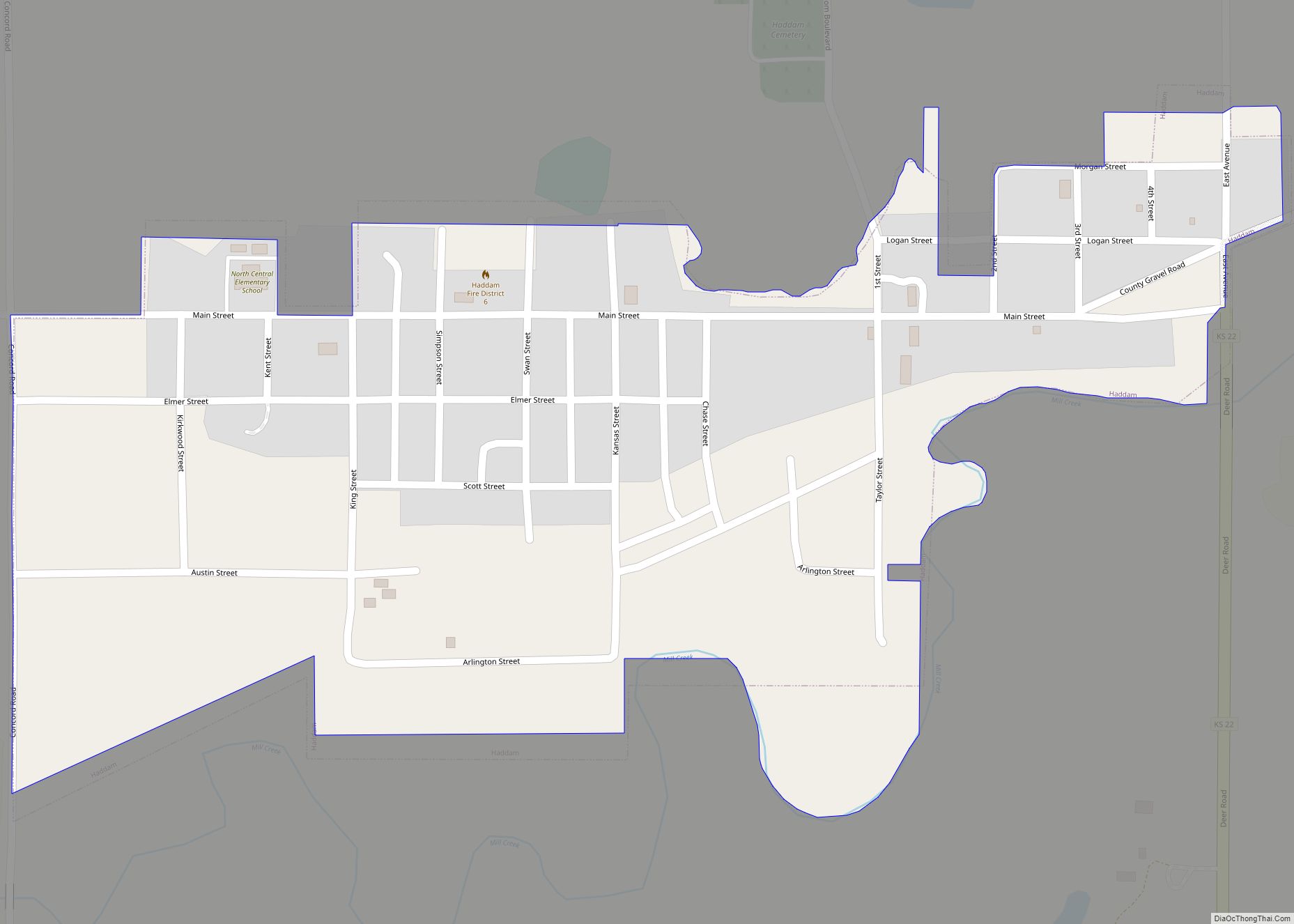
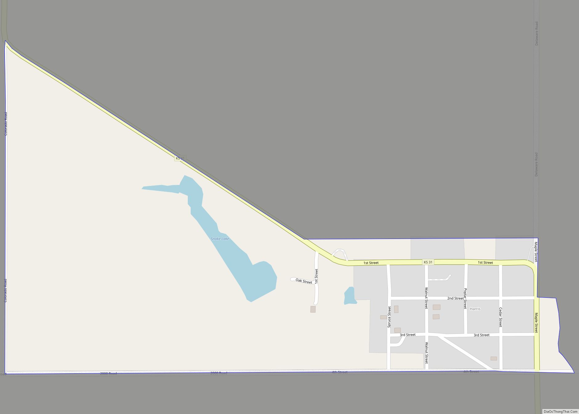
Haddam is a city in Washington County, Kansas, United States. It is named after Haddam, Connecticut. As of the 2020 census, the population of the city was 110. Haddam city overview: Name: Haddam city LSAD Code: 25 LSAD Description: city (suffix) State: Kansas County: Washington County Founded: 1869 Incorporated: 1886 Elevation: 1,385 ft (422 m) Total Area: … Read more

Map of Hanston city

Map of Hanston city

Hanston is a city in Hodgeman County, Kansas, United States. As of the 2020 census, the population of the city was 259. Hanston city overview: Name: Hanston city LSAD Code: 25 LSAD Description: city (suffix) State: Kansas County: Hodgeman County Founded: 1878 Incorporated: 1929 Elevation: 2,159 ft (658 m) Total Area: 0.27 sq mi (0.70 km²) Land Area: 0.27 sq mi (0.70 km²) … Read more

Map of Hanover city, Kansas

Map of Hanover city, Kansas

Hanover is a city in Washington County, Kansas, United States. As of the 2020 census, the population of the city was 690. The city is primarily agricultural, and the surrounding countryside is filled with small family farms. Named after Hanover, Germany, the town is a traditional German community with strong German cultural influences. The local … Read more

Map of Hamlin city

Map of Hamlin city, Kansas

Hamlin is a city in Brown County, Kansas, United States. As of the 2020 census, the population of the city was 25. Hamlin city overview: Name: Hamlin city LSAD Code: 25 LSAD Description: city (suffix) State: Kansas County: Brown County Founded: 1870 Incorporated: 1889 Elevation: 1,001 ft (305 m) Total Area: 0.09 sq mi (0.23 km²) Land Area: 0.09 sq mi (0.23 km²) … Read more

Map of Harris CDP, Kansas

Map of Harris CDP, Kansas

Harris is an unincorporated community in Anderson County, Kansas, United States. As of the 2020 census, the population of the community and nearby areas was 47. Harris CDP overview: Name: Harris CDP LSAD Code: 57 LSAD Description: CDP (suffix) State: Kansas County: Anderson County Founded: 1886 Elevation: 1,001 ft (305 m) Total Area: 0.36 sq mi (0.93 km²) Land Area: … Read more

Map of Harper city, Kansas

Map of Harper city, Kansas

Harper is a city in Harper County, Kansas, United States. As of the 2020 census, the population of the city was 1,313. Harper city overview: Name: Harper city LSAD Code: 25 LSAD Description: city (suffix) State: Kansas County: Harper County Founded: 1877 Incorporated: 1880 Elevation: 1,421 ft (433 m) Total Area: 1.62 sq mi (4.20 km²) Land Area: 1.62 sq mi (4.20 km²) … Read more

Map of Hardtner city

Map of Hardtner city

Hardtner is a city in Barber County, Kansas, United States. As of the 2020 census, the population of the city was 167. It is located 1 mile north of the Kansas / Oklahoma state border. Hardtner city overview: Name: Hardtner city LSAD Code: 25 LSAD Description: city (suffix) State: Kansas County: Barber County Founded: 1887 … Read more

Map of Havana city, Kansas

Map of Havana city, Kansas

Havana is a city in Montgomery County, Kansas, United States. As of the 2020 census, the population of the city was 84. Havana city overview: Name: Havana city LSAD Code: 25 LSAD Description: city (suffix) State: Kansas County: Montgomery County Founded: 1870 Incorporated: 1909 Elevation: 761 ft (232 m) Total Area: 0.16 sq mi (0.41 km²) Land Area: 0.16 sq mi (0.41 km²) … Read more

Map of Harveyville city

Map of Harveyville city

Harveyville is a city in Wabaunsee County, Kansas, United States. As of the 2020 census, the population of the city was 178. It is located 8.5 miles (13.7 km) northwest of the city of Burlingame. Harveyville city overview: Name: Harveyville city LSAD Code: 25 LSAD Description: city (suffix) State: Kansas County: Wabaunsee County Founded: 1880 Incorporated: … Read more

Map of Hartford city, Kansas

Map of Hartford city, Kansas

Hartford is a city in Lyon County, Kansas, United States. As of the 2020 census, the population of the city was 355. Hartford city overview: Name: Hartford city LSAD Code: 25 LSAD Description: city (suffix) State: Kansas County: Lyon County Incorporated: 1929 Elevation: 1,083 ft (330 m) Total Area: 0.40 sq mi (1.03 km²) Land Area: 0.40 sq mi (1.03 km²) Water Area: … Read more

Map of Haviland city

Map of Haviland city, Kansas

Haviland is a city in Kiowa County, Kansas, United States. As of the 2020 census, the population of the city was 678. It is home of Barclay College and known for meteorite finds connected to the Haviland Crater and for an annual meteorite festival held in July. Haviland city overview: Name: Haviland city LSAD Code: … Read more

Map of Havensville city

Map of Havensville city

Havensville is a city in Pottawatomie County, Kansas, United States. As of the 2020 census, the population of the city was 119. Havensville city overview: Name: Havensville city LSAD Code: 25 LSAD Description: city (suffix) State: Kansas County: Pottawatomie County Founded: 1878 Incorporated: 1892 Elevation: 1,201 ft (366 m) Total Area: 0.14 sq mi (0.38 km²) Land Area: 0.14 sq mi (0.38 km²) … Read more