Map of South Hutchinson city

Map of South Hutchinson city

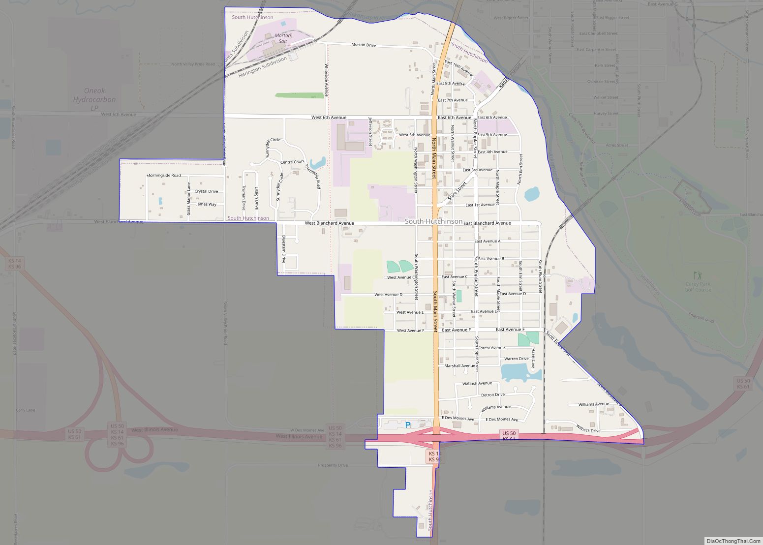
South Hutchinson is a city in Reno County, Kansas, United States. As of the 2020 census, the population of the city was 2,521. It is a south suburb of Hutchinson. South Hutchinson city overview: Name: South Hutchinson city LSAD Code: 25 LSAD Description: city (suffix) State: Kansas County: Reno County Founded: 1887 Incorporated: 1887 Elevation: … Read more

Map of St. Francis city, Kansas

Map of St. Francis city, Kansas

St. Francis city overview: Name: St. Francis city LSAD Code: 25 LSAD Description: city (suffix) State: Kansas County: Cheyenne County FIPS code: 2062175 Online Interactive Map St. Francis online map. Source: Basemap layers from Google Map, Open Street Map (OSM), Arcgisonline, Wmflabs. Boundary Data from Database of Global Administrative Areas. St. Francis location map. Where … Read more

Map of Spring Hill city, Kansas

Map of Spring Hill city, Kansas

Spring Hill is a city in Johnson and Miami counties in the U.S. state of Kansas, and part of the Kansas City Metropolitan Area. As of the 2020 census, the population of the city was 7,952. Spring Hill city overview: Name: Spring Hill city LSAD Code: 25 LSAD Description: city (suffix) State: Kansas County: Johnson … Read more

Map of Spivey city

Map of Spivey city

Spivey is a city in Kingman County, Kansas, United States. As of the 2020 census, the population of the city was 61. Spivey city overview: Name: Spivey city LSAD Code: 25 LSAD Description: city (suffix) State: Kansas County: Kingman County Founded: 1880s Incorporated: 1887 Elevation: 1,509 ft (460 m) Total Area: 0.52 sq mi (1.35 km²) Land Area: 0.52 sq mi (1.35 km²) … Read more

Map of St. Marys city, Kansas

Map of St. Marys city, Kansas

St. Marys city overview: Name: St. Marys city LSAD Code: 25 LSAD Description: city (suffix) State: Kansas County: Pottawatomie County, Wabaunsee County FIPS code: 2062400 Online Interactive Map St. Marys online map. Source: Basemap layers from Google Map, Open Street Map (OSM), Arcgisonline, Wmflabs. Boundary Data from Database of Global Administrative Areas. St. Marys location … Read more

Map of St. John city, Kansas

Map of St. John city, Kansas

St. John city overview: Name: St. John city LSAD Code: 25 LSAD Description: city (suffix) State: Kansas County: Stafford County FIPS code: 2062275 Online Interactive Map St. John online map. Source: Basemap layers from Google Map, Open Street Map (OSM), Arcgisonline, Wmflabs. Boundary Data from Database of Global Administrative Areas. St. John location map. Where … Read more

Map of St. George city, Kansas

Map of St. George city, Kansas

St. George city overview: Name: St. George city LSAD Code: 25 LSAD Description: city (suffix) State: Kansas County: Pottawatomie County FIPS code: 2062200 Online Interactive Map St. George online map. Source: Basemap layers from Google Map, Open Street Map (OSM), Arcgisonline, Wmflabs. Boundary Data from Database of Global Administrative Areas. St. George location map. Where … Read more

Map of Stark city

Map of Stark city

Stark is a city in Neosho County, Kansas, United States. As of the 2020 census, the population of the city was 69. Stark city overview: Name: Stark city LSAD Code: 25 LSAD Description: city (suffix) State: Kansas County: Neosho County Founded: 1888 Incorporated: 1910 Elevation: 1,063 ft (324 m) Total Area: 0.16 sq mi (0.43 km²) Land Area: 0.16 sq mi (0.43 km²) … Read more

Map of Stafford city

Map of Stafford city, Kansas

Stafford is a city in Stafford County, Kansas, United States. As of the 2020 census, the population of the city was 959. Stafford city overview: Name: Stafford city LSAD Code: 25 LSAD Description: city (suffix) State: Kansas County: Stafford County Founded: 1878 Incorporated: 1885 Elevation: 1,857 ft (566 m) Total Area: 0.92 sq mi (2.37 km²) Land Area: 0.92 sq mi (2.37 km²) … Read more

Map of St. Paul city, Kansas

Map of St. Paul city, Kansas

St. Paul city overview: Name: St. Paul city LSAD Code: 25 LSAD Description: city (suffix) State: Kansas County: Neosho County FIPS code: 2062500 Online Interactive Map St. Paul online map. Source: Basemap layers from Google Map, Open Street Map (OSM), Arcgisonline, Wmflabs. Boundary Data from Database of Global Administrative Areas. St. Paul location map. Where … Read more

Map of Sterling city, Kansas

Map of Sterling city, Kansas

Sterling is a city in Rice County, Kansas, United States. As of the 2020 census, the population of the city was 2,248. Sterling is home to Sterling College. Sterling city overview: Name: Sterling city LSAD Code: 25 LSAD Description: city (suffix) State: Kansas County: Rice County Founded: 1872 (Peace) Incorporated: 1876 Elevation: 1,641 ft (500 m) Total … Read more

Map of Strong City city

Map of Strong City, Kansas

Strong City is a city in Chase County, Kansas, United States. Originally known as Cottonwood Station, in 1881 it was renamed Strong City after William Barstow Strong, then vice-president and general manager, and later president of the Atchison, Topeka and Santa Fe Railway. As of the 2020 census, the population of the city was 386. … Read more