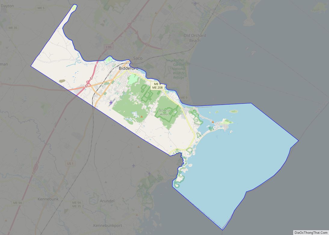
Map of Berwick CDP, Maine

Map of Berwick CDP, Maine

Berwick is a census-designated place (CDP) in the town of Berwick in York County, Maine, United States. The population was 2,187 at the 2010 census, out of a total of 7,246 in the entire town. It is part of the Portland–South Portland–Biddeford, Maine Metropolitan Statistical Area. Berwick CDP overview: Name: Berwick CDP LSAD Code: 57 … Read more

Map of Belfast city

Map of Belfast city, Maine

Belfast is a city in Waldo County, Maine, in the United States. As of the 2020 census, the city population was 6,938. Located at the mouth of the Passagassawakeag River estuary on Belfast Bay and Penobscot Bay. Belfast is the county seat of Waldo County. Its seaport has a wealth of antique architecture in several … Read more

Map of Blue Hill CDP

Map of Blue Hill CDP, Maine

Blue Hill is a census-designated place (CDP) in the town of Blue Hill in Hancock County, Maine, United States. The CDP population was 943 as per the 2010 census, out of a population of 2,686 in the town of Blue Hill as a whole. Blue Hill CDP overview: Name: Blue Hill CDP LSAD Code: 57 … Read more

Map of Blaine CDP, Maine

Map of Blaine CDP, Maine

Blaine is a census-designated place (CDP) comprising the main village within the town of Blaine in Aroostook County, Maine, United States. The population of the CDP was 301 at the 2010 census, out of a population of 726 for the entire town. Prior to 2010, the village was part of the Mars Hill-Blaine CDP. Blaine … Read more

Map of Bingham CDP, Maine

Map of Bingham CDP, Maine

Bingham is a census-designated place (CDP) in the town of Bingham in Somerset County, Maine, United States. The population was 856 at the 2000 census. Bingham CDP overview: Name: Bingham CDP LSAD Code: 57 LSAD Description: CDP (suffix) State: Maine County: Somerset County Elevation: 364 ft (111 m) Total Area: 2.26 sq mi (5.85 km²) Land Area: 2.26 sq mi (5.85 km²) Water … Read more

Map of Brewer city

Map of Brewer city, Maine

Brewer is a city in Penobscot County, Maine, United States. It is part of the Bangor, Maine Metropolitan Statistical Area. The city is named after its first settler, Colonel John Brewer. The population was 9,672 at the 2020 census. Brewer is the sister city of Bangor. The two are at the head of navigation on … Read more

Map of Bowdoinham CDP

Map of Bowdoinham CDP

Bowdoinham is a town in Sagadahoc County, Maine, United States. The population was 3,047 at the 2020 census. It is part of the Portland–South Portland–Biddeford, Maine metropolitan statistical area. The town is located on the west side of Merrymeeting Bay. Bowdoinham CDP overview: Name: Bowdoinham CDP LSAD Code: 57 LSAD Description: CDP (suffix) State: Maine … Read more

Map of Boothbay Harbor CDP

Map of Boothbay Harbor CDP

Boothbay Harbor is a census-designated place (CDP) comprising the densely populated center of the town of Boothbay Harbor in Lincoln County, Maine, United States. The population was 1,086 at the 2010 census, down from 1,237 at the 2000 census. Boothbay Harbor CDP overview: Name: Boothbay Harbor CDP LSAD Code: 57 LSAD Description: CDP (suffix) State: … Read more

Map of Brunswick CDP, Maine

Map of Brunswick CDP, Maine

Brunswick is a census-designated place (CDP) in the town of Brunswick in Cumberland County, Maine, United States. The population was 15,175 at the 2010 census. It is part of the Portland–South Portland–Biddeford, Maine Metropolitan Statistical Area. Brunswick CDP overview: Name: Brunswick CDP LSAD Code: 57 LSAD Description: CDP (suffix) State: Maine County: Cumberland County Elevation: … Read more

Map of Brunswick Station CDP

Map of Brunswick Station CDP

Brunswick Station was a census-designated place (CDP) within the town of Brunswick in Cumberland County, Maine, United States. The population was 578 at the 2010 census. It consists of an area that was part of the former Naval Air Station Brunswick and was part of the Portland–South Portland–Biddeford, Maine Metropolitan Statistical Area. The 2020 census … Read more

Map of Bridgton CDP

Map of Bridgton CDP

Bridgton is a census-designated place (CDP) in the town of Bridgton in Cumberland County, Maine, United States. The population was 2,071 at the 2010 census. It is part of the Portland–South Portland–Biddeford, Maine Metropolitan Statistical Area. Bridgton CDP overview: Name: Bridgton CDP LSAD Code: 57 LSAD Description: CDP (suffix) State: Maine County: Cumberland County Elevation: … Read more

Map of Camden CDP, Maine

Map of Camden CDP, Maine

Camden is a census-designated place (CDP) comprising the main village in the town of Camden in Knox County, Maine, United States. The population was 3,570 at the 2010 census, out of 4,850 in the entire town of Camden. Camden CDP overview: Name: Camden CDP LSAD Code: 57 LSAD Description: CDP (suffix) State: Maine County: Knox … Read more