Map of Fort Kent CDP

Map of Fort Kent CDP

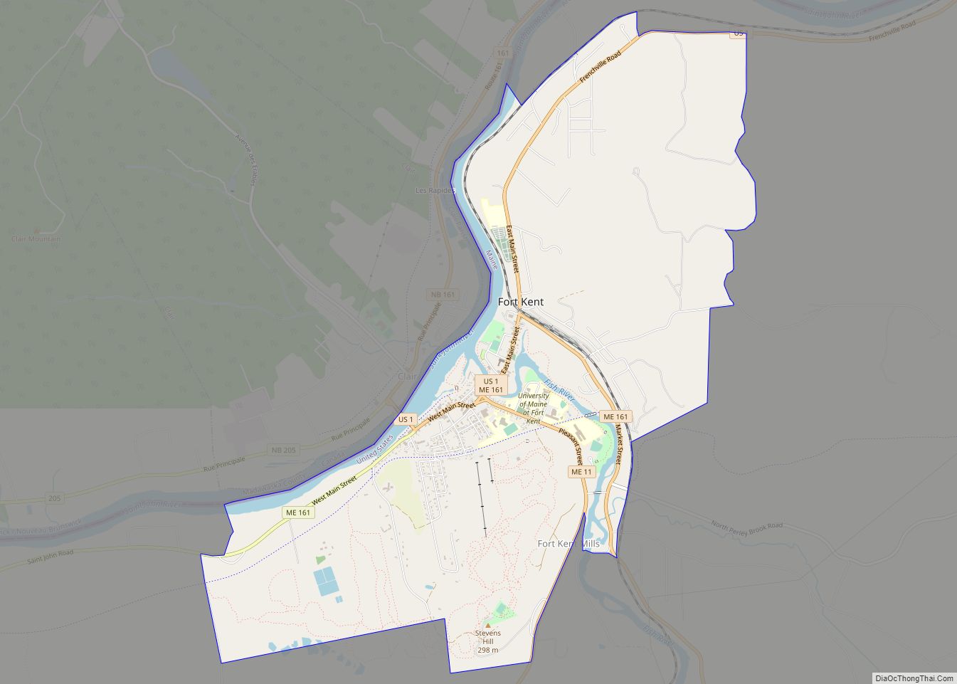
Fort Kent is a census-designated place (CDP) that comprises the main village in the town of Fort Kent in Aroostook County, Maine, United States. In 2010, Fort Kent’s population was 2,488 of 4,097 for the entire town. Fort Kent CDP overview: Name: Fort Kent CDP LSAD Code: 57 LSAD Description: CDP (suffix) State: Maine County: … Read more

Map of Fort Fairfield CDP

Map of Fort Fairfield CDP

Fort Fairfield is a census-designated place (CDP) comprising the main village within the town of Fort Fairfield in Aroostook County, Maine, United States. The population of the CDP was 1,825 at the 2010 census, out of a population of 3,496 for the entire town. Fort Fairfield is named for John Fairfield, 13th and 16th governor … Read more

Map of Gorham CDP, Maine

Map of Gorham CDP, Maine

Gorham is a census-designated place (CDP) in the town of Gorham, in Cumberland County, Maine, United States. The population was 6,882 at the 2010 census. It is part of the Portland–South Portland–Biddeford, Maine Metropolitan Statistical Area. Gorham CDP overview: Name: Gorham CDP LSAD Code: 57 LSAD Description: CDP (suffix) State: Maine County: Cumberland County Elevation: … Read more

Map of Gardiner city

Map of Gardiner city, Maine

Gardiner is a city in Kennebec County, Maine, United States. The population was 5,961 at the 2020 census. Popular with tourists, Gardiner is noted for its culture and old architecture. Gardiner is a nationally accredited Main Street America community. It is included in the Augusta, Maine micropolitan New England City and Town Area. Gardiner city … Read more

Map of Fryeburg CDP

Map of Fryeburg CDP

Fryeburg is a census-designated place (CDP) in the town of Fryeburg in Oxford County, Maine, United States. The population was 1,549 at the 2000 census. Fryeburg CDP overview: Name: Fryeburg CDP LSAD Code: 57 LSAD Description: CDP (suffix) State: Maine County: Oxford County Elevation: 430 ft (131 m) Total Area: 3.01 sq mi (7.80 km²) Land Area: 3.00 sq mi (7.77 km²) Water … Read more

Map of Guilford CDP

Map of Guilford CDP, Maine

Guilford is a census-designated place (CDP) in the town of Guilford in Piscataquis County, Maine, United States. The population was 945 at the 2000 census. Guilford CDP overview: Name: Guilford CDP LSAD Code: 57 LSAD Description: CDP (suffix) State: Maine County: Piscataquis County Elevation: 377 ft (115 m) Total Area: 1.97 sq mi (5.10 km²) Land Area: 1.92 sq mi (4.97 km²) Water … Read more

Map of Greenville CDP, Maine

Map of Greenville CDP, Maine

Greenville is a census-designated place (CDP) in the town of Greenville in Piscataquis County, Maine, United States. The population was 1,319 at the 2000 census. Greenville CDP overview: Name: Greenville CDP LSAD Code: 57 LSAD Description: CDP (suffix) State: Maine County: Piscataquis County Elevation: 1,043 ft (318 m) Total Area: 4.78 sq mi (12.38 km²) Land Area: 4.11 sq mi (10.65 km²) Water … Read more

Map of Gray CDP, Maine

Map of Gray CDP, Maine

Gray is a census-designated place (CDP) within the town of Gray, in Cumberland County, Maine, United States. The population was 884 at the 2010 census., comprising 11.4% of the town’s population of 7,761. Gray (CDP) consists largely of the center of the Town of Gray known as Gray Village. It is part of the Portland–South … Read more

Map of Hartland CDP, Maine

Map of Hartland CDP, Maine

Hartland is a census-designated place (CDP) in the town of Hartland in Somerset County, Maine, United States. The population was 872 at the 2000 census. Hartland CDP overview: Name: Hartland CDP LSAD Code: 57 LSAD Description: CDP (suffix) State: Maine County: Somerset County Elevation: 249 ft (76 m) Total Area: 2.27 sq mi (5.89 km²) Land Area: 2.22 sq mi (5.76 km²) Water … Read more

Map of Hampden CDP

Map of Hampden CDP, Maine

Hampden is a census-designated place (CDP) consisting of the eastern portion of the town of Hampden in Penobscot County, Maine, United States. The population of the CDP was 4,343 at the 2010 census. Hampden CDP overview: Name: Hampden CDP LSAD Code: 57 LSAD Description: CDP (suffix) State: Maine County: Penobscot County Elevation: 108 ft (33 m) Total … Read more

Map of Hallowell city

Map of Hallowell city

Hallowell is a city in Kennebec County, Maine, United States. The population was 2,570 at the 2020 census. Popular with tourists, Hallowell is noted for its culture and old architecture. Hallowell is included in the Augusta, Maine, micropolitan New England City and Town Area. Hallowell city overview: Name: Hallowell city LSAD Code: 25 LSAD Description: … Read more

Map of Kennebunk CDP

Map of Kennebunk CDP

Kennebunk is a census-designated place (CDP) comprising the central village in the town of Kennebunk in York County, Maine, United States. The population was 5,214 at the 2010 census, out of a total town population of 10,798. It is part of the Portland–South Portland–Biddeford, Maine Metropolitan Statistical Area. Kennebunk CDP overview: Name: Kennebunk CDP LSAD … Read more