Map of Galena town, Maryland

Map of Galena town, Maryland

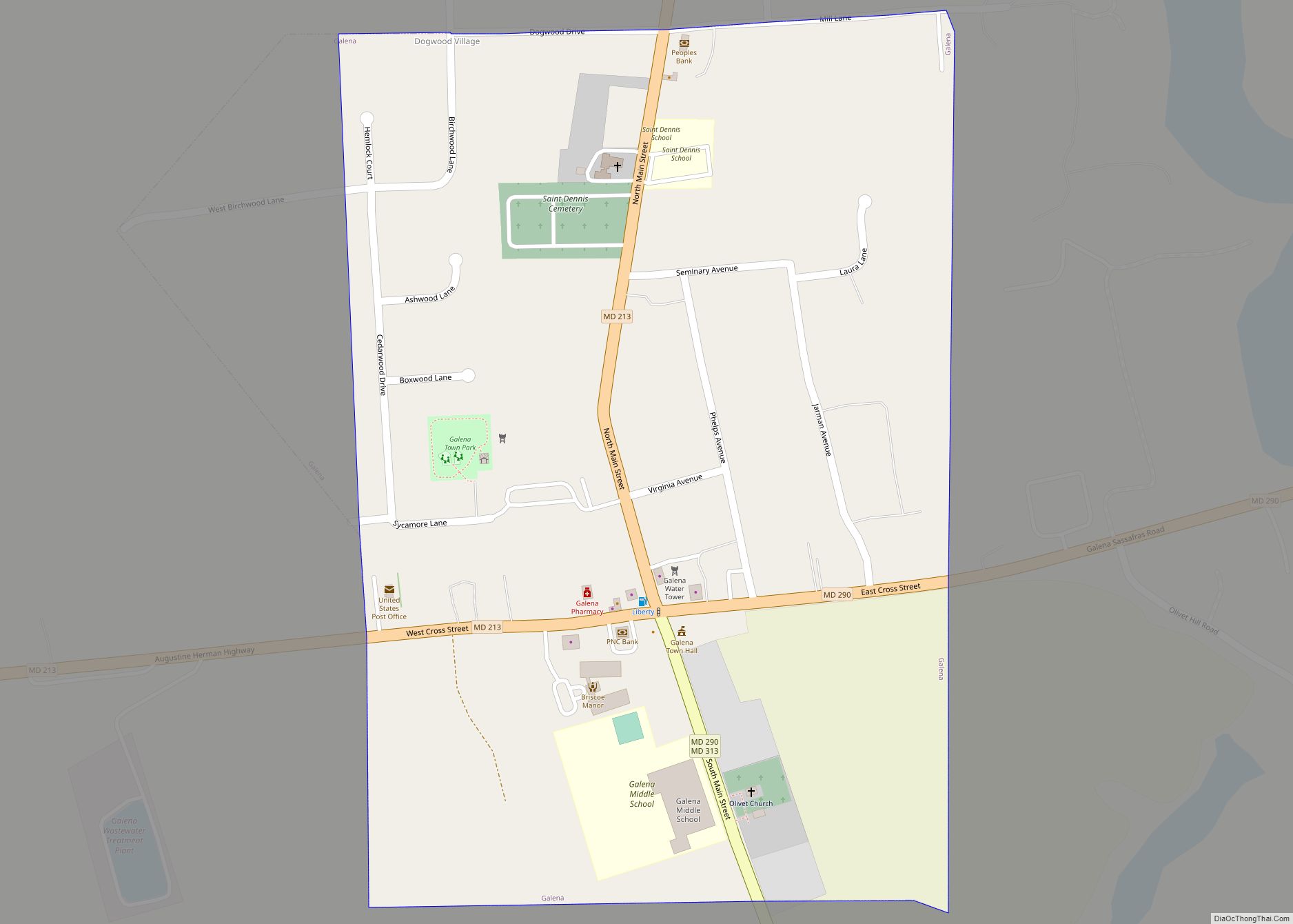
Galena is a town in Kent County, Maryland, United States. The population was 612 at the 2010 census. Galena town overview: Name: Galena town LSAD Code: 43 LSAD Description: town (suffix) State: Maryland County: Kent County Incorporated: 1858 Elevation: 69 ft (21 m) Total Area: 0.36 sq mi (0.93 km²) Land Area: 0.36 sq mi (0.93 km²) Water Area: 0.00 sq mi (0.00 km²) Total Population: … Read more

Map of Gaithersburg city

Map of Gaithersburg city

Gaithersburg (/ˈɡeɪθərzbɜːrɡ/ (listen) GAY-thərz-burg), officially the City of Gaithersburg, is a city in Montgomery County, Maryland, United States. At the time of the 2020 U.S. Census, Gaithersburg had a population of 69,657, making it the ninth-largest location in the state. Gaithersburg is located to the northwest of Washington, and is considered a suburb and a … Read more

Map of Funkstown town

Map of Funkstown town

Funkstown is a town in Washington County, Maryland, United States. The population was 904 at the 2010 census. Funkstown town overview: Name: Funkstown town LSAD Code: 43 LSAD Description: town (suffix) State: Maryland County: Washington County Incorporated: 1840 Elevation: 495 ft (151 m) Total Area: 0.55 sq mi (1.43 km²) Land Area: 0.55 sq mi (1.43 km²) Water Area: 0.00 sq mi (0.00 km²) Total Population: … Read more

Map of Gambrills CDP

Map of Gambrills CDP

Gambrills refers to two neighboring places in Anne Arundel County, Maryland, United States, located in the Annapolis metro area: the unincorporated community of Gambrills, and the Gambrills census-designated place (CDP). The area was named after Augustine Gambrill, plantation owner. The CDP covers an expansive range that falls within the communities of Crofton, Waugh Chapel, and … Read more

Map of Galesville CDP

Map of Galesville CDP, Maryland

Galesville is an unincorporated town and census-designated place (CDP) in Anne Arundel County, Maryland, United States. As of the 2010 census, it had a population of 685. Galesville is located at 38°50’35” north, 76°32’37” west (38.8431707 -76.5435702), along the western shore of the West River, an arm of the Chesapeake Bay. By road it is … Read more

Map of Galestown town

Map of Galestown town

Galestown is a town in Dorchester County, Maryland, United States. The population was 138 at the 2010 census. Galestown town overview: Name: Galestown town LSAD Code: 43 LSAD Description: town (suffix) State: Maryland County: Dorchester County Incorporated: 1951 Elevation: 13 ft (4 m) Total Area: 0.26 sq mi (0.66 km²) Land Area: 0.23 sq mi (0.61 km²) Water Area: 0.02 sq mi (0.05 km²) Total Population: … Read more

Map of Garretts Mill CDP

Map of Garretts Mill CDP

Garretts Mill is an unincorporated community and census-designated place in Washington County, Maryland, United States. Its population was 234 as of the 2010 census. Garretts Mill CDP overview: Name: Garretts Mill CDP LSAD Code: 57 LSAD Description: CDP (suffix) State: Maryland County: Washington County Total Area: 0.57 sq mi (1.48 km²) Land Area: 0.57 sq mi (1.48 km²) Water Area: 0.00 sq mi … Read more

Map of Garrett Park town

Map of Garrett Park town

Garrett Park is a town in Montgomery County, Maryland. It was named after a former president of the Baltimore and Ohio Railroad, Robert W. Garrett. The population was 992 at the 2010 census. Garrett Park is home to Garrett Park Elementary School, located just outside the town proper. Garrett Park town overview: Name: Garrett Park … Read more

Map of Gapland CDP

Map of Gapland CDP

Gapland is an unincorporated community and census-designated place in Washington County, Maryland, United States. Its population was 109 as of the 2010 census. Gapland CDP overview: Name: Gapland CDP LSAD Code: 57 LSAD Description: CDP (suffix) State: Maryland County: Washington County Elevation: 617 ft (188 m) Total Area: 0.22 sq mi (0.58 km²) Land Area: 0.22 sq mi (0.58 km²) Water Area: 0.00 sq mi … Read more

Map of Gilmore CDP, Maryland

Map of Gilmore CDP, Maryland

Gilmore is an unincorporated community and census-designated place (CDP) in Allegany County, Maryland, United States. As of the 2010 census it had a population of 127. It is part of the Cumberland, MD-WV Metropolitan Statistical Area. Gilmore lies in the valley of Georges Creek, a tributary of the North Branch Potomac River, between Dans Mountain … Read more

Map of Georgetown CDP, Maryland

Map of Georgetown CDP, Maryland

Georgetown is an unincorporated community and census-designated place in western Kent County, Maryland, United States.Per the 2020 census, the population was 117. It should not be confused with the community of the same name 22 miles (35 km) to the northeast on the Kent/Cecil County border. Georgetown CDP overview: Name: Georgetown CDP LSAD Code: 57 LSAD … Read more

Map of Garrison CDP, Maryland

Map of Garrison CDP, Maryland

Garrison is a census-designated place (CDP) in Baltimore County, Maryland, United States, adjacent to Owings Mills. It consists mainly of the McDonogh area and Valley Centre. The population was 8,823 at the 2010 census. Garrison CDP overview: Name: Garrison CDP LSAD Code: 57 LSAD Description: CDP (suffix) State: Maryland County: Baltimore County Elevation: 443 ft (135 m) … Read more