Map of Wilson-Conococheague CDP

Map of Wilson-Conococheague CDP

Wilson-Conococheague is a census-designated place (CDP) in Washington County, Maryland, United States. The population was 2,262 at the 2020 census. Wilson-Conococheague CDP overview: Name: Wilson-Conococheague CDP LSAD Code: 57 LSAD Description: CDP (suffix) State: Maryland County: Washington County Total Area: 4.84 sq mi (12.55 km²) Land Area: 4.72 sq mi (12.22 km²) Water Area: 0.13 sq mi (0.32 km²) Total Population: 2,262 Population Density: … Read more

Map of Williston CDP, Maryland

Map of Williston CDP, Maryland

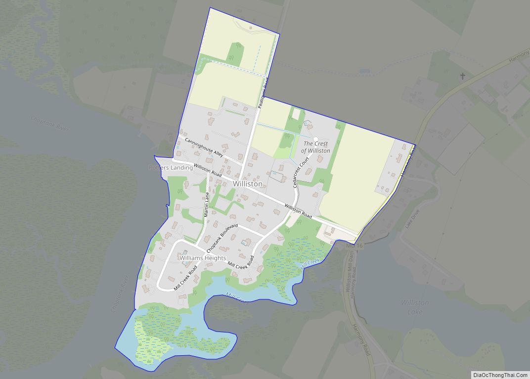
Williston is an unincorporated town and census-designated place on the Eastern Shore of the U.S. state of Maryland, in Caroline County. As of the 2010 census it had a population of 155. It is situated between Maryland Route 16 on its eastern edge and the Choptank River on its west. It was originally known as … Read more

Map of Williamsport town, Maryland

Map of Williamsport town, Maryland

Williamsport is a town in Washington County, Maryland, United States. The population was 1,868 at the 2000 census and 2,137 as of 2010. Williamsport town overview: Name: Williamsport town LSAD Code: 43 LSAD Description: town (suffix) State: Maryland County: Washington County Incorporated: 1823 Elevation: 407 ft (124 m) Total Area: 0.98 sq mi (2.55 km²) Land Area: 0.98 sq mi (2.55 km²) Water … Read more

Map of Woodmore CDP

Map of Woodmore CDP

Woodmore is an unincorporated area and census-designated place (CDP 86710) in Prince George’s County, Maryland, United States. Per the 2020 census, the population was 4,513. The CDP is located within the boundaries of Route 193 (Enterprise Road) to the west, Church Road to the east, Route 214 (Central Avenue) to the south and Route 50 … Read more

Map of Woodlawn CDP, Maryland

Map of Woodlawn CDP, Maryland

Woodlawn is an unincorporated area and census-designated place (CDP) in Prince George’s County, Maryland, United States. As of the 2020 census it had a population of 7,541. Woodlawn CDP overview: Name: Woodlawn CDP LSAD Code: 57 LSAD Description: CDP (suffix) State: Maryland County: Prince George’s County Total Area: 1.15 sq mi (2.97 km²) Land Area: 1.15 sq mi (2.96 km²) Water … Read more

Map of Woodland CDP, Maryland

Map of Woodland CDP, Maryland

Woodland is an unincorporated community and census-designated place (CDP) in Allegany County, Maryland, United States. As of the 2010 census it had a population of 113. It is located 4 miles (6 km) south of Frostburg and just east of the community called Klondike. Woodland started as a coal town sometime around the beginning of the … Read more

Map of Yarrowsburg CDP

Map of Yarrowsburg CDP

Yarrowsburg is an unincorporated community and census-designated place in Washington County, Maryland, United States. Its population was 133 as of the 2010 census. Yarrowsburg CDP overview: Name: Yarrowsburg CDP LSAD Code: 57 LSAD Description: CDP (suffix) State: Maryland County: Washington County Total Area: 0.23 sq mi (0.59 km²) Land Area: 0.23 sq mi (0.59 km²) Water Area: 0.00 sq mi (0.00 km²) Total Population: … Read more

Map of Worton CDP

Map of Worton CDP

Worton is an unincorporated community and census-designated place (CDP) in Kent County, Maryland, United States. As of the 2010 census it had a population of 249. The Christ Church, Graveyard and Sexton’s House complex was listed on the National Register of Historic Places in 1980. Worton CDP overview: Name: Worton CDP LSAD Code: 57 LSAD … Read more

Map of Woodsboro town

Map of Woodsboro town, Maryland

Woodsboro is a town in Frederick County, Maryland, United States that was granted to Joseph Wood in 1693. The population was 1,141 at the 2010 census. Woodsboro town overview: Name: Woodsboro town LSAD Code: 43 LSAD Description: town (suffix) State: Maryland County: Frederick County Founded: 1786 Incorporated: 1836 Elevation: 397 ft (121 m) Total Area: 0.71 sq mi (1.84 km²) … Read more

Map of Zihlman CDP

Map of Zihlman CDP

Zihlman (formerly Allegany) is an unincorporated community and census-designated place (CDP) in Allegany County, Maryland, United States. As of the 2010 census it had a population of 362. Zihlman is located along Maryland Route 36, 1.5 miles (2.4 km) northeast of and 500 feet (150 m) lower in elevation than Frostburg. Mount Savage is 3 miles (5 km) … Read more