Map of Provincetown CDP

Map of Provincetown CDP

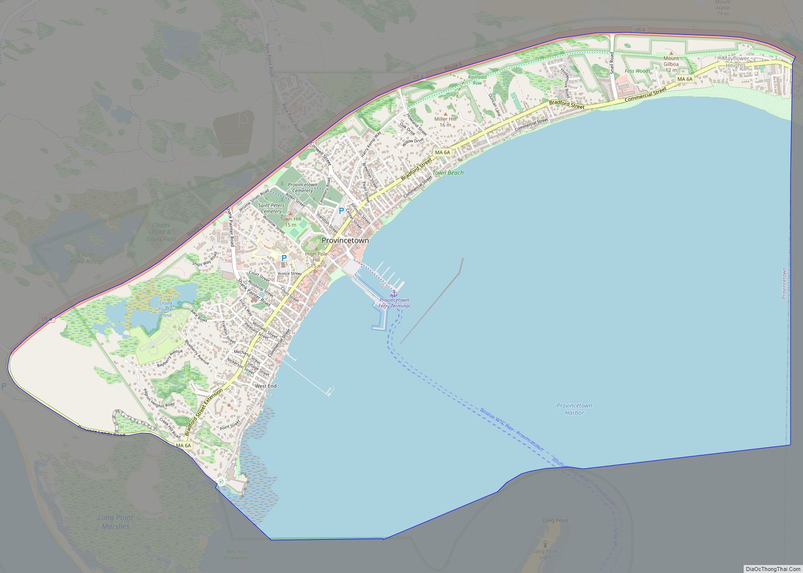
Provincetown (CDP) is a census-designated place (CDP) in the town of Provincetown in Barnstable County, Massachusetts, United States. The population was 2,642 at the 2010 census, out of 2,942 in the entire town. Provincetown CDP overview: Name: Provincetown CDP LSAD Code: 57 LSAD Description: CDP (suffix) State: Massachusetts County: Barnstable County Elevation: 0 ft (0 m) Total … Read more

Map of Popponesset CDP

Map of Popponesset CDP

Popponesset is a census-designated place (CDP) in the town of Mashpee on Cape Cod in Barnstable County, Massachusetts, United States. The population was 220 at the 2010 census. Popponesset CDP overview: Name: Popponesset CDP LSAD Code: 57 LSAD Description: CDP (suffix) State: Massachusetts County: Barnstable County Elevation: 13 ft (4 m) Total Area: 0.32 sq mi (0.82 km²) Land Area: … Read more

Map of Reading CDP, Massachusetts

Map of Reading CDP, Massachusetts

Reading (/ˈrɛdɪŋ/ (listen) RED-ing) is a town in Middlesex County, Massachusetts, United States, 16 miles (26 km) north of central Boston. The population was 25,518 at the 2020 census. Reading CDP overview: Name: Reading CDP LSAD Code: 57 LSAD Description: CDP (suffix) State: Massachusetts County: Middlesex County Elevation: 127 ft (39 m) Total Area: 9.9 sq mi (25.7 km²) Land Area: … Read more

Map of Raynham Center CDP

Map of Raynham Center CDP

Raynham Center is a census-designated place (CDP) in the town of Raynham in Bristol County, Massachusetts, United States. The population was 4,100 at the 2010 census. Raynham Center CDP overview: Name: Raynham Center CDP LSAD Code: 57 LSAD Description: CDP (suffix) State: Massachusetts County: Bristol County Elevation: 39 ft (12 m) Total Area: 4.34 sq mi (11.25 km²) Land Area: … Read more

Map of Randolph Town city

Map of Randolph Town city

Randolph Town city overview: Name: Randolph Town city LSAD Code: 25 LSAD Description: city (suffix) State: Massachusetts FIPS code: 2556000 Online Interactive Map Randolph Town online map. Source: Basemap layers from Google Map, Open Street Map (OSM), Arcgisonline, Wmflabs. Boundary Data from Database of Global Administrative Areas. Randolph Town location map. Where is Randolph Town … Read more

Map of Rockport CDP, Massachusetts

Map of Rockport CDP, Massachusetts

Rockport is a census-designated place (CDP) in the town of Rockport in Essex County, Massachusetts, United States. The population was 4,966 at the 2010 census. Rockport CDP overview: Name: Rockport CDP LSAD Code: 57 LSAD Description: CDP (suffix) State: Massachusetts County: Essex County Elevation: 52 ft (16 m) Total Area: 4.09 sq mi (10.59 km²) Land Area: 3.98 sq mi (10.31 km²) Water … Read more

Map of Revere city

Map of Revere city, Massachusetts

Revere is a city in Suffolk County, Massachusetts, located approximately 5 miles (8.0 km) from downtown Boston. Founded as North Chelsea in 1846, it was renamed in 1871 after Revolutionary War patriot Paul Revere. In 1914, the Town of Revere was incorporated as a city. At the 2020 census, the city had a population of 62,186 … Read more

Map of Rowley CDP, Massachusetts

Map of Rowley CDP, Massachusetts

Rowley is a census-designated place (CDP) in the town of Rowley in Essex County, Massachusetts, United States. The population was 1,416 at the 2010 census. Rowley CDP overview: Name: Rowley CDP LSAD Code: 57 LSAD Description: CDP (suffix) State: Massachusetts County: Essex County Elevation: 46 ft (14 m) Total Area: 1.74 sq mi (4.51 km²) Land Area: 1.71 sq mi (4.44 km²) Water … Read more

Map of Sagamore CDP

Map of Sagamore CDP

Sagamore is a census-designated place (CDP) in the town of Bourne in Barnstable County, Massachusetts, United States. The population was 3,623 at the 2010 census. “Sagamore” was one of the words used by northeastern Native Americans to designate an elected chief or leader. Sagamore CDP overview: Name: Sagamore CDP LSAD Code: 57 LSAD Description: CDP … Read more

Map of Rutland CDP, Massachusetts

Map of Rutland CDP, Massachusetts

Rutland is a census-designated place (CDP) in the town of Rutland in Worcester County, Massachusetts, United States. The population was 2,111 at the 2010 census. Rutland CDP overview: Name: Rutland CDP LSAD Code: 57 LSAD Description: CDP (suffix) State: Massachusetts County: Worcester County Elevation: 1,125 ft (343 m) Total Area: 3.19 sq mi (8.27 km²) Land Area: 2.96 sq mi (7.66 km²) Water … Read more

Map of Russell CDP, Massachusetts

Map of Russell CDP, Massachusetts

Russell is a census-designated place that comprises the populated center of the town of Russell in Hampden County, Massachusetts, United States. The population of the CDP was 786 at the 2010 census, out of 1,775 in the entire town of Russell. It is part of the Springfield, Massachusetts Metropolitan Statistical Area. Russell CDP overview: Name: … Read more

Map of Sandwich CDP, Massachusetts

Map of Sandwich CDP, Massachusetts

Sandwich is a village and census-designated place (CDP) in the town of Sandwich in Barnstable County, Massachusetts, United States. The population was 2,962 at the 2010 census, out of a total 20,675 people in the town of Sandwich. Sandwich CDP overview: Name: Sandwich CDP LSAD Code: 57 LSAD Description: CDP (suffix) State: Massachusetts County: Barnstable … Read more