Map of Ware CDP

Map of Ware CDP

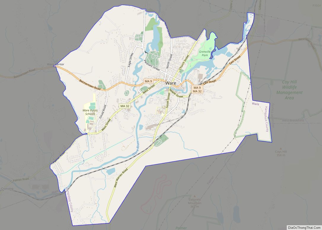
Ware is a census-designated place (CDP) comprising the main village in the town of Ware in Hampshire County, Massachusetts, United States. The population of the CDP was 6,170 at the 2010 census, out of a total town population of 9,872. It is part of the Springfield, Massachusetts Metropolitan Statistical Area. Ware CDP overview: Name: Ware … Read more

Map of Waltham city

Map of Waltham city, Massachusetts

Waltham (/ˈwɔːlθæm/ WAWL-tham) is a city in Middlesex County, Massachusetts, United States, and was an early center for the labor movement as well as a major contributor to the American Industrial Revolution. The original home of the Boston Manufacturing Company, the city was a prototype for 19th century industrial city planning, spawning what became known … Read more

Map of Webster CDP, Massachusetts

Map of Webster CDP, Massachusetts

Webster is a census-designated place (CDP) in the town of Webster in Worcester County, Massachusetts, United States. The population was 11,412 at the 2010 census. Webster CDP overview: Name: Webster CDP LSAD Code: 57 LSAD Description: CDP (suffix) State: Massachusetts County: Worcester County Elevation: 463 ft (141 m) Total Area: 3.03 sq mi (7.84 km²) Land Area: 2.97 sq mi (7.69 km²) Water … Read more

Map of Watertown Town city

Map of Watertown Town city

Watertown Town city overview: Name: Watertown Town city LSAD Code: 25 LSAD Description: city (suffix) State: Massachusetts County: Middlesex County FIPS code: 2573440 Online Interactive Map Watertown Town online map. Source: Basemap layers from Google Map, Open Street Map (OSM), Arcgisonline, Wmflabs. Boundary Data from Database of Global Administrative Areas. Watertown Town location map. Where … Read more

Map of Warren CDP, Massachusetts

Map of Warren CDP, Massachusetts

Warren is a census-designated place (CDP) in the town of Warren in Worcester County, Massachusetts, United States. The population was 1,405 at the 2010 census. Warren CDP overview: Name: Warren CDP LSAD Code: 57 LSAD Description: CDP (suffix) State: Massachusetts County: Worcester County Elevation: 633 ft (193 m) Total Area: 1.30 sq mi (3.36 km²) Land Area: 1.28 sq mi (3.33 km²) Water … Read more

Map of West Chatham CDP

Map of West Chatham CDP

West Chatham is a census-designated place (CDP) in the town of Chatham in Barnstable County, Massachusetts, United States. The population was 1,410 at the 2010 census. West Chatham CDP overview: Name: West Chatham CDP LSAD Code: 57 LSAD Description: CDP (suffix) State: Massachusetts County: Barnstable County Elevation: 49 ft (15 m) Total Area: 3.32 sq mi (8.60 km²) Land Area: … Read more

Map of West Brookfield CDP

Map of West Brookfield CDP

West Brookfield is a census-designated place (CDP) in the town of West Brookfield in Worcester County, Massachusetts, United States. The population was 1,413 at the 2010 census. West Brookfield CDP overview: Name: West Brookfield CDP LSAD Code: 57 LSAD Description: CDP (suffix) State: Massachusetts County: Worcester County Elevation: 627 ft (191 m) Total Area: 1.77 sq mi (4.58 km²) Land … Read more

Map of Wellesley CDP

Map of Wellesley CDP

Wellesley (/ˈwɛlzlɪ/) is a town in Norfolk County, Massachusetts, United States. Wellesley is part of Greater Boston. The population was 29,550 at the time of the 2020 census. Wellesley College, Babson College, and a campus of Massachusetts Bay Community College are located in the town. Wellesley CDP overview: Name: Wellesley CDP LSAD Code: 57 LSAD … Read more

Map of West Falmouth CDP

Map of West Falmouth CDP

West Falmouth is a census-designated place (CDP) in the town of Falmouth in Barnstable County, Massachusetts, United States. The population was 1,738 at the 2010 census. West Falmouth Village Historic District is at the heart of West Falmouth Village. Historic buildings include the West Falmouth Library, Quaker Meeting House and Quaker Carriage Sheds, Emerson House, … Read more

Map of West Dennis CDP

Map of West Dennis CDP

West Dennis is a census-designated place (CDP) in the town of Dennis in Barnstable County, Massachusetts, United States. The population was 2,242 at the 2010 census. West Dennis CDP overview: Name: West Dennis CDP LSAD Code: 57 LSAD Description: CDP (suffix) State: Massachusetts County: Barnstable County Elevation: 10 ft (3 m) Total Area: 4.21 sq mi (10.90 km²) Land Area: … Read more

Map of West Concord CDP

Map of West Concord CDP, Massachusetts

West Concord is an unincorporated village and census-designated place (CDP) in the town of Concord in Middlesex County, Massachusetts, United States. The population was 6,028 at the 2010 census. West Concord CDP overview: Name: West Concord CDP LSAD Code: 57 LSAD Description: CDP (suffix) State: Massachusetts County: Middlesex County Elevation: 118 ft (36 m) Total Area: 3.58 sq mi … Read more

Map of West Springfield Town city

Map of West Springfield Town city

West Springfield Town city overview: Name: West Springfield Town city LSAD Code: 25 LSAD Description: city (suffix) State: Massachusetts County: Hampden County FIPS code: 2577890 Online Interactive Map West Springfield Town online map. Source: Basemap layers from Google Map, Open Street Map (OSM), Arcgisonline, Wmflabs. Boundary Data from Database of Global Administrative Areas. West Springfield … Read more