Map of Andover CDP, Massachusetts

Map of Andover CDP, Massachusetts

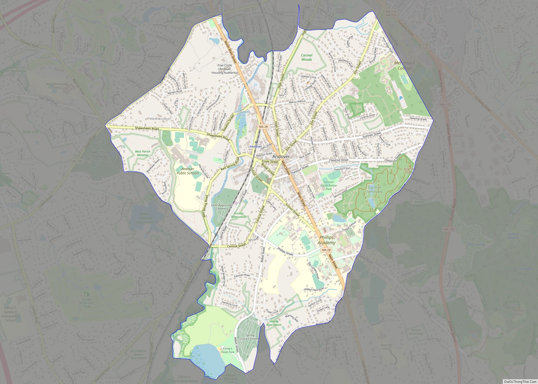
Andover is a census-designated place (CDP) in the town of Andover in Essex County, Massachusetts, United States. The population was 8,762 at the 2010 census. Andover CDP overview: Name: Andover CDP LSAD Code: 57 LSAD Description: CDP (suffix) State: Massachusetts County: Essex County Elevation: 184 ft (56 m) Total Area: 3.77 sq mi (9.76 km²) Land Area: 3.69 sq mi (9.55 km²) Water … Read more

Map of Amherst Center CDP

Map of Amherst Center CDP

Amherst Center CDP overview: Name: Amherst Center CDP LSAD Code: 57 LSAD Description: CDP (suffix) State: Massachusetts County: Hampshire County FIPS code: 2501360 Online Interactive Map Amherst Center online map. Source: Basemap layers from Google Map, Open Street Map (OSM), Arcgisonline, Wmflabs. Boundary Data from Database of Global Administrative Areas. Amherst Center location map. Where … Read more

Map of Ayer CDP

Map of Ayer CDP

Ayer is a census-designated place (CDP) in the town of Ayer in Middlesex County, Massachusetts, United States. The population was 2,868 at the 2010 census. Ayer CDP overview: Name: Ayer CDP LSAD Code: 57 LSAD Description: CDP (suffix) State: Massachusetts County: Middlesex County Elevation: 240 ft (73 m) Total Area: 1.39 sq mi (3.60 km²) Land Area: 1.33 sq mi (3.43 km²) Water … Read more

Map of Attleboro city

Map of Attleboro city

Attleboro is a city in Bristol County, Massachusetts, United States. It was once known as “The Jewelry Capital of the World” for its many jewelry manufacturers. According to the 2020 census, Attleboro had a population of 46,461. Attleboro city overview: Name: Attleboro city LSAD Code: 25 LSAD Description: city (suffix) State: Massachusetts County: Bristol County … Read more

Map of Athol CDP, Massachusetts

Map of Athol CDP, Massachusetts

Athol is a census-designated place (CDP) in the town of Athol in Worcester County, Massachusetts, United States. The population was 8,265 at the 2010 census. Athol CDP overview: Name: Athol CDP LSAD Code: 57 LSAD Description: CDP (suffix) State: Massachusetts County: Worcester County Elevation: 558 ft (170 m) Total Area: 8.47 sq mi (21.93 km²) Land Area: 8.19 sq mi (21.20 km²) Water … Read more

Map of Barre CDP

Map of Barre CDP, Massachusetts

Barre is a census-designated place (CDP) in the town of Barre in Worcester County, Massachusetts, United States. The population was 1,009 at the 2010 census. Barre CDP overview: Name: Barre CDP LSAD Code: 57 LSAD Description: CDP (suffix) State: Massachusetts County: Worcester County Elevation: 912 ft (278 m) Total Area: 1.58 sq mi (4.10 km²) Land Area: 1.58 sq mi (4.10 km²) Water … Read more

Map of Barnstable Town city

Map of Barnstable Town city

Barnstable Town city overview: Name: Barnstable Town city LSAD Code: 25 LSAD Description: city (suffix) State: Massachusetts County: Barnstable County FIPS code: 2503690 Online Interactive Map Barnstable Town online map. Source: Basemap layers from Google Map, Open Street Map (OSM), Arcgisonline, Wmflabs. Boundary Data from Database of Global Administrative Areas. Barnstable Town location map. Where … Read more

Map of Baldwinville CDP

Map of Baldwinville CDP

Baldwinville is an unincorporated village and census-designated place (CDP) in the town of Templeton in Worcester County, Massachusetts, United States. The population was 2,028 at the 2010 census. The name also refers to the local post office or railroad station. Baldwinville CDP overview: Name: Baldwinville CDP LSAD Code: 57 LSAD Description: CDP (suffix) State: Massachusetts … Read more

Map of Belmont CDP, Massachusetts

Map of Belmont CDP, Massachusetts

Belmont is a town in Middlesex County, Massachusetts, United States. It is a western suburb of Boston, Massachusetts, United States; and is part of the Greater Boston metropolitan area. At the 2020 U.S. census, its population was 27,295, up 10.4% from 2010. Belmont CDP overview: Name: Belmont CDP LSAD Code: 57 LSAD Description: CDP (suffix) … Read more

Map of Bellingham city

Map of Bellingham CDP, Massachusetts

Bellingham is a census-designated place (CDP) in the town of Bellingham in Norfolk County, Massachusetts, United States. The population was 4,854 at the 2010 census. Bellingham CDP overview: Name: Bellingham CDP LSAD Code: 57 LSAD Description: CDP (suffix) State: Massachusetts County: Norfolk County Elevation: 295 ft (90 m) Total Area: 5.49 sq mi (14.22 km²) Land Area: 5.39 sq mi (13.96 km²) Water … Read more

Map of Belchertown CDP

Map of Belchertown CDP

Belchertown is a census-designated place (CDP) comprising the central village in the town of Belchertown in Hampshire County, Massachusetts, United States. The population was 2,899 at the 2010 census, out of a total town population of 14,649. It is part of the Springfield, Massachusetts Metropolitan Statistical Area. Belchertown CDP overview: Name: Belchertown CDP LSAD Code: … Read more

Map of Bliss Corner CDP

Map of Bliss Corner CDP

Bliss Corner is a census-designated place (CDP) in the town of Dartmouth in Bristol County, Massachusetts, United States. The population was 5,280 at the 2010 census. Bliss Corner CDP overview: Name: Bliss Corner CDP LSAD Code: 57 LSAD Description: CDP (suffix) State: Massachusetts County: Bristol County Elevation: 66 ft (20 m) Total Area: 2.00 sq mi (5.19 km²) Land Area: … Read more