Map of Wade CDP

Map of Wade CDP, Mississippi

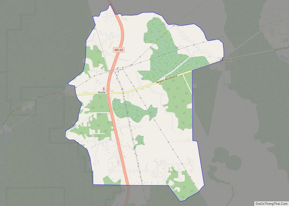
Wade is an unincorporated community and census-designated place (CDP) in Jackson County, Mississippi, United States. It is part of the Pascagoula Metropolitan Statistical Area. The population was 1,074 at the 2010 census, up from 491 at the 2000 census. Wade CDP overview: Name: Wade CDP LSAD Code: 57 LSAD Description: CDP (suffix) State: Mississippi County: … Read more

Map of Verona city, Mississippi

Map of Verona city, Mississippi

Verona is a city in Lee County, Mississippi. The population was 2,792 at the 2020 census, down from 3,006 at the 2010 census. Verona city overview: Name: Verona city LSAD Code: 25 LSAD Description: city (suffix) State: Mississippi County: Lee County Elevation: 325 ft (99 m) Total Area: 3.71 sq mi (9.60 km²) Land Area: 3.67 sq mi (9.51 km²) Water Area: 0.04 sq mi … Read more

Map of Vardaman town

Map of Vardaman town

Vardaman is a town in Calhoun County, Mississippi. The town’s population was 1,316 at the time of the 2010 United States Census. Vardaman town overview: Name: Vardaman town LSAD Code: 43 LSAD Description: town (suffix) State: Mississippi County: Calhoun County Elevation: 289 ft (88 m) Total Area: 1.36 sq mi (3.51 km²) Land Area: 1.36 sq mi (3.51 km²) Water Area: 0.00 sq mi (0.00 km²) … Read more

Map of Vancleave CDP

Map of Vancleave CDP

Vancleave is an unincorporated community and census-designated place (CDP) in Jackson County, Mississippi, United States. It is part of the Pascagoula Metropolitan Statistical Area. The population was 5,886 at the 2010 census, up from 4,910 at the 2000 census. Vancleave CDP overview: Name: Vancleave CDP LSAD Code: 57 LSAD Description: CDP (suffix) State: Mississippi County: … Read more

Map of Vaiden town

Map of Vaiden town

Vaiden is a town in Carroll County, Mississippi, United States and its first county seat. The population was 734 at the 2010 census. It is part of the Greenwood, Mississippi micropolitan area. Vaiden town overview: Name: Vaiden town LSAD Code: 43 LSAD Description: town (suffix) State: Mississippi County: Carroll County Elevation: 312 ft (95 m) Total Area: … Read more

Map of Walthall village

Map of Walthall village

Walthall is a village in Webster County, Mississippi. The population was 144 at the 2010 census. It is the county seat of Webster County, designated in 1876. Walthall village overview: Name: Walthall village LSAD Code: 47 LSAD Description: village (suffix) State: Mississippi County: Webster County Elevation: 466 ft (142 m) Total Area: 0.98 sq mi (2.53 km²) Land Area: 0.97 sq mi … Read more

Map of Walnut town, Mississippi

Map of Walnut town, Mississippi

Walnut is a town in Tippah County, Mississippi, United States. The population was 771 at the 2010 census. Walnut town overview: Name: Walnut town LSAD Code: 43 LSAD Description: town (suffix) State: Mississippi County: Tippah County Elevation: 459 ft (140 m) Total Area: 5.45 sq mi (14.12 km²) Land Area: 5.43 sq mi (14.06 km²) Water Area: 0.02 sq mi (0.06 km²) Total Population: 704 Population … Read more

Map of Walnut Grove town, Mississippi

Map of Walnut Grove town, Mississippi

Walnut Grove is a town in Leake County, Mississippi, United States. The population was 510 at the 2020 census, a sharp decrease from 1,911 at the 2010 census, due to the Walnut Grove Youth Correctional Facility being closed by the state in September 2016 because of repeated problems at the troubled facility. It had been … Read more

Map of Walls town

Map of Walls town

Walls is a town located in northern DeSoto County, Mississippi, United States, near the Mississippi River, part of the larger region known as “The Delta”, and known for its rich, dark soil. As it is in the upper northwest corner of Mississippi, it is in the Memphis, Tennessee metropolitan area. Its ZIP code is 38680. … Read more

Map of Water Valley city, Mississippi

Map of Water Valley city, Mississippi

Water Valley is a city in Yalobusha County, Mississippi, United States. The population was 3,392 at the 2010 census. It is the larger of two county seats in the rural county, and at one time was the center of railroad shops. Water Valley city overview: Name: Water Valley city LSAD Code: 25 LSAD Description: city … Read more

Map of Wesson town

Map of Wesson town

Wesson is a town in Copiah and Lincoln counties, Mississippi, United States. The population was 1,925 at the 2010 census. It is part of the Jackson Metropolitan Statistical Area. Wesson town overview: Name: Wesson town LSAD Code: 43 LSAD Description: town (suffix) State: Mississippi County: Copiah County, Lincoln County Elevation: 466 ft (142 m) Total Area: 4.51 sq mi … Read more

Map of Weir town, Mississippi

Map of Weir town, Mississippi

Weir is a town in Choctaw County, Mississippi, United States. The population was 459 at the 2010 census, down from 553 at the 2000 census. Weir town overview: Name: Weir town LSAD Code: 43 LSAD Description: town (suffix) State: Mississippi County: Choctaw County Elevation: 472 ft (144 m) Total Area: 1.07 sq mi (2.76 km²) Land Area: 1.05 sq mi (2.72 km²) Water … Read more