Map of Durant city, Mississippi

Map of Durant city, Mississippi

Durant is a city near the central eastern border of Holmes County, Mississippi, United States, and Big Black River. The town was founded in 1858 as a station on the Mississippi Central Railroad, later part of the Illinois Central. Durant was named for Louis Durant, a Choctaw chief who had lived on this site before … Read more

Map of Duncan town, Mississippi

Map of Duncan town, Mississippi

Duncan is a town in Bolivar County, Mississippi, United States. Per the 2020 census, the population was 276. Duncan town overview: Name: Duncan town LSAD Code: 43 LSAD Description: town (suffix) State: Mississippi County: Bolivar County Elevation: 154 ft (47 m) Total Area: 0.92 sq mi (2.37 km²) Land Area: 0.92 sq mi (2.37 km²) Water Area: 0.00 sq mi (0.00 km²) Total Population: 276 Population … Read more

Map of Edwards town, Mississippi

Map of Edwards town, Mississippi

Edwards is a town in Hinds County, Mississippi, United States. The population was 1,034 at the 2010 census, down from 1,347 at the 2000 census. It is part of the Jackson Metropolitan Statistical Area. Edwards town overview: Name: Edwards town LSAD Code: 43 LSAD Description: town (suffix) State: Mississippi County: Hinds County Elevation: 236 ft (72 m) … Read more

Map of Eden village, Mississippi

Map of Eden village, Mississippi

Eden is a village in Yazoo County, Mississippi. Per the 2020 Census, the population was 133. Eden village overview: Name: Eden village LSAD Code: 47 LSAD Description: village (suffix) State: Mississippi County: Yazoo County Elevation: 112 ft (34 m) Total Area: 0.47 sq mi (1.23 km²) Land Area: 0.47 sq mi (1.23 km²) Water Area: 0.00 sq mi (0.00 km²) Total Population: 133 Population Density: 281.18/sq mi … Read more

Map of Ecru town

Map of Ecru town

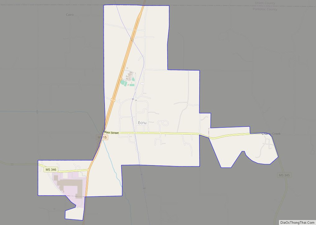
Ecru is a town in Pontotoc County, Mississippi. The population was 895 at the 2010 census. Ecru is home to the largest upholstered furniture plant in the world which manufactures Ashley Furniture. Ecru town overview: Name: Ecru town LSAD Code: 43 LSAD Description: town (suffix) State: Mississippi County: Pontotoc County Elevation: 387 ft (118 m) Total Area: … Read more

Map of Ethel town, Mississippi

Map of Ethel town, Mississippi

Ethel is a U.S. town in Attala County, Mississippi. The population was 418 at the 2010 census. Ethel town overview: Name: Ethel town LSAD Code: 43 LSAD Description: town (suffix) State: Mississippi County: Attala County Elevation: 423 ft (129 m) Total Area: 0.58 sq mi (1.51 km²) Land Area: 0.58 sq mi (1.51 km²) Water Area: 0.00 sq mi (0.00 km²) Total Population: 348 Population Density: … Read more

Map of Escatawpa CDP

Map of Escatawpa CDP

Escatawpa is an unincorporated community and census-designated place (CDP) in Jackson County, Mississippi, United States. It is part of the Pascagoula Metropolitan Statistical Area. The population was 3,254 at the 2020 census. Escatawpa CDP overview: Name: Escatawpa CDP LSAD Code: 57 LSAD Description: CDP (suffix) State: Mississippi County: Jackson County Elevation: 13 ft (4 m) Total Area: … Read more

Map of Enterprise town, Mississippi

Map of Enterprise town, Mississippi

Enterprise is a town in Clarke County, Mississippi, United States. The population was 526 at the 2010 census. Enterprise town overview: Name: Enterprise town LSAD Code: 43 LSAD Description: town (suffix) State: Mississippi County: Clarke County Elevation: 259 ft (79 m) Total Area: 2.46 sq mi (6.37 km²) Land Area: 2.45 sq mi (6.35 km²) Water Area: 0.01 sq mi (0.02 km²) Total Population: 496 Population … Read more

Map of Ellisville city, Mississippi

Map of Ellisville city, Mississippi

Ellisville is a town in and the first county seat of Jones County, Mississippi, United States. The population was 4,448 at the time of the 2010 census, up from 3,465 at the 2000 census. The Jones County Courthouse is located here, as is much of the county government. The state legislature authorized a second county … Read more

Map of Elliott CDP, Mississippi

Map of Elliott CDP, Mississippi

Elliott is an unincorporated community and census-designated place (CDP) in Grenada County, Mississippi, United States, and part of the Grenada Micropolitan Statistical Area. As of the 2010 census it had a population of 990. Elliott is located on the southern edge of Grenada County, with its southern border following the Montgomery County line. It is … Read more

Map of Farrell CDP

Map of Farrell CDP, Mississippi

Farrell is an unincorporated community and census-designated place in Coahoma County, Mississippi, United States. Per the 2020 census, the population was 200. Farrell is located approximately 4 miles (6 km) south of Stovall and 4 miles (6 km) north of Sherard on Mississippi Highway 1. It is approximately 9 miles (14 km) northwest of Clarksdale, the county seat. … Read more

Map of Farmington town, Mississippi

Map of Farmington town, Mississippi

Farmington is a town in Alcorn County, Mississippi. The population was 2,186 at the 2010 census. Farmington town overview: Name: Farmington town LSAD Code: 43 LSAD Description: town (suffix) State: Mississippi County: Alcorn County Elevation: 522 ft (159 m) Total Area: 6.40 sq mi (16.56 km²) Land Area: 6.38 sq mi (16.53 km²) Water Area: 0.01 sq mi (0.04 km²) Total Population: 2,055 Population Density: 322.05/sq mi … Read more