Map of Bolivar city

Map of Bolivar city, Missouri

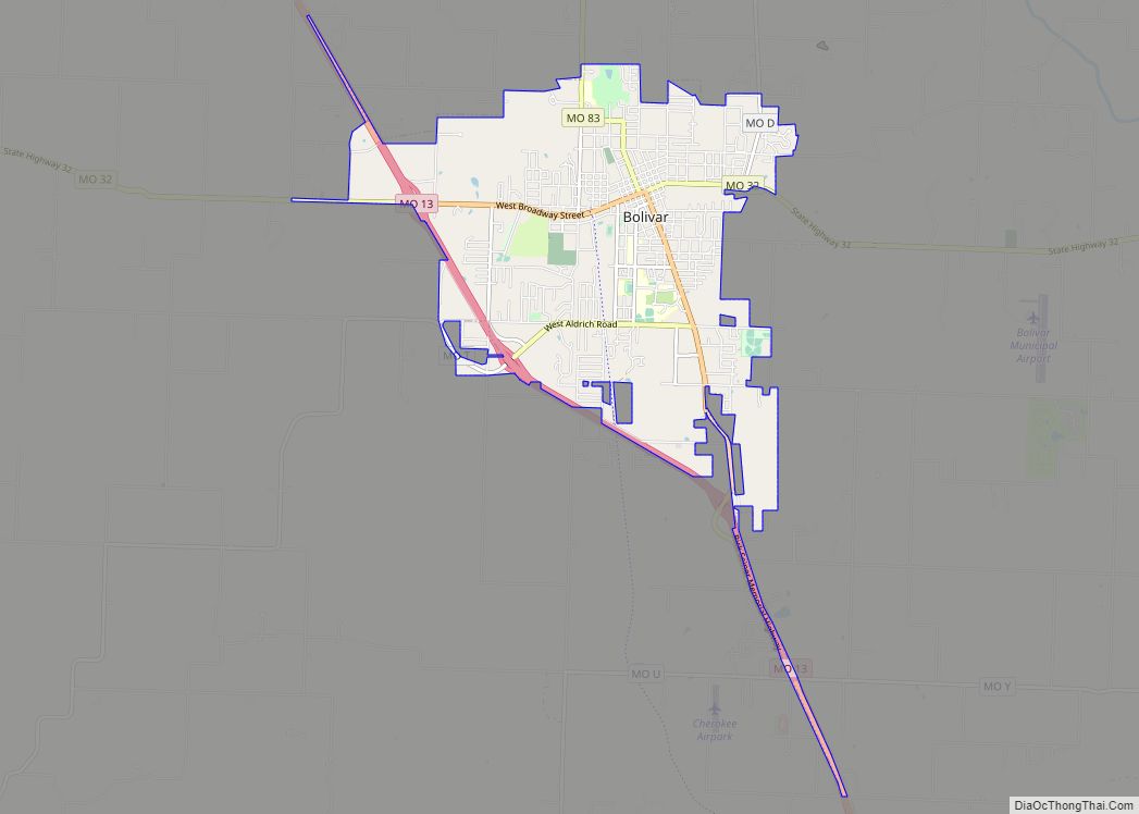
Bolivar is a city and county seat of Polk County, Missouri, United States. As of a 2019 estimate by the U. S. Census Bureau, the city population was 11,067. Bolivar city overview: Name: Bolivar city LSAD Code: 25 LSAD Description: city (suffix) State: Missouri County: Polk County Elevation: 1,070 ft (330 m) Total Area: 8.24 sq mi (21.34 km²) Land … Read more

Map of Bolckow city

Map of Bolckow city

Bolckow is a city in Benton Township, Andrew County, Missouri, United States. The population was 187 at the 2010 Census. It is part of the St. Joseph, MO–KS Metropolitan Statistical Area. Bolckow city overview: Name: Bolckow city LSAD Code: 25 LSAD Description: city (suffix) State: Missouri County: Andrew County Elevation: 951 ft (290 m) Total Area: 0.33 sq mi … Read more

Map of Bourbon city, Missouri

Map of Bourbon city, Missouri

Bourbon is a city in Crawford County, Missouri, United States. At the time of the 2010 census, it had a population of 1,632. Bourbon city overview: Name: Bourbon city LSAD Code: 25 LSAD Description: city (suffix) State: Missouri County: Crawford County Elevation: 938 ft (286 m) Total Area: 1.34 sq mi (3.46 km²) Land Area: 1.34 sq mi (3.46 km²) Water Area: 0.00 sq mi … Read more

Map of Bosworth city

Map of Bosworth city

Bosworth is a city in Carroll County, Missouri, United States. The population was 213 at the 2020 U.S. Census. Bosworth city overview: Name: Bosworth city LSAD Code: 25 LSAD Description: city (suffix) State: Missouri County: Carroll County Elevation: 764 ft (233 m) Total Area: 0.55 sq mi (1.43 km²) Land Area: 0.55 sq mi (1.43 km²) Water Area: 0.00 sq mi (0.00 km²) Total Population: 213 … Read more

Map of Boonville city, Missouri

Map of Boonville city, Missouri

Boonville is a city and the county seat of Cooper County, Missouri, United States. The population was 7,964 at the 2020 census. The city was the site of a skirmish early in the Civil War, on July 17, 1861. Union forces defeated the Missouri State Guard in the first Battle of Boonville. It is part … Read more

Map of Bowling Green city, Missouri

Map of Bowling Green city, Missouri

Bowling Green is a city in Pike County, Missouri, United States. The population was 5,334 at the 2010 census. It is the county seat of Pike County. Bowling Green city overview: Name: Bowling Green city LSAD Code: 25 LSAD Description: city (suffix) State: Missouri County: Pike County Elevation: 892 ft (272 m) Total Area: 2.70 sq mi (7.00 km²) Land … Read more

Map of Brandsville city

Map of Brandsville city

Brandsville is a city in southeastern Howell County, Missouri, United States. The population was 161 at the 2010 census. Brandsville city overview: Name: Brandsville city LSAD Code: 25 LSAD Description: city (suffix) State: Missouri County: Howell County Elevation: 945 ft (288 m) Total Area: 0.52 sq mi (1.35 km²) Land Area: 0.52 sq mi (1.35 km²) Water Area: 0.00 sq mi (0.00 km²) Total Population: 127 … Read more

Map of Bragg City town

Map of Bragg City town

Bragg City is a city in Pemiscot County, Missouri, United States. The population was 72 at the 2020 census. Bragg City town overview: Name: Bragg City town LSAD Code: 43 LSAD Description: town (suffix) State: Missouri County: Pemiscot County Elevation: 259 ft (79 m) Total Area: 0.20 sq mi (0.53 km²) Land Area: 0.20 sq mi (0.53 km²) Water Area: 0.00 sq mi (0.00 km²) Total … Read more

Map of Braymer city

Map of Braymer city

Braymer is a city in southeast Caldwell County, Missouri. The population was 737 at the 2020 census. Braymer city overview: Name: Braymer city LSAD Code: 25 LSAD Description: city (suffix) State: Missouri County: Caldwell County Elevation: 774 ft (236 m) Total Area: 0.59 sq mi (1.53 km²) Land Area: 0.59 sq mi (1.53 km²) Water Area: 0.00 sq mi (0.00 km²) Total Population: 737 Population Density: … Read more

Map of Brashear city

Map of Brashear city

Brashear is a city in Salt River Township, Adair County, Missouri, United States. The population was 273 at the 2010 census. Brashear city overview: Name: Brashear city LSAD Code: 25 LSAD Description: city (suffix) State: Missouri County: Adair County Elevation: 873 ft (266 m) Total Area: 0.35 sq mi (0.91 km²) Land Area: 0.35 sq mi (0.91 km²) Water Area: 0.00 sq mi (0.00 km²) Total … Read more

Map of Branson West city

Map of Branson West city

Branson West is a city in Stone County, Missouri, United States. The population was 484 at the 2020 census. Branson West city overview: Name: Branson West city LSAD Code: 25 LSAD Description: city (suffix) State: Missouri County: Stone County Elevation: 1,368 ft (417 m) Total Area: 4.72 sq mi (12.22 km²) Land Area: 4.72 sq mi (12.22 km²) Water Area: 0.00 sq mi (0.00 km²) Total … Read more

Map of Brentwood city, Missouri

Map of Brentwood city, Missouri

Brentwood is an inner-ring suburb of St. Louis, located in St. Louis County, Missouri, United States. The population was 8,233 at the 2020 census. Brentwood city overview: Name: Brentwood city LSAD Code: 25 LSAD Description: city (suffix) State: Missouri County: St. Louis County Elevation: 492 ft (150 m) Total Area: 1.95 sq mi (5.06 km²) Land Area: 1.95 sq mi (5.06 km²) Water … Read more