Map of Cowgill city

Map of Cowgill city

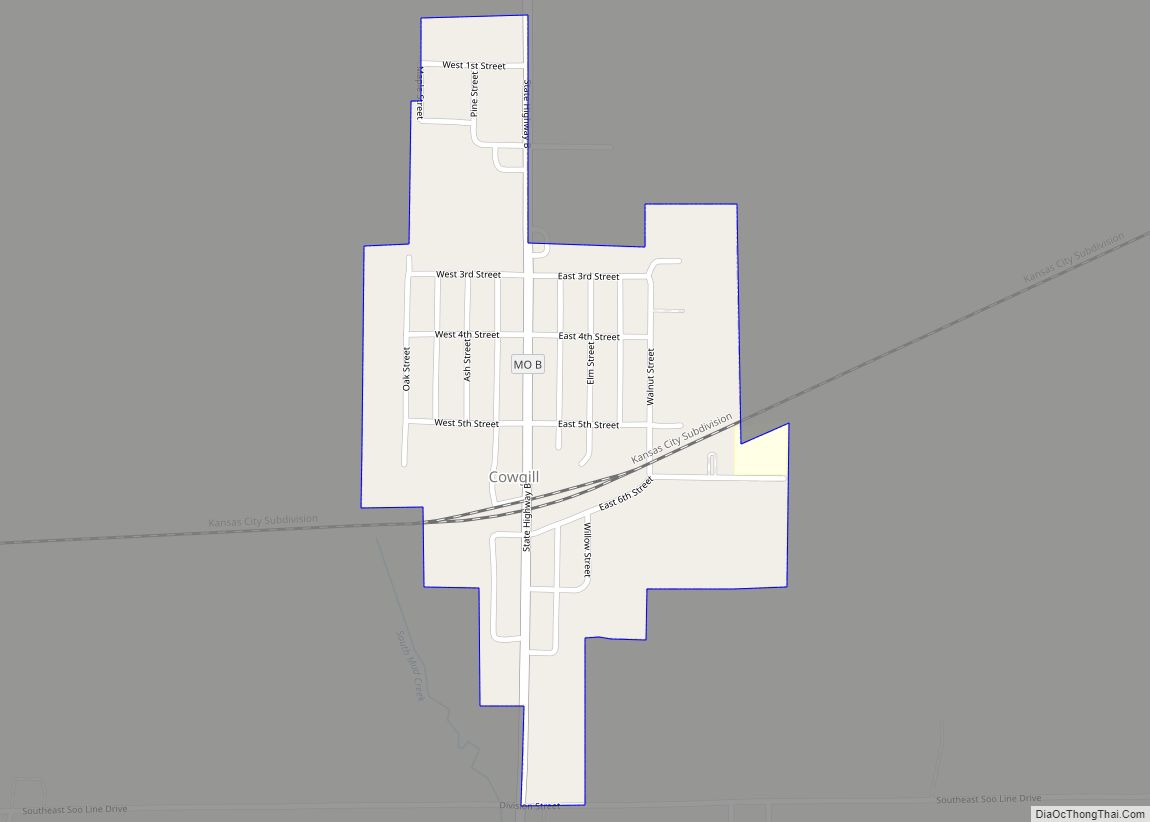
Cowgill is a city in southern Caldwell County, Missouri, and is part of the Kansas City metropolitan area with the United States. The population was 168 at the 2020 census. Cowgill city overview: Name: Cowgill city LSAD Code: 25 LSAD Description: city (suffix) State: Missouri County: Caldwell County Elevation: 974 ft (297 m) Total Area: 0.24 sq mi (0.62 km²) … Read more

Map of Country Life Acres village

Map of Country Life Acres village

Country Life Acres is a village in St. Louis County, Missouri, United States. The population was 74 at the 2010 census. Country Life Acres village overview: Name: Country Life Acres village LSAD Code: 47 LSAD Description: village (suffix) State: Missouri County: St. Louis County Elevation: 650 ft (200 m) Total Area: 0.12 sq mi (0.32 km²) Land Area: 0.12 sq mi (0.32 km²) … Read more

Map of Creighton city

Map of Creighton city, Missouri

Creighton is a city in Cass County, Missouri, United States. The population was 327 at the 2020 census. It is 57 miles south southeast of the Kansas City metropolitan area. Creighton city overview: Name: Creighton city LSAD Code: 25 LSAD Description: city (suffix) State: Missouri County: Cass County Elevation: 801 ft (244 m) Total Area: 0.34 sq mi (0.89 km²) … Read more

Map of Crane city, Missouri

Map of Crane city, Missouri

Crane (formerly Hickory Grove) is a town in Stone County, Missouri, United States. The population was 1,495 at the 2020 census. It is part of the Branson, Missouri Micropolitan Statistical Area. Crane city overview: Name: Crane city LSAD Code: 25 LSAD Description: city (suffix) State: Missouri County: Stone County Elevation: 1,145 ft (349 m) Total Area: 1.52 sq mi … Read more

Map of Crestwood city, Missouri

Map of Crestwood city, Missouri

Crestwood is a city in south St. Louis County, Missouri, United States, part of the Metropolitan Statistical Area known as Greater St. Louis. The population was 11,912 at the 2010 census. In 2011, Bloomberg Businessweek magazine named Crestwood the “Best Place to Raise Kids in Missouri,” lauding the community for top-tier schools and excellent municipal … Read more

Map of Cross Timbers city

Map of Cross Timbers city

Cross Timbers is a city in Hickory County, Missouri, United States. The population was 119 at the 2020 census. Cross Timbers city overview: Name: Cross Timbers city LSAD Code: 25 LSAD Description: city (suffix) State: Missouri County: Hickory County Elevation: 1,030 ft (310 m) Total Area: 0.45 sq mi (1.16 km²) Land Area: 0.45 sq mi (1.16 km²) Water Area: 0.00 sq mi (0.00 km²) Total … Read more

Map of Crocker city

Map of Crocker city, Missouri

Crocker is a city in Pulaski County, Missouri, United States. The population was 1,110 at the 2010 census. Crocker city overview: Name: Crocker city LSAD Code: 25 LSAD Description: city (suffix) State: Missouri County: Pulaski County Incorporated: 1872 Elevation: 1,083 ft (330 m) Total Area: 1.24 sq mi (3.22 km²) Land Area: 1.24 sq mi (3.22 km²) Water Area: 0.00 sq mi (0.00 km²) Total Population: … Read more

Map of Creve Coeur city, Missouri

Map of Creve Coeur city, Missouri

Creve Coeur /ˈkriːv ˈkɔːr/ is a city located in mid St. Louis County, Missouri, United States, a part of Greater St. Louis. Its population was 18,834 at the 2020 census. Creve Coeur borders and shares a ZIP code (63141) with the neighboring city of Town and Country. It is home to the headquarters of Drury … Read more

Map of Crystal Lakes city

Map of Crystal Lakes city, Missouri

Crystal Lakes is a city in western Ray County, Missouri, and part of the Kansas City metropolitan area within the United States. The population was 390 at the 2020 census. Crystal Lakes city overview: Name: Crystal Lakes city LSAD Code: 25 LSAD Description: city (suffix) State: Missouri County: Ray County Elevation: 856 ft (261 m) Total Area: … Read more

Map of Crystal Lake Park city

Map of Crystal Lake Park city

Crystal Lake Park is a Missouri Class 4 city in St. Louis County, Missouri, United States. The population was 508 at the 2020 census. Crystal Lake Park city overview: Name: Crystal Lake Park city LSAD Code: 25 LSAD Description: city (suffix) State: Missouri County: St. Louis County Elevation: 584 ft (178 m) Total Area: 0.10 sq mi (0.25 km²) Land … Read more

Map of Crystal City city

Map of Crystal City, Missouri

Crystal City is a city in eastern Jefferson County, Missouri, United States. The population was 4,855 at the 2010 census. It was 4,740 at the 2020 census. Crystal City and its neighbor Festus are often collectively known as the “Twin Cities”. Crystal City overview: Name: Crystal City LSAD Code: 25 LSAD Description: city (suffix) State: … Read more

Map of Dadeville village, Missouri

Map of Dadeville village, Missouri

Dadeville is a village in Dade County, Missouri, United States. The population was 226 at the 2020 census. Dadeville village overview: Name: Dadeville village LSAD Code: 47 LSAD Description: village (suffix) State: Missouri County: Dade County Elevation: 1,089 ft (332 m) Total Area: 0.99 sq mi (2.58 km²) Land Area: 0.99 sq mi (2.57 km²) Water Area: 0.00 sq mi (0.01 km²) Total Population: 226 Population … Read more