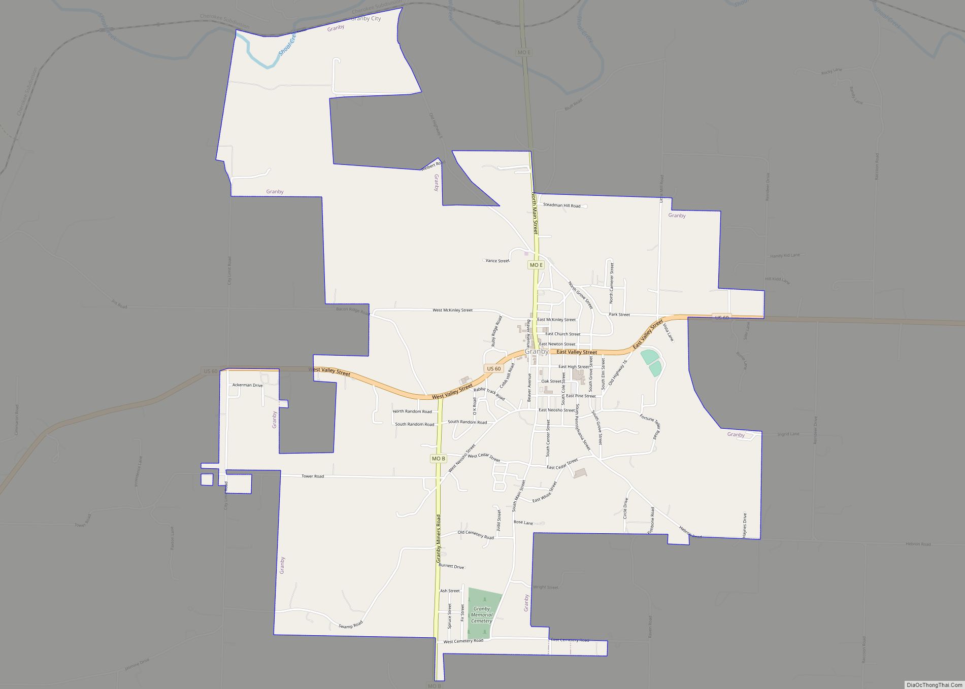
Map of Grand Pass village

Map of Grand Pass village

Grand Pass is a village in Saline County, Missouri, United States. The population was 66 at the 2010 census. Grand Pass village overview: Name: Grand Pass village LSAD Code: 47 LSAD Description: village (suffix) State: Missouri County: Saline County Elevation: 719 ft (219 m) Total Area: 0.11 sq mi (0.28 km²) Land Area: 0.11 sq mi (0.28 km²) Water Area: 0.00 sq mi (0.00 km²) Total … Read more

Map of Grand Falls Plaza town

Map of Grand Falls Plaza town

Grand Falls Plaza is a village in Newton County, Missouri, United States. The population was 114 at the 2010 census, at which time it was a town. It is part of the Joplin, Missouri Metropolitan Statistical Area. Grand Falls Plaza town overview: Name: Grand Falls Plaza town LSAD Code: 43 LSAD Description: town (suffix) State: … Read more

Map of Granger village, Missouri

Map of Granger village, Missouri

Granger is a village in Scotland County, Missouri, United States. As of the 2020 census, its population was 22. Granger village overview: Name: Granger village LSAD Code: 47 LSAD Description: village (suffix) State: Missouri County: Scotland County Elevation: 755 ft (230 m) Total Area: 0.16 sq mi (0.41 km²) Land Area: 0.16 sq mi (0.41 km²) Water Area: 0.00 sq mi (0.00 km²) Total Population: 22 … Read more

Map of Grandview city, Missouri

Map of Grandview city, Missouri

Grandview is a city in Jackson County, Missouri, United States. The population was 24,475 at the 2010 census. It is part of the Kansas City metropolitan area. Grandview city overview: Name: Grandview city LSAD Code: 25 LSAD Description: city (suffix) State: Missouri County: Jackson County Incorporated: February 6, 1912 Elevation: 1,050 ft (320 m) Total Area: 14.78 sq mi … Read more

Map of Grandin city

Map of Grandin city, Missouri

Grandin is a city in Carter County, Missouri, United States. The population was 226 at the 2020 census. Grandin city overview: Name: Grandin city LSAD Code: 25 LSAD Description: city (suffix) State: Missouri County: Carter County Elevation: 581 ft (177 m) Total Area: 0.40 sq mi (1.04 km²) Land Area: 0.40 sq mi (1.04 km²) Water Area: 0.00 sq mi (0.00 km²) Total Population: 226 Population … Read more

Map of Gravois Mills town

Map of Gravois Mills town

Gravois Mills is a town in Morgan County, Missouri, United States. The population was 144 at the 2010 census. Gravois Mills town overview: Name: Gravois Mills town LSAD Code: 43 LSAD Description: town (suffix) State: Missouri County: Morgan County Elevation: 755 ft (230 m) Total Area: 0.82 sq mi (2.13 km²) Land Area: 0.74 sq mi (1.92 km²) Water Area: 0.08 sq mi (0.21 km²) Total … Read more

Map of Grantwood Village town

Map of Grantwood Village town

Grantwood Village is a town in St. Louis County, Missouri, United States. The population was 863 at the 2010 census. Grantwood Village town overview: Name: Grantwood Village town LSAD Code: 43 LSAD Description: town (suffix) State: Missouri County: St. Louis County Elevation: 492 ft (150 m) Total Area: 0.83 sq mi (2.14 km²) Land Area: 0.82 sq mi (2.12 km²) Water Area: 0.01 sq mi … Read more

Map of Grant City town

Map of Grant City town

Grant City is a city in, and the county seat of, Worth County, Missouri, United States. The population was 859 at the 2010 census. Grant City town overview: Name: Grant City town LSAD Code: 43 LSAD Description: town (suffix) State: Missouri County: Worth County Elevation: 1,132 ft (345 m) Total Area: 1.33 sq mi (3.44 km²) Land Area: 1.33 sq mi (3.44 km²) … Read more

Map of Grayridge CDP

Map of Grayridge CDP

Grayridge is a census-designated place in eastern Stoddard County, Missouri, United States. It is located approximately ten miles southwest of Sikeston, just south of U.S. Route 60. A post office called Gray’s Ridge was established in 1879, the name was changed to Gray Ridge in 1887, and the present name of Grayridge was adopted in … Read more

Map of Grayhawk CDP

Map of Grayhawk CDP

Grayhawk is an unincorporated community and census-designated place in Ste. Genevieve County, Missouri, United States. Its population was 525 as of the 2010 census. Grayhawk CDP overview: Name: Grayhawk CDP LSAD Code: 57 LSAD Description: CDP (suffix) State: Missouri County: Ste. Genevieve County Elevation: 692 ft (211 m) Total Area: 4.70 sq mi (12.18 km²) Land Area: 4.35 sq mi (11.27 km²) Water … Read more

Map of Gray Summit CDP

Map of Gray Summit CDP

Gray Summit is an unincorporated community and census-designated place (CDP) in Franklin County, Missouri, United States. The population was 2,701 at the 2010 census. Also called “Gray’s Summit”, it was founded by Daniel Gray of New York, who built a hotel here in 1845. It is located on Missouri Route 100 just north of Interstate … Read more

Map of Green Ridge city

Map of Green Ridge city

Green Ridge is a city located along Route 127 in Pettis County, Missouri, United States. The population was 476 at the 2010 census. Green Ridge city overview: Name: Green Ridge city LSAD Code: 25 LSAD Description: city (suffix) State: Missouri County: Pettis County Elevation: 899 ft (274 m) Total Area: 0.43 sq mi (1.13 km²) Land Area: 0.43 sq mi (1.11 km²) Water … Read more