Map of Harviell CDP

Map of Harviell CDP

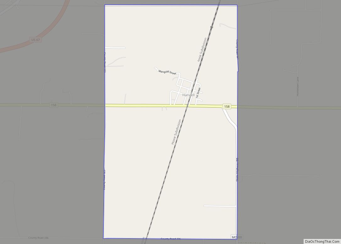
Harviell is an unincorporated community and census-designated place in Butler County, Missouri, United States. As of the 2020 census it had a population of 98. Harviell CDP overview: Name: Harviell CDP LSAD Code: 57 LSAD Description: CDP (suffix) State: Missouri County: Butler County Elevation: 315 ft (96 m) Total Area: 1.78 sq mi (4.60 km²) Land Area: 1.76 sq mi (4.57 km²) Water … Read more

Map of Hartwell CDP, Missouri

Map of Hartwell CDP, Missouri

Hartwell is a former village and census-designated place in Henry County, Missouri, United States. The population was 16 at the 2010 census. Hartwell CDP overview: Name: Hartwell CDP LSAD Code: 57 LSAD Description: CDP (suffix) State: Missouri County: Henry County Elevation: 758 ft (231 m) Total Area: 0.48 sq mi (1.23 km²) Land Area: 0.47 sq mi (1.23 km²) Water Area: 0.00 sq mi (0.00 km²) … Read more

Map of Hayti city

Map of Hayti city, Missouri

Hayti (pronounced “HAY-tie”) is a city in eastern Pemiscot County, Missouri, United States. The population was 2,493 at the 2020 census. Hayti city overview: Name: Hayti city LSAD Code: 25 LSAD Description: city (suffix) State: Missouri County: Pemiscot County Elevation: 269 ft (82 m) Total Area: 2.31 sq mi (5.98 km²) Land Area: 2.30 sq mi (5.95 km²) Water Area: 0.01 sq mi (0.03 km²) Total … Read more

Map of Hayti Heights city

Map of Hayti Heights city

Hayti Heights is a city in eastern Pemiscot County in the bootheel of southeast Missouri, United States. The population was 515 at the 2020 census. Hayti Heights city overview: Name: Hayti Heights city LSAD Code: 25 LSAD Description: city (suffix) State: Missouri County: Pemiscot County Elevation: 266 ft (81 m) Total Area: 0.98 sq mi (2.54 km²) Land Area: 0.98 sq mi … Read more

Map of Hawk Point city

Map of Hawk Point city

Hawk Point is a city in Lincoln County, Missouri, United States. The population was 669 at the 2010 census. Hawk Point city overview: Name: Hawk Point city LSAD Code: 25 LSAD Description: city (suffix) State: Missouri County: Lincoln County Elevation: 735 ft (224 m) Total Area: 0.42 sq mi (1.08 km²) Land Area: 0.41 sq mi (1.08 km²) Water Area: 0.00 sq mi (0.00 km²) Total … Read more

Map of Hazelwood city

Map of Hazelwood city

Hazelwood is a city in St. Louis County, Missouri, within Greater St. Louis. It is a second-ring northern suburb of St. Louis. Based on the 2020 United States census, the city had a total population of 25,485. It is located north of St. Louis-Lambert International Airport and is situated on Interstates 270 and 170, as … Read more

Map of Haywood City village

Map of Haywood City village

Haywood City is a village in Scott County, Missouri, United States. The population was 206 at the 2010 census. Haywood City village overview: Name: Haywood City village LSAD Code: 47 LSAD Description: village (suffix) State: Missouri County: Scott County Elevation: 351 ft (107 m) Total Area: 0.43 sq mi (1.11 km²) Land Area: 0.43 sq mi (1.11 km²) Water Area: 0.00 sq mi (0.00 km²) Total … Read more

Map of Hayward CDP, Missouri

Map of Hayward CDP, Missouri

Hayward is a census-designated place and former village in Pemiscot County, Missouri, United States. The population was 131 at the 2010 census. Hayward CDP overview: Name: Hayward CDP LSAD Code: 57 LSAD Description: CDP (suffix) State: Missouri County: Pemiscot County Elevation: 282 ft (86 m) Total Area: 0.25 sq mi (0.66 km²) Land Area: 0.25 sq mi (0.66 km²) Water Area: 0.00 sq mi (0.00 km²) … Read more

Map of Hermann city

Map of Hermann city

Hermann is a city in and the county seat of Gasconade County, Missouri, United States. It has been the county seat since 1842. It is near the center of the Missouri Rhineland and south of the Missouri River. The population was 2,185 at the 2020 census. The city is the commercial center of the Hermann … Read more

Map of Herculaneum city

Map of Herculaneum city

Herculaneum is a city in Jefferson County, Missouri, United States, and is a suburb of St. Louis. The population was 4,273 at the 2020 United States Census. The City of Herculaneum was the first county seat of Jefferson County from January 1, 1819 to 1839. The city celebrated its bicentennial throughout 2008. The city received … Read more

Map of Henrietta city

Map of Henrietta city, Missouri

Henrietta is a city in southern Ray County, Missouri, and part of the Kansas City metropolitan area within the United States. The population was 278 at the 2020 census. Henrietta city overview: Name: Henrietta city LSAD Code: 25 LSAD Description: city (suffix) State: Missouri County: Ray County Elevation: 705 ft (215 m) Total Area: 0.60 sq mi (1.54 km²) Land … Read more

Map of Higbee city

Map of Higbee city

Higbee is a city in southern Randolph County, Missouri, United States. The population was 568 at the 2010 census. Barrel-making company A&K Cooperage, Barrel 53 Cooperage and Woodsmen Distilling are based in Higbee. Higbee city overview: Name: Higbee city LSAD Code: 25 LSAD Description: city (suffix) State: Missouri County: Randolph County Elevation: 879 ft (268 m) Total … Read more