Map of Iberia city

Map of Iberia city, Missouri

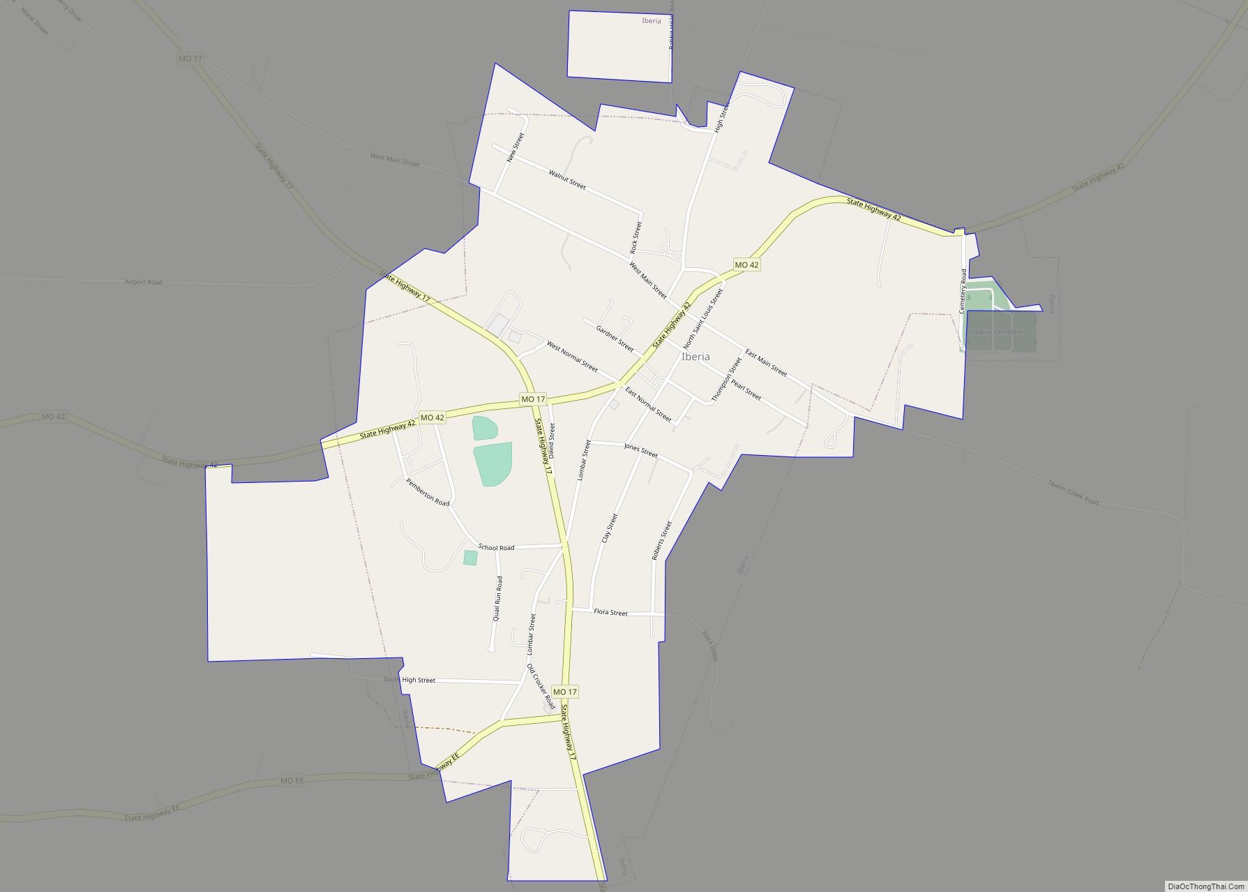
Iberia is a city in southeast Miller County, Missouri, United States. The population was 736 at the 2010 census. Iberia city overview: Name: Iberia city LSAD Code: 25 LSAD Description: city (suffix) State: Missouri County: Miller County Founded: 1860 Elevation: 938 ft (286 m) Total Area: 0.88 sq mi (2.28 km²) Land Area: 0.88 sq mi (2.28 km²) Water Area: 0.00 sq mi (0.00 km²) Total … Read more

Map of Iatan village

Map of Iatan village

Iatan is a village in Platte County, Missouri within the United States. The population was 69 at the 2010 census. It is within the Kansas City metropolitan area. Iatan village overview: Name: Iatan village LSAD Code: 47 LSAD Description: village (suffix) State: Missouri County: Platte County Elevation: 922 ft (281 m) Total Area: 0.22 sq mi (0.56 km²) Land Area: … Read more

Map of Ionia town, Missouri

Map of Ionia town, Missouri

Ionia is a village in northern Benton and southern Pettis counties in the U.S. state of Missouri. The population was 88 at the 2010 census. Ionia town overview: Name: Ionia town LSAD Code: 43 LSAD Description: town (suffix) State: Missouri County: Benton County, Pettis County Elevation: 958 ft (292 m) Total Area: 0.15 sq mi (0.38 km²) Land Area: 0.15 sq mi … Read more

Map of Innsbrook village

Map of Innsbrook village, Missouri

Innsbrook is a village in Warren County, Missouri, United States. The population was 552 at the 2010 census. The village of Innsbrook is comprised almost entirely by Innsbrook Resort—a private, gated community. The village was founded in 1998. Innsbrook village overview: Name: Innsbrook village LSAD Code: 47 LSAD Description: village (suffix) State: Missouri County: Warren … Read more

Map of Indian Point village

Map of Indian Point village

Indian Point is a village in Stone County, Missouri, United States. The population was 550 at the 2020 census. It is part of the Branson, Missouri Micropolitan Statistical Area. Indian Point village overview: Name: Indian Point village LSAD Code: 47 LSAD Description: village (suffix) State: Missouri County: Stone County Elevation: 974 ft (297 m) Total Area: 3.90 sq mi … Read more

Map of Irondale city, Missouri

Map of Irondale city, Missouri

Irondale is a city in Washington County, Missouri, United States. The population was 445 at the 2010 census. Irondale city overview: Name: Irondale city LSAD Code: 25 LSAD Description: city (suffix) State: Missouri County: Washington County Elevation: 906 ft (276 m) Total Area: 0.54 sq mi (1.40 km²) Land Area: 0.53 sq mi (1.38 km²) Water Area: 0.01 sq mi (0.02 km²) Total Population: 368 Population … Read more

Map of Iron Mountain Lake city

Map of Iron Mountain Lake city

Iron Mountain Lake is a city in St. Francois County, Missouri, United States. The population was 737 at the 2010 census. Iron Mountain Lake city overview: Name: Iron Mountain Lake city LSAD Code: 25 LSAD Description: city (suffix) State: Missouri County: St. Francois County Elevation: 1,053 ft (321 m) Total Area: 2.09 sq mi (5.40 km²) Land Area: 1.96 sq mi (5.08 km²) … Read more

Map of Irena village

Map of Irena village

Irena is a village in north central Worth County, Missouri, United States. The population was 14 at the 2020 census. Irena village overview: Name: Irena village LSAD Code: 47 LSAD Description: village (suffix) State: Missouri County: Worth County Elevation: 1,132 ft (345 m) Total Area: 0.88 sq mi (2.28 km²) Land Area: 0.88 sq mi (2.28 km²) Water Area: 0.00 sq mi (0.00 km²) Total Population: … Read more

Map of Jackson city, Missouri

Map of Jackson city, Missouri

Jackson is a city in and the county seat of Cape Girardeau County, Missouri, United States. It is a principal city of the Cape Girardeau–Jackson, MO-IL Metropolitan Statistical Area. The population of Jackson was 15,481 at the 2020 census. Jackson city overview: Name: Jackson city LSAD Code: 25 LSAD Description: city (suffix) State: Missouri County: … Read more

Map of Irwin CDP, Missouri

Map of Irwin CDP, Missouri

Irwin is an unincorporated community and census-designated place in northern Barton County, Missouri, United States. As of the 2020 census it had a population of 47. Irwin CDP overview: Name: Irwin CDP LSAD Code: 57 LSAD Description: CDP (suffix) State: Missouri County: Barton County Elevation: 968 ft (295 m) Total Area: 0.30 sq mi (0.78 km²) Land Area: 0.30 sq mi (0.77 km²) … Read more

Map of Ironton city, Missouri

Map of Ironton city, Missouri

Ironton is a city in Iron County, Missouri, United States. The population was 1,475 at the 2020 census. It is the county seat of Iron County, and is located 12 miles south of Belgrade. Ironton city overview: Name: Ironton city LSAD Code: 25 LSAD Description: city (suffix) State: Missouri County: Iron County Elevation: 938 ft (286 m) … Read more

Map of Jacksonville village, Missouri

Map of Jacksonville village, Missouri

Jacksonville is a village in Randolph County, Missouri, United States. The population was 151 at the 2010 census. Jacksonville village overview: Name: Jacksonville village LSAD Code: 47 LSAD Description: village (suffix) State: Missouri County: Randolph County Elevation: 863 ft (263 m) Total Area: 0.11 sq mi (0.29 km²) Land Area: 0.11 sq mi (0.29 km²) Water Area: 0.00 sq mi (0.00 km²) Total Population: 122 Population … Read more