Map of Lathrop city, Missouri

Map of Lathrop city, Missouri

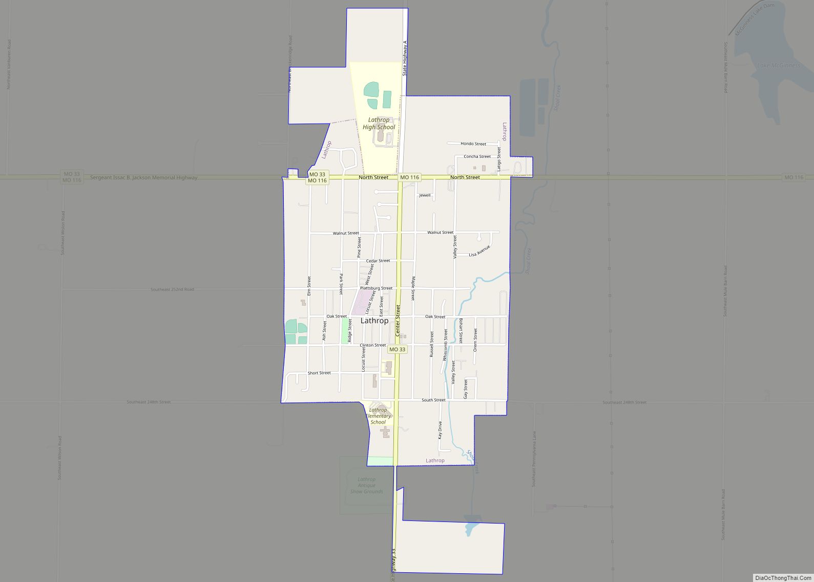
Lathrop is a city in Clinton County, Missouri, and is part of the Kansas City metropolitan area within the United States. The population was 2,086 at the 2010 census. Lathrop city overview: Name: Lathrop city LSAD Code: 25 LSAD Description: city (suffix) State: Missouri County: Clinton County Elevation: 1,043 ft (318 m) Total Area: 4.19 sq mi (10.86 km²) Land … Read more

Map of Laredo city

Map of Laredo city, Missouri

Laredo is a city in Grundy County, Missouri, United States. The population was 156 at the 2020 census. Laredo is pronounced “la-read-oh” which varies from the traditional pronunciation. Laredo city overview: Name: Laredo city LSAD Code: 25 LSAD Description: city (suffix) State: Missouri County: Grundy County Elevation: 814 ft (248 m) Total Area: 0.28 sq mi (0.71 km²) Land Area: … Read more

Map of Leadwood city

Map of Leadwood city

Leadwood is a city in St. Francois County, Missouri, United States. The population was 1,282 at the 2010 census. Leadwood city overview: Name: Leadwood city LSAD Code: 25 LSAD Description: city (suffix) State: Missouri County: St. Francois County Incorporated: 1964 Elevation: 758 ft (231 m) Total Area: 1.16 sq mi (3.00 km²) Land Area: 1.16 sq mi (3.00 km²) Water Area: 0.00 sq mi (0.00 km²) … Read more

Map of Leadington city

Map of Leadington city

Leadington is a city in St. Francois County, Missouri, United States. The population was 422 at the 2010 census. Leadington city overview: Name: Leadington city LSAD Code: 25 LSAD Description: city (suffix) State: Missouri County: St. Francois County Elevation: 896 ft (273 m) Total Area: 0.91 sq mi (2.36 km²) Land Area: 0.91 sq mi (2.36 km²) Water Area: 0.00 sq mi (0.00 km²) Total Population: … Read more

Map of Lawson city

Map of Lawson city

Lawson is a city in Clay, Clinton, and Ray counties in the U.S. state of Missouri and part of the Kansas City metropolitan area. The population was 2,541 at the 2020 census. Lawson city overview: Name: Lawson city LSAD Code: 25 LSAD Description: city (suffix) State: Missouri County: Clay County, Ray County Elevation: 1,034 ft (315 m) … Read more

Map of Lebanon city, Missouri

Map of Lebanon city, Missouri

Lebanon is a city in and the county seat of Laclede County in Missouri. The population was 14,474 at the time of the 2010 census. It is the county seat of Laclede County. The Lebanon Micropolitan Statistical Area consists of Laclede County. Lebanon city overview: Name: Lebanon city LSAD Code: 25 LSAD Description: city (suffix) … Read more

Map of Leawood village, Missouri

Map of Leawood village, Missouri

Leawood is a village in Newton County, Missouri, United States. The population was 682 at the 2010 census. It is part of the Joplin, Missouri Metropolitan Statistical Area. Leawood village overview: Name: Leawood village LSAD Code: 47 LSAD Description: village (suffix) State: Missouri County: Newton County Elevation: 984 ft (300 m) Total Area: 1.24 sq mi (3.22 km²) Land Area: … Read more

Map of Leasburg village

Map of Leasburg village

Leasburg is a village in Crawford County, Missouri, United States. The population was 338 at the 2010 census. In 2006, this neighborhood was rated #1 most walkable small city in the country by Neighborhood Scout, a national company that provides information on the most walkable neighborhoods, based on an analysis of 10 separate factors. Leasburg … Read more

Map of Leisure Lake CDP

Map of Leisure Lake CDP

Leisure Lake is an unincorporated community and census-designated place (CDP) in Grundy County, Missouri, United States. As of the 2020 census, the population was 166. It is located in western Grundy County and consists of a residential community set round a reservoir named Leisure Lake. Missouri Route 146 forms the eastern and northern edge of … Read more

Map of Leeton city

Map of Leeton city

Leeton is a city in southeast Johnson County, Missouri, United States. The population was 566 at the 2010 census. Leeton city overview: Name: Leeton city LSAD Code: 25 LSAD Description: city (suffix) State: Missouri County: Johnson County Elevation: 948 ft (289 m) Total Area: 0.52 sq mi (1.34 km²) Land Area: 0.52 sq mi (1.34 km²) Water Area: 0.00 sq mi (0.00 km²) Total Population: 532 … Read more

Map of Lee's Summit city

Map of Lee’s Summit city

Lee’s Summit is a city in the U.S. state of Missouri and is a suburb in the Kansas City metropolitan area. It primarily resides in Jackson county, but also resides in Cass county. As of the 2020 census, its population was 101,108, making it the sixth-largest city in both Missouri and the Kansas City metropolitan … Read more

Map of Leslie village, Missouri

Map of Leslie village, Missouri

Leslie is a village in west central Franklin County, Missouri, United States. The population was 171 at the 2010 census. Leslie village overview: Name: Leslie village LSAD Code: 47 LSAD Description: village (suffix) State: Missouri County: Franklin County Elevation: 827 ft (252 m) Total Area: 0.17 sq mi (0.44 km²) Land Area: 0.17 sq mi (0.44 km²) Water Area: 0.00 sq mi (0.00 km²) Total Population: … Read more