Map of Linn city, Missouri

Map of Linn city, Missouri

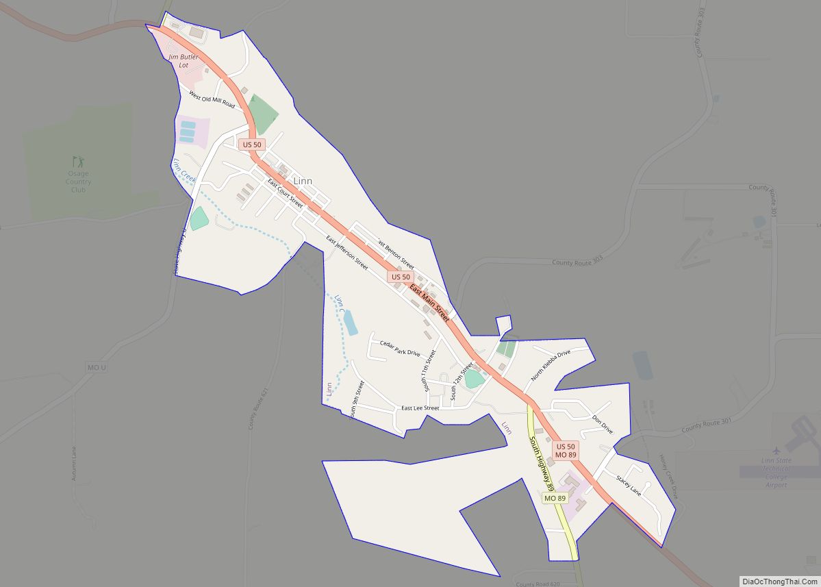
Linn is a city in Osage County, Missouri, United States. The population was 1,350 at the 2020 census. It is the county seat of Osage County. Linn is part of the Jefferson City, Missouri Metropolitan Statistical Area. Linn city overview: Name: Linn city LSAD Code: 25 LSAD Description: city (suffix) State: Missouri County: Osage County … Read more

Map of Linn Creek city

Map of Linn Creek city

Linn Creek is a city in Camden County, Missouri, United States. The population was 216 at the 2020 census. The original Linn Creek, which was the original county seat of Camden County, Missouri, is now under water, in the Lake of the Ozarks. Construction of the Bagnell Dam that created the lake was begun August … Read more

Map of Loch Lloyd village

Map of Loch Lloyd village

Loch Lloyd village overview: Name: Loch Lloyd village LSAD Code: 47 LSAD Description: village (suffix) State: Missouri County: Cass County FIPS code: 2943468 Online Interactive Map Loch Lloyd online map. Source: Basemap layers from Google Map, Open Street Map (OSM), Arcgisonline, Wmflabs. Boundary Data from Database of Global Administrative Areas. Loch Lloyd location map. Where … Read more

Map of Livonia village, Missouri

Map of Livonia village, Missouri

Livonia is a village in eastern Putnam County, Missouri, United States. The population was 52 at the 2020 census. Livonia village overview: Name: Livonia village LSAD Code: 47 LSAD Description: village (suffix) State: Missouri County: Putnam County Elevation: 830 ft (250 m) Total Area: 0.27 sq mi (0.69 km²) Land Area: 0.27 sq mi (0.69 km²) Water Area: 0.00 sq mi (0.00 km²) Total Population: 52 … Read more

Map of Lithium CDP

Map of Lithium CDP

Lithium is a census-designated place and former village located in Perry County, Missouri, United States. The population was 92 at the 2020 census. The 2000 Census found Lithium to have zero residents; an Associated Press article, however, stated that about 50 people in fact resided there, but may have been counted as part of Perry … Read more

Map of Lohman city

Map of Lohman city

Lohman is a city in Cole County, Missouri, United States. The population was 175 at the 2020 census. It is part of the Jefferson City, Missouri Metropolitan Statistical Area. Lohman city overview: Name: Lohman city LSAD Code: 25 LSAD Description: city (suffix) State: Missouri County: Cole County Incorporated: 1882 Elevation: 676 ft (206 m) Total Area: 0.36 sq mi … Read more

Map of Lockwood city, Missouri

Map of Lockwood city, Missouri

Lockwood is a city in Dade County, Missouri, United States. The population was 846 at the 2020 census. Lockwood city overview: Name: Lockwood city LSAD Code: 25 LSAD Description: city (suffix) State: Missouri County: Dade County Elevation: 1,083 ft (330 m) Total Area: 0.99 sq mi (2.55 km²) Land Area: 0.97 sq mi (2.51 km²) Water Area: 0.02 sq mi (0.04 km²) Total Population: 846 Population … Read more

Map of Lock Springs village

Map of Lock Springs village

Lock Springs is a village in southeast Daviess County, Missouri, United States. The population was 40 at the 2020 census. Lock Springs village overview: Name: Lock Springs village LSAD Code: 47 LSAD Description: village (suffix) State: Missouri County: Daviess County Elevation: 735 ft (224 m) Total Area: 0.12 sq mi (0.32 km²) Land Area: 0.12 sq mi (0.32 km²) Water Area: 0.00 sq mi (0.00 km²) … Read more

Map of Loma Linda town, Missouri

Map of Loma Linda town, Missouri

Loma Linda is a town in Newton County, Missouri, United States. The population was 725 at the 2010 census. It is part of the Joplin, Missouri Metropolitan Statistical Area. Loma Linda town overview: Name: Loma Linda town LSAD Code: 43 LSAD Description: town (suffix) State: Missouri County: Newton County Elevation: 1,070 ft (330 m) Total Area: 3.56 sq mi … Read more

Map of Longtown town

Map of Longtown town, Missouri

Longtown is a village in Union Township in Perry County, Missouri, United States. The population was 90 at the 2020 census. Longtown town overview: Name: Longtown town LSAD Code: 43 LSAD Description: town (suffix) State: Missouri County: Perry County Elevation: 656 ft (200 m) Total Area: 0.13 sq mi (0.32 km²) Land Area: 0.13 sq mi (0.32 km²) Water Area: 0.00 sq mi (0.00 km²) Total … Read more

Map of Lone Jack city

Map of Lone Jack city

Lone Jack is a city in Jackson County, Missouri, United States. The population was 1,492 at the 2020 U.S. Census. It is part of the Kansas City metropolitan area. Lone Jack city overview: Name: Lone Jack city LSAD Code: 25 LSAD Description: city (suffix) State: Missouri County: Jackson County Elevation: 1,017 ft (310 m) Total Area: 5.92 sq mi … Read more

Map of Lowry City city

Map of Lowry City

Lowry City is a city in St. Clair County, Missouri, United States. The population was 613 at the 2020 census. Lowry City is the city where the Ozark Mountains meet the Great Plains. Lowry City overview: Name: Lowry City LSAD Code: 25 LSAD Description: city (suffix) State: Missouri County: St. Clair County Elevation: 876 ft (267 m) … Read more