Map of Rayville CDP, Missouri

Map of Rayville CDP, Missouri

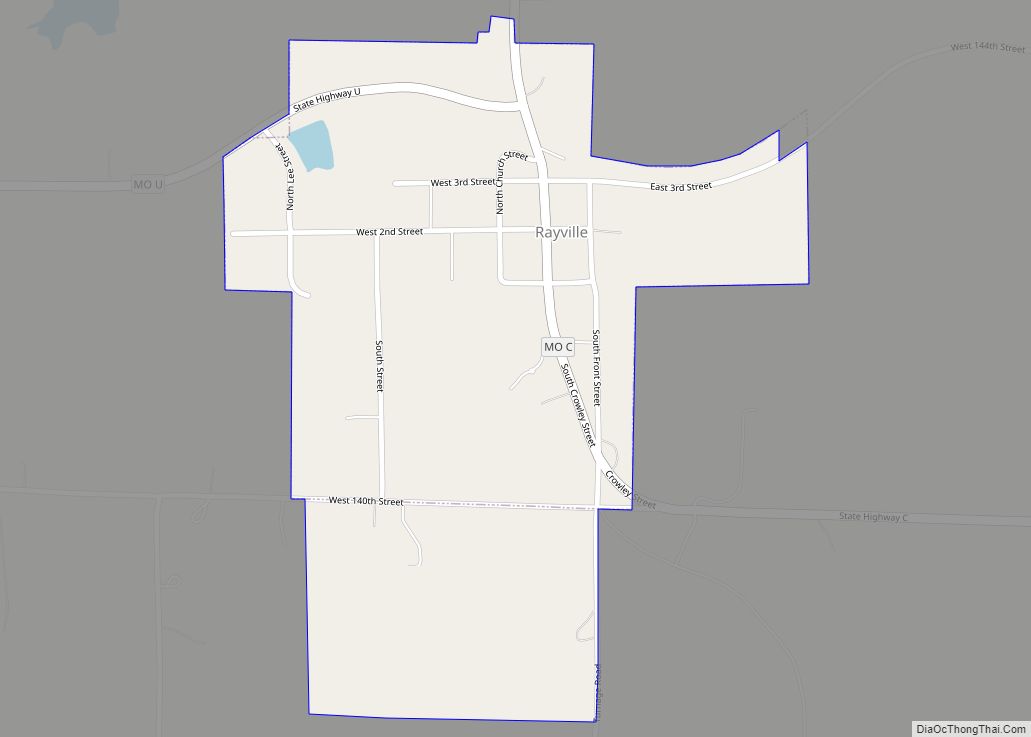
Rayville is a census-designated place and former village in Ray County, Missouri, and part of the Kansas City metropolitan area within the United States. The population was 157 at the 2020 census. It disincorporated in 2012. Rayville CDP overview: Name: Rayville CDP LSAD Code: 57 LSAD Description: CDP (suffix) State: Missouri County: Ray County Elevation: … Read more

Map of Raytown city

Map of Raytown city

Raytown is a city in Jackson County, Missouri, United States, and is a suburb of Kansas City. The population was at 30,012 in 2020 census. The mayor of Raytown is Michael McDonough and the mayor pro tem is Ryan Myers. It is part of the Kansas City metropolitan area. Raytown city overview: Name: Raytown city … Read more

Map of Reeds town

Map of Reeds town

Reeds is a village in Jasper County, Missouri, United States. The population was 91 at the 2020 census. It is part of the Joplin, Missouri Metropolitan Statistical Area. For a short time, it was the county seat of Jasper County. Reeds town overview: Name: Reeds town LSAD Code: 43 LSAD Description: town (suffix) State: Missouri … Read more

Map of Reeds Spring city

Map of Reeds Spring city

Reeds Spring is a city in Stone County, Missouri, United States. The population was 1,136 at the 2020 census. It is part of the Branson, Missouri Micropolitan Statistical Area. Reeds Spring city overview: Name: Reeds Spring city LSAD Code: 25 LSAD Description: city (suffix) State: Missouri County: Stone County Elevation: 1,181 ft (360 m) Total Area: 1.50 sq mi … Read more

Map of Redings Mill village

Map of Redings Mill village

Redings Mill is a village in Newton County, Missouri, United States. The population was 151 at the 2010 census. It is part of the Joplin, Missouri Metropolitan Statistical Area. Redings Mill village overview: Name: Redings Mill village LSAD Code: 47 LSAD Description: village (suffix) State: Missouri County: Newton County Total Area: 0.21 sq mi (0.54 km²) Land Area: … Read more

Map of Republic city, Missouri

Map of Republic city, Missouri

Republic is a city in Christian and Greene counties in the U.S. state of Missouri. As of the 2020 census, the city’s population was 18,750. In 2019, its population was 16,938, making it the second largest city in Greene County in the U.S. state of Missouri. It is part of the Springfield, Missouri, Metropolitan Statistical … Read more

Map of Rensselaer village, Missouri

Map of Rensselaer village, Missouri

Rensselaer is a village in Ralls County, Missouri, United States. The population was 253 at the 2020 census. It is part of the Hannibal Micropolitan Statistical Area. Rensselaer village overview: Name: Rensselaer village LSAD Code: 47 LSAD Description: village (suffix) State: Missouri County: Ralls County Elevation: 692 ft (211 m) Total Area: 2.01 sq mi (5.20 km²) Land Area: 1.96 sq mi … Read more

Map of Renick village

Map of Renick village

Renick is a village in Randolph County, Missouri, United States. The population was 172 at the 2010 census. Renick village overview: Name: Renick village LSAD Code: 47 LSAD Description: village (suffix) State: Missouri County: Randolph County Elevation: 873 ft (266 m) Total Area: 0.36 sq mi (0.93 km²) Land Area: 0.36 sq mi (0.93 km²) Water Area: 0.00 sq mi (0.00 km²) Total Population: 154 Population … Read more

Map of Rich Hill city

Map of Rich Hill city

Rich Hill is a city in southern Bates County, Missouri, and is part of the Kansas City metropolitan area within the United States. The population was 1,232 at the 2020 census. Rich Hill city overview: Name: Rich Hill city LSAD Code: 25 LSAD Description: city (suffix) State: Missouri County: Bates County Elevation: 804 ft (245 m) Total … Read more

Map of Rhineland town

Map of Rhineland town

Rhineland is a village in Montgomery County, Missouri, United States. The population was 139 at the 2020 census. Its name came from German immigrants from the river Rhine area. Located on the north bank of the Missouri River, Rhineland was devastated in the Great Flood of 1993. It was one of the first towns to … Read more

Map of Revere town, Missouri

Map of Revere town, Missouri

Revere is a city in Clark County, Missouri, United States. As of the 2020 census, its population was 76. It is part of the Fort Madison–Keokuk, IA-MO Micropolitan Statistical Area. Revere town overview: Name: Revere town LSAD Code: 43 LSAD Description: town (suffix) State: Missouri County: Clark County Elevation: 682 ft (208 m) Total Area: 0.19 sq mi (0.48 km²) … Read more

Map of Richmond Heights city, Missouri

Map of Richmond Heights city, Missouri

Richmond Heights is a city in St. Louis County, Missouri. It is an inner-ring suburb of St. Louis, Missouri, United States. The population was 8,603 at the 2010 census. According to Robert L. Ramsay, the name was suggested by Robert E. Lee, who thought the topography of the area resembled Richmond, Virginia. Richmond Heights city … Read more