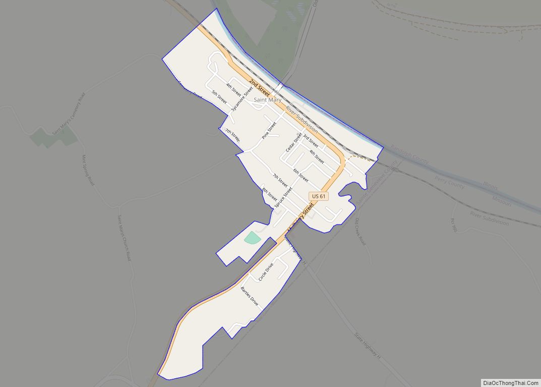
Map of St. Paul city, Missouri

Map of St. Paul city, Missouri

St. Paul is a city in St. Charles County, Missouri, United States. The population was 1,829 at the 2010 census. St. Paul city overview: Name: St. Paul city LSAD Code: 25 LSAD Description: city (suffix) State: Missouri County: St. Charles County Elevation: 515 ft (157 m) Total Area: 7.19 sq mi (18.62 km²) Land Area: 7.19 sq mi (18.62 km²) Water Area: 0.00 sq mi … Read more

Map of Steelville city

Map of Steelville city

Steelville is a city in Crawford County, Missouri, United States. The population was 1,472 at the 2020 census. It is the county seat of Crawford County. Steelville is the hometown of Congressman Albert Reeves and Missouri State Representative Jason Chipman. The town was named after the landowner James Steel. Steelville city overview: Name: Steelville city … Read more

Map of Steele city, Missouri

Map of Steele city, Missouri

Steele is a city in southern Pemiscot County in the Missouri Bootheel of southeastern Missouri, United States. The population was 1,853 at the 2020 census. Steele city overview: Name: Steele city LSAD Code: 25 LSAD Description: city (suffix) State: Missouri County: Pemiscot County Elevation: 259 ft (79 m) Total Area: 2.19 sq mi (5.67 km²) Land Area: 2.16 sq mi (5.60 km²) Water … Read more

Map of Ste. Genevieve city

Map of Ste. Genevieve city

Ste. Genevieve city overview: Name: Ste. Genevieve city LSAD Code: 25 LSAD Description: city (suffix) State: Missouri County: Ste. Genevieve County FIPS code: 2964180 Online Interactive Map Ste. Genevieve online map. Source: Basemap layers from Google Map, Open Street Map (OSM), Arcgisonline, Wmflabs. Boundary Data from Database of Global Administrative Areas. Ste. Genevieve location map. … Read more

Map of Stark City town

Map of Stark City town

Stark City is a town in Newton County, Missouri, United States. The population was 139 at the 2010 census, at which time it was a town. It is part of the Joplin, Missouri Metropolitan Statistical Area. It is adjacent to the battlefield of the Second Battle of Newtonia. Stark City town overview: Name: Stark City … Read more

Map of Stanberry city

Map of Stanberry city

Stanberry is a city in Gentry County, Missouri, United States. The population was 1,129 at the 2020 census. Stanberry city overview: Name: Stanberry city LSAD Code: 25 LSAD Description: city (suffix) State: Missouri County: Gentry County Elevation: 948 ft (289 m) Total Area: 1.40 sq mi (3.63 km²) Land Area: 1.40 sq mi (3.63 km²) Water Area: 0.00 sq mi (0.00 km²) Total Population: 1,129 Population … Read more

Map of Stotts City city

Map of Stotts City

Stotts City is a city in Lawrence County, Missouri, United States. The population was 220 at the 2010 census. It was estimated to be 217 by the City of Stotts City as of July 1, 2019. Stotts City overview: Name: Stotts City LSAD Code: 25 LSAD Description: city (suffix) State: Missouri County: Lawrence County Elevation: … Read more

Map of Stotesbury town

Map of Stotesbury town

Stotesbury is a village in northwest Vernon County, Missouri, United States. The population was 18 at the 2010 census. Stotesbury town overview: Name: Stotesbury town LSAD Code: 43 LSAD Description: town (suffix) State: Missouri County: Vernon County Elevation: 791 ft (241 m) Total Area: 0.11 sq mi (0.29 km²) Land Area: 0.11 sq mi (0.29 km²) Water Area: 0.00 sq mi (0.00 km²) Total Population: 12 … Read more

Map of Stockton city, Missouri

Map of Stockton city, Missouri

Stockton is a city in Cedar County, Missouri, United States. The population was 1,683 at the 2020 census. It is the county seat of Cedar County. Stockton city overview: Name: Stockton city LSAD Code: 25 LSAD Description: city (suffix) State: Missouri County: Cedar County Elevation: 974 ft (297 m) Total Area: 2.16 sq mi (5.58 km²) Land Area: 2.12 sq mi (5.48 km²) … Read more

Map of Stewartsville city

Map of Stewartsville city, Missouri

Stewartsville is a city in southwest DeKalb County, Missouri, United States. The population was 733 at the 2020 census. The community is named for Robert M. Stewart, a former Missouri governor. It is part of the St. Joseph, MO–KS Metropolitan Statistical Area. Stewartsville city overview: Name: Stewartsville city LSAD Code: 25 LSAD Description: city (suffix) … Read more

Map of Stella town

Map of Stella town, Missouri

Stella is a village in southern Newton County, Missouri, United States. The population was 158 at the 2010 census. It is part of the Joplin, Missouri Metropolitan Statistical Area. The village of Stella is located 17 miles southeast of Neosho. Stella town overview: Name: Stella town LSAD Code: 43 LSAD Description: town (suffix) State: Missouri … Read more

Map of Stoutsville village

Map of Stoutsville village, Missouri

Stoutsville is a village in Monroe County, Missouri, United States. The population was 37 at the 2020 census. Stoutsville village overview: Name: Stoutsville village LSAD Code: 47 LSAD Description: village (suffix) State: Missouri County: Monroe County Elevation: 610 ft (190 m) Total Area: 0.83 sq mi (2.16 km²) Land Area: 0.82 sq mi (2.13 km²) Water Area: 0.01 sq mi (0.02 km²) Total Population: 37 Population … Read more