Map of Strafford city

Map of Strafford city

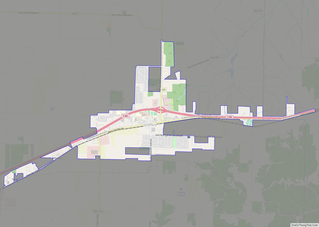
Strafford is a city in eastern Greene County, Missouri, United States. It is part of the Springfield, Missouri Metropolitan Statistical Area. The city’s population was 2,561 at the 2020 census. Strafford city overview: Name: Strafford city LSAD Code: 25 LSAD Description: city (suffix) State: Missouri County: Greene County Elevation: 1,490 ft (454 m) Total Area: 300.29 sq mi (8.52 km²) … Read more

Map of Stover city

Map of Stover city

Stover is a city in Morgan County, Missouri, United States. The population was 1,094 at the 2010 census. Stover city overview: Name: Stover city LSAD Code: 25 LSAD Description: city (suffix) State: Missouri County: Morgan County Elevation: 1,086 ft (331 m) Total Area: 0.89 sq mi (2.30 km²) Land Area: 0.89 sq mi (2.30 km²) Water Area: 0.00 sq mi (0.00 km²) Total Population: 1,006 Population … Read more

Map of Stoutsville village

Map of Stoutsville village, Missouri

Stoutsville is a village in Monroe County, Missouri, United States. The population was 37 at the 2020 census. Stoutsville village overview: Name: Stoutsville village LSAD Code: 47 LSAD Description: village (suffix) State: Missouri County: Monroe County Elevation: 610 ft (190 m) Total Area: 0.83 sq mi (2.16 km²) Land Area: 0.82 sq mi (2.13 km²) Water Area: 0.01 sq mi (0.02 km²) Total Population: 37 Population … Read more

Map of Stoutland city

Map of Stoutland city

Stoutland is a city in Camden and Laclede counties in the U.S. state of Missouri. The population was 192 at the 2010 census. Stoutland city overview: Name: Stoutland city LSAD Code: 25 LSAD Description: city (suffix) State: Missouri County: Camden County, Laclede County Elevation: 1,171 ft (357 m) Total Area: 0.60 sq mi (1.57 km²) Land Area: 0.60 sq mi (1.57 km²) Water … Read more

Map of Sumner town, Missouri

Map of Sumner town, Missouri

Sumner is a city in Chariton County, Missouri, United States. The population was 78 at the 2020 census. It was named in honor of U.S. Senator Charles Sumner. Sumner town overview: Name: Sumner town LSAD Code: 43 LSAD Description: town (suffix) State: Missouri County: Chariton County Elevation: 679 ft (207 m) Total Area: 0.23 sq mi (0.59 km²) Land Area: … Read more

Map of Summersville city, Missouri

Map of Summersville city, Missouri

Summersville is a city in Shannon and Texas counties in the U.S. state of Missouri. The population was 453 at the 2020 census. Summersville city overview: Name: Summersville city LSAD Code: 25 LSAD Description: city (suffix) State: Missouri County: Shannon County, Texas County Elevation: 1,234 ft (376 m) Total Area: 1.11 sq mi (2.87 km²) Land Area: 1.11 sq mi (2.87 km²) Water … Read more

Map of Sullivan city, Missouri

Map of Sullivan city, Missouri

Sullivan is a city that straddles the border of Franklin and Crawford counties in the U.S. state of Missouri. The population was 6,906 at the 2020 census. Sullivan city overview: Name: Sullivan city LSAD Code: 25 LSAD Description: city (suffix) State: Missouri County: Crawford County, Franklin County Founded: 1856 Incorporated: 1883 Elevation: 974 ft (297 m) Total … Read more

Map of Sugar Creek city

Map of Sugar Creek city

Sugar Creek is a city in Clay and Jackson counties in the U.S. state of Missouri. The population was 3,271 at the 2020 census. It is part of the Kansas City metropolitan area. Sugar Creek city overview: Name: Sugar Creek city LSAD Code: 25 LSAD Description: city (suffix) State: Missouri County: Clay County, Jackson County … Read more

Map of Sturgeon city

Map of Sturgeon city, Missouri

Sturgeon is a city in Boone County, Missouri, United States. It is part of the Columbia, Missouri Metropolitan Statistical Area. The population was 872 at the 2010 census. Sturgeon city overview: Name: Sturgeon city LSAD Code: 25 LSAD Description: city (suffix) State: Missouri County: Boone County Founded: 1856 Elevation: 850 ft (260 m) Total Area: 0.87 sq mi (2.25 km²) … Read more

Map of Sycamore Hills village

Map of Sycamore Hills village

Sycamore Hills is a village in St. Louis County, Missouri, United States. The population is 560 at the 2020 census. Sycamore Hills village overview: Name: Sycamore Hills village LSAD Code: 47 LSAD Description: village (suffix) State: Missouri County: St. Louis County Incorporated: November 3, 1941 Elevation: 643 ft (196 m) Total Area: 0.13 sq mi (0.35 km²) Land Area: 0.13 sq mi … Read more

Map of Sweet Springs city

Map of Sweet Springs city

Sweet Springs is a city in Saline County, Missouri, United States, along the Blackwater River. The population was 1,484 at the 2010 census. Sweet Springs city overview: Name: Sweet Springs city LSAD Code: 25 LSAD Description: city (suffix) State: Missouri County: Saline County Elevation: 712 ft (217 m) Total Area: 1.68 sq mi (4.35 km²) Land Area: 1.66 sq mi (4.31 km²) Water … Read more

Map of Sunset Hills city

Map of Sunset Hills city

Sunset Hills is a city in south St. Louis County, Missouri, United States. The population was 8,496 at the 2010 census. Sunset Hills city overview: Name: Sunset Hills city LSAD Code: 25 LSAD Description: city (suffix) State: Missouri County: St. Louis County Incorporated: June 1957 (1957-06) Elevation: 541 ft (165 m) Total Area: 9.09 sq mi (23.53 km²) Land Area: 8.98 sq mi (23.26 km²) … Read more