Map of Sunrise Beach village

Map of Sunrise Beach village

Sunrise Beach is a village in Camden and Morgan counties in the U.S. state of Missouri. The population was 431 at the 2010 census. Sunrise Beach village overview: Name: Sunrise Beach village LSAD Code: 47 LSAD Description: village (suffix) State: Missouri County: Camden County, Morgan County Incorporated: 1932 Elevation: 791 ft (241 m) Total Area: 5.75 sq mi (14.90 km²) … Read more

Map of Sundown CDP

Map of Sundown CDP, Missouri

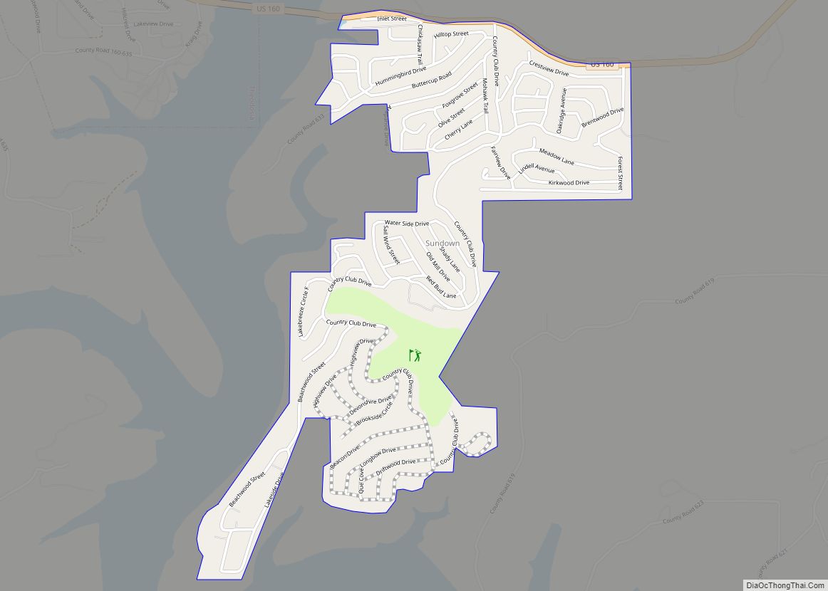
Sundown is an unincorporated community and census-designated place in Ozark County, Missouri, United States. The population was 38 at the 2000 census. Sundown was a village until 2000, when the community disincorporated. Sundown CDP overview: Name: Sundown CDP LSAD Code: 57 LSAD Description: CDP (suffix) State: Missouri County: Ozark County Elevation: 771 ft (235 m) Total Area: … Read more

Map of Tarkio city

Map of Tarkio city

Tarkio is a city in Tarkio Township, Atchison County, Missouri, United States. The population was 1,506 at the 2020 census. It was platted in 1880 and incorporated in 1881. The name “Tarkio” is from a Native American word meaning “place where walnuts grow”. Historically, the economy of the city was based on agriculture and its … Read more

Map of Taos city

Map of Taos city, Missouri

Taos is a city in Cole County, Missouri, United States. The population was 1,150 at the 2020 census. It is part of the Jefferson City, Missouri Metropolitan Statistical Area. Taos city overview: Name: Taos city LSAD Code: 25 LSAD Description: city (suffix) State: Missouri County: Cole County Founded: 1849 Elevation: 742 ft (226 m) Total Area: 6.49 sq mi … Read more

Map of Taneyville village

Map of Taneyville village

Taneyville is a village in Taney County, Missouri, United States. The population was 274 at the 2020 census. It is part of the Branson, Missouri Micropolitan Statistical Area. Taneyville village overview: Name: Taneyville village LSAD Code: 47 LSAD Description: village (suffix) State: Missouri County: Taney County Elevation: 1,073 ft (327 m) Total Area: 0.45 sq mi (1.18 km²) Land Area: … Read more

Map of Tallapoosa city, Missouri

Map of Tallapoosa city, Missouri

Tallapoosa is a city in New Madrid County, Missouri, United States. The population was 168 at the 2010 census. Tallapoosa city overview: Name: Tallapoosa city LSAD Code: 25 LSAD Description: city (suffix) State: Missouri County: New Madrid County Elevation: 272 ft (83 m) Total Area: 0.45 sq mi (1.16 km²) Land Area: 0.45 sq mi (1.16 km²) Water Area: 0.00 sq mi (0.00 km²) Total Population: … Read more

Map of Syracuse city, Missouri

Map of Syracuse city, Missouri

Syracuse is a city in Morgan County, Missouri, United States. The population was 172 at the 2010 census. In the middle of the 19th century, the city was the western terminus of the Pacific Railway that reached 108 miles from St. Louis. The current mayor of Syracuse is Duane A. Doyle. Syracuse city overview: Name: … Read more

Map of Thomasville CDP, Missouri

Map of Thomasville CDP, Missouri

Thomasville is a census-designated place in northern Oregon County, Missouri, United States. It is located nine miles northwest of Alton on Route 99. Thomasville CDP overview: Name: Thomasville CDP LSAD Code: 57 LSAD Description: CDP (suffix) State: Missouri County: Oregon County Elevation: 640 ft (200 m) Total Area: 0.38 sq mi (0.98 km²) Land Area: 0.37 sq mi (0.97 km²) Water Area: 0.01 sq mi … Read more

Map of Theodosia village

Map of Theodosia village

Theodosia is a village in Ozark County, Missouri, United States. The population was 188 at the 2020 census. Theodosia village overview: Name: Theodosia village LSAD Code: 47 LSAD Description: village (suffix) State: Missouri County: Ozark County Elevation: 889 ft (271 m) Total Area: 1.57 sq mi (4.08 km²) Land Area: 1.37 sq mi (3.55 km²) Water Area: 0.20 sq mi (0.53 km²) Total Population: 188 Population … Read more

Map of Thayer city, Missouri

Map of Thayer city, Missouri

Thayer is a city in Oregon County, Missouri, United States. The population was 1,883 at the 2020 census. Its original name was Augusta. Thayer city overview: Name: Thayer city LSAD Code: 25 LSAD Description: city (suffix) State: Missouri County: Oregon County Elevation: 610 ft (190 m) Total Area: 2.44 sq mi (6.33 km²) Land Area: 2.44 sq mi (6.33 km²) Water Area: 0.00 sq mi … Read more

Map of Terre du Lac CDP

Map of Terre du Lac CDP

Terre du Lac is an unincorporated community and census-designated places in St. Francois and Washington counties in the U.S. state of Missouri. It uses zip code 63628, from neighboring Bonne Terre. The recreational community is built around several man-made lakes and a golf course overlooking the Big River valley to the south. Terre du Lac … Read more

Map of Tarrants village

Map of Tarrants village

Tarrants is an village in central Pike County, Missouri, United States. The population was 22 at the 2010 census. Tarrants village overview: Name: Tarrants village LSAD Code: 47 LSAD Description: village (suffix) State: Missouri County: Pike County Incorporated: 1964 Elevation: 738 ft (225 m) Total Area: 0.04 sq mi (0.11 km²) Land Area: 0.04 sq mi (0.11 km²) Water Area: 0.00 sq mi (0.00 km²) Total … Read more