Map of Reed Point CDP
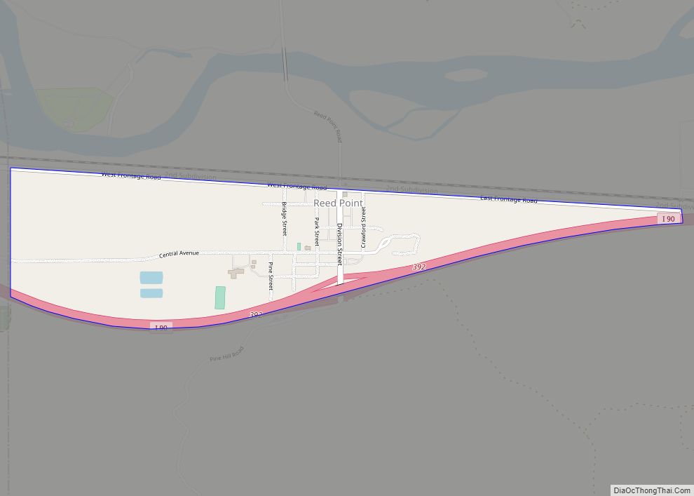
Reed Point is a census-designated place (CDP) in Stillwater County, Montana, United States. The population was 185 at the 2000 census. Reed Point CDP overview: Name: Reed Point CDP LSAD Code: 57 LSAD Description: CDP (suffix) State: Montana County: Stillwater County Elevation: 3,747 ft (1,142 m) Total Area: 0.56 sq mi (1.44 km²) Land Area: 0.56 sq mi (1.44 km²) Water Area: 0.00 sq mi ... Read more
Map of Reed Point CDP
Map of Red Lodge city
Red Lodge is a city and county seat of Carbon County, Montana, United States. As of the 2020 census, the population of the city was 2,257. Red Lodge city overview: Name: Red Lodge city LSAD Code: 25 LSAD Description: city (suffix) State: Montana County: Carbon County Elevation: 5,588 ft (1,703 m) Total Area: 2.71 sq mi (7.03 km²) Land Area: ... Read more
Map of Red Lodge city
Map of Ravalli CDP
Ravalli (Salish: sk̓ʷɫólqʷe, sk̓ʷɫʔó) is an unincorporated community and census-designated place (CDP) in Lake County, Montana, United States. The population was 76 at the 2010 census, down from 119 in 2000. At one time Charlie Allard, the country’s leading expert on breeding bison, owned the country’s largest herd of buffalo in Ravalli. Ravalli CDP overview: ... Read more
Map of Ravalli CDP
Map of Radersburg CDP
Radersburg is a census-designated place (CDP) in Broadwater County, Montana, United States. The population was 66 at the 2010 census. Radersburg was established in 1865 when gold was discovered there. It is named for Reuben Rader, a Virginian who ranched and prospected in the area. In 1869 it became the county seat of Jefferson County. ... Read more
Map of Radersburg CDP
Map of Rader Creek CDP
Rader Creek is a census-designated place (CDP) in Jefferson County, Montana, United States. The population was 363 at the 2010 census. Rader Creek CDP overview: Name: Rader Creek CDP LSAD Code: 57 LSAD Description: CDP (suffix) State: Montana County: Jefferson County Elevation: 5,532 ft (1,686 m) Total Area: 20.25 sq mi (52.45 km²) Land Area: 20.25 sq mi (52.45 km²) Water Area: 0.00 sq mi ... Read more
Map of Rader Creek CDP
Map of Pryor CDP
Pryor (Crow: Baáhpuuo) is a census-designated place (CDP) in Big Horn County, Montana, United States. The community is located on Crow Tribe’s reservation. The population was 618 at the 2010 census. The area is named for Nathaniel Hale Pryor, a sergeant in the Lewis and Clark Expedition. The first post office opened in 1892 with ... Read more
Map of Pryor CDP
Map of Pray CDP
Pray is a census-designated place and unincorporated community in Park County, Montana, United States, in the Paradise Valley. The town was founded in 1907 by Valentine Eggar, an entrepreneur. He named it after Congressman Charles Nelson Pray. Its population was 681 as of the 2010 census. Pray has a post office with ZIP code 59065, ... Read more
Map of Pray CDP
Map of Power CDP
Power is a census-designated place (CDP) in Teton County, Montana, United States. The population was 171 at the 2000 census. The town is named after Montana pioneer, Thomas Charles Power, who platted the townsite in 1910. Power CDP overview: Name: Power CDP LSAD Code: 57 LSAD Description: CDP (suffix) State: Montana County: Teton County Elevation: ... Read more
Map of Power CDP
Map of Riverbend CDP, Montana
Riverbend is a census-designated place (CDP) in Mineral County, Montana, United States. The population was 442 at the 2000 census. The Zip Code is 59872. Riverbend CDP overview: Name: Riverbend CDP LSAD Code: 57 LSAD Description: CDP (suffix) State: Montana County: Mineral County Elevation: 2,717 ft (828 m) Total Area: 4.25 sq mi (11.01 km²) Land Area: 3.94 sq mi (10.21 km²) Water ... Read more
Map of Riverbend CDP, Montana
Map of Richey town
Richey is a town in Dawson County, Montana, United States. It is located to the north of Glendive, the county seat. The population was 164 at the 2020 census. The town has a strong agriculture economy with wheat, oats and barley as the main crops as well as significant cattle and sheep ranches. Clyde Richey ... Read more
Map of Richey town
Map of Rosebud CDP, Montana
Rosebud is an unincorporated community, census-designated place and river town in Rosebud County, Montana, United States. It is located approximately 1.5 miles east of the intersection of the Yellowstone River and Rosebud Creek. Interstate 94 passes south of the town. In 1878, Rosebud began as a small post office referred to as Beeman, on the ... Read more
Map of Rosebud CDP, Montana
Map of Roscoe CDP, Montana
Roscoe is a census-designated place and unincorporated community in Carbon County, Montana, United States. As of the 2010 census it had a population of 15. Roscoe depends on light tourism and features a guest ranch, the Pioneer Pottery, and the Grizzly Bar & Grill. Situated on Montana Highway 78, Roscoe is 20 miles from Red ... Read more
Map of Roscoe CDP, Montana