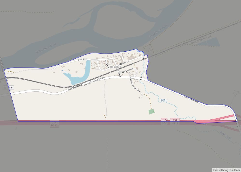
Map of Rocky Point CDP, Montana
Rocky Point is a census-designated place (CDP) in Lake County, Montana, United States. The population was 97 at the 2010 census. Rocky Point CDP overview: Name: Rocky Point CDP LSAD Code: 57 LSAD Description: CDP (suffix) State: Montana County: Lake County Elevation: 2,933 ft (894 m) Total Area: 0.61 sq mi (1.57 km²) Land Area: 0.61 sq mi (1.57 km²) Water Area: 0.00 sq mi ... Read more
Map of Rocky Point CDP, Montana
Map of Rocky Boy West CDP
Rocky Boy West is a census-designated place (CDP) in Hill and Chouteau counties in the U.S. state of Montana. The population was 890 at the 2010 census. Rocky Boy West CDP overview: Name: Rocky Boy West CDP LSAD Code: 57 LSAD Description: CDP (suffix) State: Montana County: Chouteau County, Hill County Elevation: 2,753 ft (839 m) Total ... Read more
Map of Rocky Boy West CDP
Map of Rocky Boy’s Agency CDP
Rocky Boy’s Agency is a census-designated place (CDP) in Hill County, Montana, United States. The population was 355 at the 2010 census. The settlement developed around the US Indian agency for the Rocky Boy’s Indian Reservation. Rocky Boy’s Agency CDP overview: Name: Rocky Boy’s Agency CDP LSAD Code: 57 LSAD Description: CDP (suffix) State: Montana ... Read more
Map of Rocky Boy’s Agency CDP
Map of Roberts CDP, Montana
Roberts is a census-designated place and unincorporated town in Carbon County, Montana, United States. As of the 2010 census it had a population of 361. Originally named Merritt, Roberts began as a Northern Pacific Railroad siding in 1893. The town was platted in 1902. A former settlement named Roberts was located at 45°21′28″N 109°10′08″W / ... Read more
Map of Roberts CDP, Montana
Map of Riverbend CDP, Montana
Riverbend is a census-designated place (CDP) in Mineral County, Montana, United States. The population was 442 at the 2000 census. The Zip Code is 59872. Riverbend CDP overview: Name: Riverbend CDP LSAD Code: 57 LSAD Description: CDP (suffix) State: Montana County: Mineral County Elevation: 2,717 ft (828 m) Total Area: 4.25 sq mi (11.01 km²) Land Area: 3.94 sq mi (10.21 km²) Water ... Read more
Map of Riverbend CDP, Montana
Map of Richey town
Richey is a town in Dawson County, Montana, United States. It is located to the north of Glendive, the county seat. The population was 164 at the 2020 census. The town has a strong agriculture economy with wheat, oats and barley as the main crops as well as significant cattle and sheep ranches. Clyde Richey ... Read more
Map of Richey town
Map of Ryegate town
Ryegate is a town in, and the county seat of, Golden Valley County, Montana, United States. The population was 223 at the 2020 census. Ryegate is situated on the north bank of the Musselshell River. The Milwaukee Road established Ryegate in 1908 as a depot and station stop. Ryegate town overview: Name: Ryegate town LSAD ... Read more
Map of Ryegate town
Map of Rudyard CDP
Rudyard is an unincorporated community and census-designated place (CDP) in Hill County, Montana, United States. The population was 258 at the 2010 census. The community was established as a switching station on the Great Northern Railway. The post office opened in 1910. It is named after author Rudyard Kipling. Rudyard CDP overview: Name: Rudyard CDP ... Read more
Map of Rudyard CDP
Map of Roy CDP, Montana
Roy is a census-designated place (CDP) in Fergus County, Montana, United States. Roy CDP overview: Name: Roy CDP LSAD Code: 57 LSAD Description: CDP (suffix) State: Montana County: Fergus County Total Area: 3.40 sq mi (8.82 km²) Land Area: 3.40 sq mi (8.82 km²) Water Area: 0.00 sq mi (0.00 km²) Total Population: 96 Population Density: 28.20/sq mi (10.89/km²) FIPS code: 3064675 GNISfeature ID: 775990 ... Read more
Map of Roy CDP, Montana
Map of Roundup city
Roundup is a city in and the county seat of Musselshell County, Montana, United States. The population was 1,742 during the 2020 census. Roundup city overview: Name: Roundup city LSAD Code: 25 LSAD Description: city (suffix) State: Montana County: Musselshell County Elevation: 3,215 ft (980 m) Total Area: 1.29 sq mi (3.35 km²) Land Area: 1.29 sq mi (3.35 km²) Water Area: 0.00 sq mi ... Read more
Map of Roundup city
Map of Savage CDP, Montana
Savage CDP overview: Name: Savage CDP LSAD Code: 57 LSAD Description: CDP (suffix) State: Montana FIPS code: 3066550 Online Interactive Map Savage online map. Source: Basemap layers from Google Map, Open Street Map (OSM), Arcgisonline, Wmflabs. Boundary Data from Database of Global Administrative Areas. Savage location map. Where is Savage CDP? Savage Road Map Savage ... Read more
Map of Savage CDP, Montana
Map of Santa Rita CDP, Montana
Santa Rita is a census-designated place (CDP) in Glacier County, Montana, United States. The population was 113 at the 2010 census. It is located along Montana Secondary Highway 213, 5 miles north of Cut Bank. Santa Rita CDP overview: Name: Santa Rita CDP LSAD Code: 57 LSAD Description: CDP (suffix) State: Montana County: Glacier County ... Read more
Map of Santa Rita CDP, Montana